Warm Spring Day Back Door Front Drops Southward Tonight
Severe Weather Risk Thursday
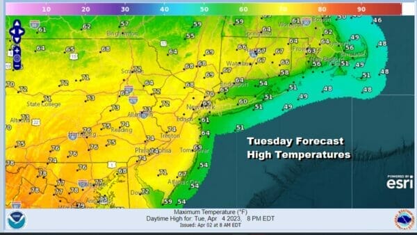
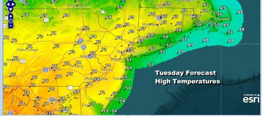
We often lament that spring weather in the Northeast isn’t really a joyride but every so often in the early part of the spring you get a set up where you aren’t concerened about a backdoor front or an onshore wind. Today is one of those days and the outcome is a day where we will have mostly sunny skies for most of the day. The satellite loop and the radars are showing clouds and showers moving from west to east across upstate New New York and Northern New England. This is the backdoor front and it will not move southward until tonight. As a result, temperatures today will be in the 70s and even close to the coast we will see warm temperatures before any sea breeze kicks in.
SATELLITE

WEATHER RADAR

Tonight the backdoor cold front will move southward and it will likely come to a grinding halt somewhere across Central New Jersey Wednesday morning. This is going to split the area in half. Most lows tonight will be in the upper 40s to mid 50s but it is the dayside Wednesday where we will see a wide range in high temperatures.
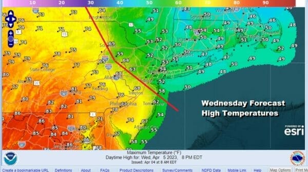
We have drawn the approximate location of the warm front. If you are to the south and west of that front highs will reach the upper 70s and lower 80s across Southern Pennsylvania and Southern New Jersey with sunshine. If you are northeast of the front in the Northern New Jersey to Southern and Southeastern New England, you will be sitting in clouds all day with an onshore wind and highs just in the upper 40s and lower 50s.
The warm front will move northward Wednesday night in response to strong low pressure moving north of the Northernmost Great Lakes and into Canada. The trailing cold front will begin to move eastward Thursday. Ahead of it a southwest flow and some sunshine will mean temperatures inland will reach the lower 80s possibly as far north as NYC.

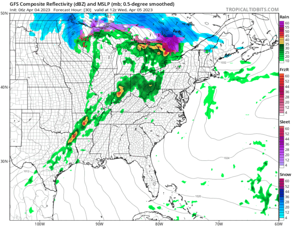
Late in the day Thursday the cold front will near and we will see showers and thunderstorms with the frontal passage into Thursday night. The set up is different from last Saturday and while we do have a marginal risk for severe weather being indicated, this doesn’t look like a set up that evoles into anything other than isolated severe thunderstorm risk.

We continue to be optimistic regarding the Friday to Easter Sunday time frame though it will be on the chilly side for the 3 day stretch. Low pressure will pass to the south Friday and Saturday so that should leave much in the area in some sunshine. Friday and Saturday highs will be just in the 50s while Easter Sunday could be a tad higher in the upper 50s and lower 60s.
BE SURE TO DOWNLOAD THE FREE METEOROLOGIST JOE CIOFFI WEATHER APP &
ANGRY BEN’S FREE WEATHER APP “THE ANGRY WEATHERMAN!
MANY THANKS TO TROPICAL TIDBITS & F5 WEATHER FOR THE USE OF MAPS
Please note that with regards to any severe weather, tropical storms, or hurricanes, should a storm be threatening, please consult your local National Weather Service office or your local government officials about what action you should be taking to protect life and property.


