Long Island Heat Humidity And Severe Weather Risks Next 2 Days

Weather in 5/Joe & Joe Weather Show Latest Podcast
Long Island Heat Humidity And Severe Weather Risks Next 2 Days
After a bout of some cloud cover this morning we have broken out wide open in sunshine for this afternoon. Thanks to a wind off the ocean and a few hours of full sunshine lost, temperatures are having a bit of struggle today. Highs will be in the 70s. We also want to include the chance for a pop up shower or thunderstorm but the odds of this are rather low. If one does form it will be short lived.
SATELLITE

The satellite shows mostly sunny skies from Maine to North Georgia though the clouds in Southern New England do stand out a bit. That is being caused by a very small weak upper air disturbance moving through. However the radars at least early this afternoon are not showing any rain echoes.
WEATHER RADAR


Humidity will be increasing overnight and temperatures won’t be going anywhere setting us up for a hot humid day on Tuesday. Inland highs will reach the upper 80s to some lower 90s. Temperatures will be about 10 degrees cooler at the beaches.

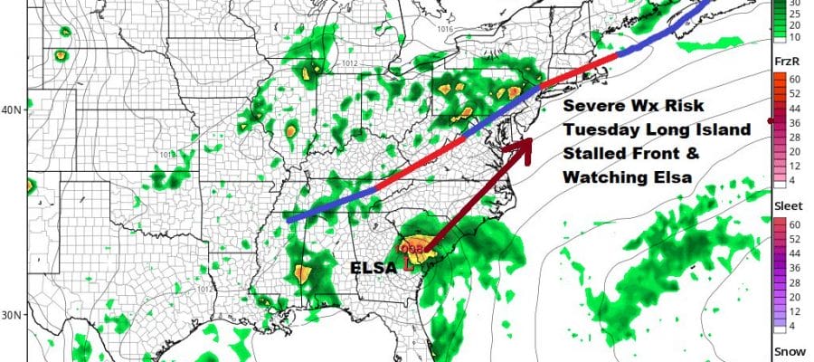
The high dew points and a very unstable atmosphere set Long Island up for Severe Weather Risk Tuesday afternoon noon and evening. The Storm Prediction Center has Long Island at a marginal risk for severe weather. Models seem to be focusing on strong storm development near the coast rather than inland.

Wednesday is another hot and humid day with highs reaching the upper 80s and lower 90s. There is thunderstorm risk late in the day and in the evening though the risk may be greater inland where we have a marginal risk for severe weather already indicated. However I would not be surprised to see Long Island included in this risk zone.

Wednesday’s front is going to stall nearby which leaves us at risk for thunderstorms Thursday. It also at least opens the door to the possibility that what is left of Elsa rides up the coast. Latest GFS model runs want to take this up I-95 all the way into Southeastern New England. This could certainly enhance thunderstorm activity we are forecast to get Thursday into Friday regardless. The official NHC forecast for Elsa remains offshore but we will have to keep an eye on this frontal boundary to see if it stalls out as advertised. That will make for a wetter scenario for the end of this week.
BE SURE TO DOWNLOAD THE FREE METEOROLOGIST JOE CIOFFI WEATHER APP &
ANGRY BEN’S FREE WEATHER APP “THE ANGRY WEATHERMAN!

MANY THANKS TO TROPICAL TIDBITS & F5 WEATHER FOR THE USE OF MAPS
Please note that with regards to any severe weather, tropical storms, or hurricanes, should a storm be threatening, please consult your local National Weather Service office or your local government officials about what action you should be taking to protect life and property.