Let The Summer Weekend Begin 90s Today Sunday
Severe Weather Risk Inland Sunday Evening

Let The Summer Weekend Begin 90s Today Sunday
Severe Weather Risk Inland Sunday Evening
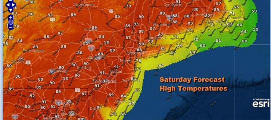
It isn’t quite summer but considering how the spring has been, if summer weather of heat and humidity is your thing, then you have it this weekend. We will see sunshine both day and Sunday. Humidity levels will be high for this time of year. Normally in May when it gets hot like this it is usually dry. However yesterday’s southeast wind ahead of a warm front and thunderstorms took care of that. Highs today will be in the mid to upper 90s. Temperatures along the coast will rise to 85 to near 90 and of course the beaches will offer sea breeze relief. There is a far outside chance that an isolated thunderstorm pops up this evening inland. It is a very small chance but with all the daytime heating I want to cover for that small possibility.
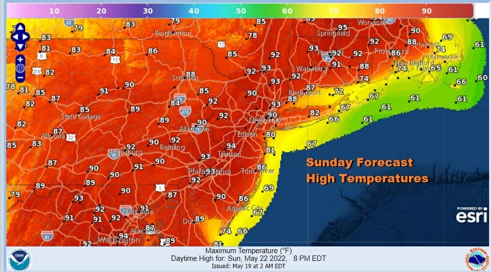
A warm humid night lies ahead with most lows in the 60s to lower 70s. Sunday will be the second and the last of the very hot days. Sunshine most of the day will take highs to the low and middle 90s so about 3 to 5 degrees lower than today. We have a cold front approaching and that opens the door to severe weather risk Sunday evening but most storms will be well inland, and after sunset they will likely weaken.
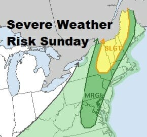
The Storm Prediction Center is indicating a marginal risk for severe weather Sunday and again this will likely be during the evening. The cold front isn’t particularly strong nor is the upper air trough that is driving the cold front eastward. The highest chances for anything severe will be to the north in upstate New York and into Western New England.
SATELLITE

WEATHER RADAR

As far as the week ahead is concerned, there doesn’t appear to be anything too threatening. Monday we will have leftover clouds and some sun. There could still be a shower as Sunday’s cold front lingers around for another day. Tuesday looks like a good day with sunshine. Highs both Monday and Tuesday will be just into the 70s which is about where average is this time of year.

The next cold front won’t get here until Friday so Wednesday and Thursday won’t be too bad though clouds will be moving in and there could be a few showers around Wednesday night into Thursday morning. A warm front goes by and we turn to a warm and humid air mass for Thursday and Friday . This sets us up for thunderstorms late Friday as a cold front passes. I have been optimistic about the Memorial Day holiday weekend since last week, and I see no reason to change my outlook. The weekend looks mostly dry for all three days with reasonable temperatures to start and warmer weather for the second half.
BE SURE TO DOWNLOAD THE FREE METEOROLOGIST JOE CIOFFI WEATHER APP &
ANGRY BEN’S FREE WEATHER APP “THE ANGRY WEATHERMAN!
MANY THANKS TO TROPICAL TIDBITS & F5 WEATHER FOR THE USE OF MAPS
Please note that with regards to any severe weather, tropical storms, or hurricanes, should a storm be threatening, please consult your local National Weather Service office or your local government officials about what action you should be taking to protect life and property.


