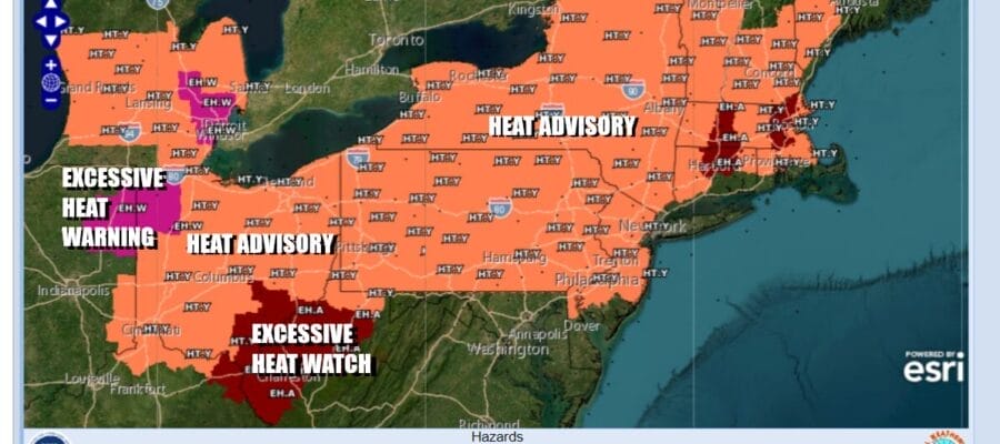
Let the Heatwave Begin! 90s Tuesday Through Sunday, Heat Advisories Posted

Let the Heatwave Begin! 90s Tuesday Through Sunday, Heat Advisories Posted

It looks like we are in for a long duration heatwave for Eastern Pennsylvania to Southern New England. Along the coast and that includes Long Island and Southeastern New England the ocean will help to keep temperatures down a bit but by Wednesday local sea breezes will be confined mainly to shore locations.
SATELLITE WITH LIGHTNING STRIKES

WEATHER RADAR

Meanwhile it is a beautiful day of sunshine and temperatures in the 80s away from the ocean. Humidity levels are coming up some today but it is still reasonably comfortable. That is going to change as high pressure moves offshore and winds from the south and then southwest start to bring up the hot air.

A strong ridge of high pressure aloft will cover the Eastern US for the rest of the week reaching peak strength Wednesday and Thursday. The Bermuda high is anchored offshore and not going anywhere. The next cold front in the Plains has no chance of making it east as long as the upper ridge holds.
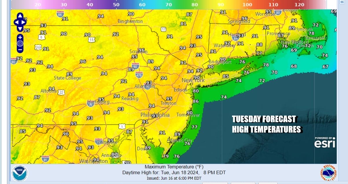
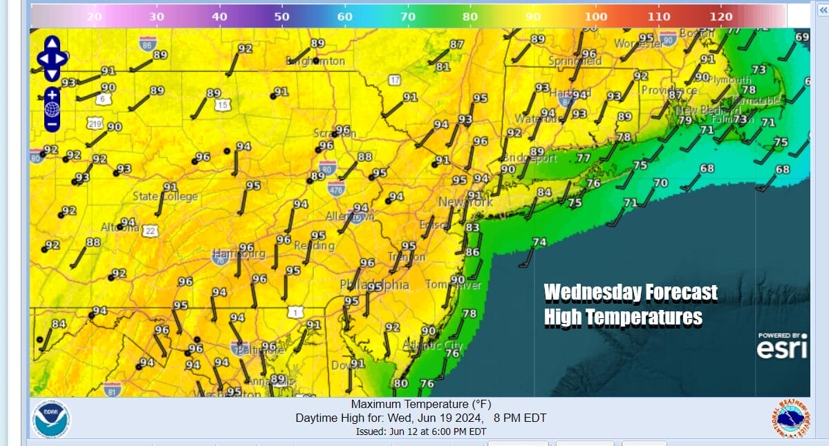
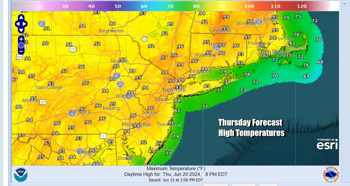
Tuesday will begin what will be a string of 90 degree plus highs that likely lasts through Sunday. Sunshine Tuesday will bring highs in the low and middle 90s inland with 80s along the coast. Then as we head into Wednesday and Thursday it will be oppressive with heat and humidity. Look for sunshine all day long and high humidity. There is the outside chance for an isolated thunderstorm mainly inland. Highs both Wednesday and Thursday will be in the mid to upper 90s. Some hot spots might touch 100.
The upper ridge begins to slowly weaken at the end of the week and over the weekend. That will allow a cold front to approach sometime late Sunday or Sunday night. Until then we see another very hot and very humid day for Friday. There is the risk for a scattered late day or nighttime thunderstorm. Highs Friday again will be in the mid to upper 90s.
Saturday and Sunday we will see hot and humid conditions but temperatures might ease a bit off their peak highs of late week. Saturday and Sunday highs will be in the low to mid 90s. Each day will be cooler along the shore so that will be the place to be. Thunderstorms are possible late Sunday or Sunday night depending on a the timing of a cold front. Then we catch a bit of a break early next week.
BE SURE TO DOWNLOAD THE FREE METEOROLOGIST JOE CIOFFI WEATHER APP &
ANGRY BEN’S FREE WEATHER APP “THE ANGRY WEATHERMAN!
MANY THANKS TO TROPICAL TIDBITS FOR THE USE OF MAPS
Please note that with regards to any severe weather, tropical storms, or hurricanes, should a storm be threatening, please consult your local National Weather Service office or your local government officials about what action you should be taking to protect life and property.
(Amazon is an affilate of Meteorologist Joe Cioffi & earns commissions on sales.)


