
Heat Advisories & Excessive Heat Watches Posted Beginning Tuesday
As Heatwave Gets Underway

Heat Advisories & Excessive Heat Watches Posted Beginning Tuesday
As Heatwave Gets Underway
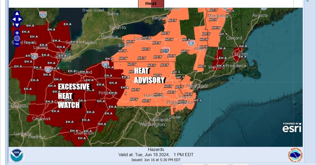
The first Excessive Heat Watches & Heat Advisories have been posted as a heatwave gets underway in parts of the Northeast & Northern Mid Atlantic states as well as the Ohio Valley. Additional watches, warnings, and advisories are likely going up in the coming days as a strong ridge of high pressure aloft builds into the Northeast and Mid Atlantic states later this week. The hottest temperatures will begin Wednesday coupled with very high humidity. Heat indices are forecast to reach 100-105 range later this week. The heatwave is likely to last at least 6 days beginning Tuesday.

This contrasts to the weather that the Northeast and Mid Atlantic states has been enjoying and we are wrapping up a Father’s Day that was abundant in sunshine and low in humidity. High clouds to the northwest are from a weather system in the Western Great Lakes and that system is passing well to the north as the upper high builds. Skies will be mainly clear tonight. Most lows will be in the upper 50s to mid 60s. Monday will be very warm with sunshine. The humidity levels will rise but it will still be reasonably comfortable. After highs will be in the mid to upper 80s except cooler in Southeastern New England and Long Island thanks to a south-southwest wind. Inland highs in some warmer areas in Southeastern Pennsylvania and New Jersey could approach 90 Monday afternoon.
SATELLITE WITHLIGHTNING STRIKES
WEATHER RADAR

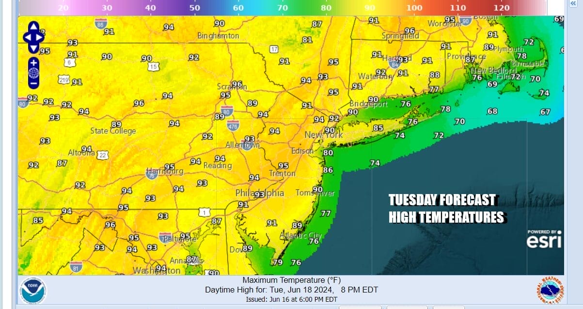
Tuesday we see humidity levels rising into the 60s everywhere making for uncomfortable conditions. We will also see temperatures rise as sunshine takes highs into the low and middle 90s in many inland locations. Once again temperatures will be cooler along exposed coastal locations thanks to a wind off the ocean but the cooler air will be confined to the immediate coast and not spread to areas further inland.
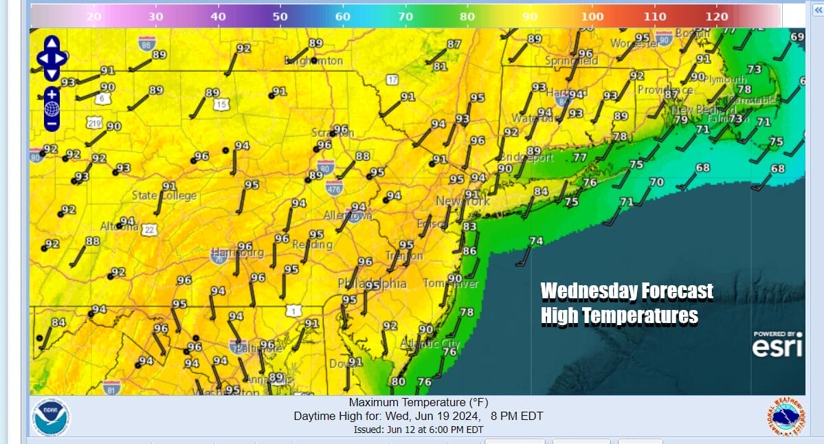
Wednesday the heat increases and the humidity also rises further making for oppressive conditions. Heat indices will likely approach and go over 100. Highs both Wednesday and Thursday will be in the middle to upper 90s and it would not be a surprise to see some hot spots going to 100. Sunshine will dominate the weather all three days and we do not see much of a chance for a thunderstorm. If one does pop up it would likely be isolated in nature.
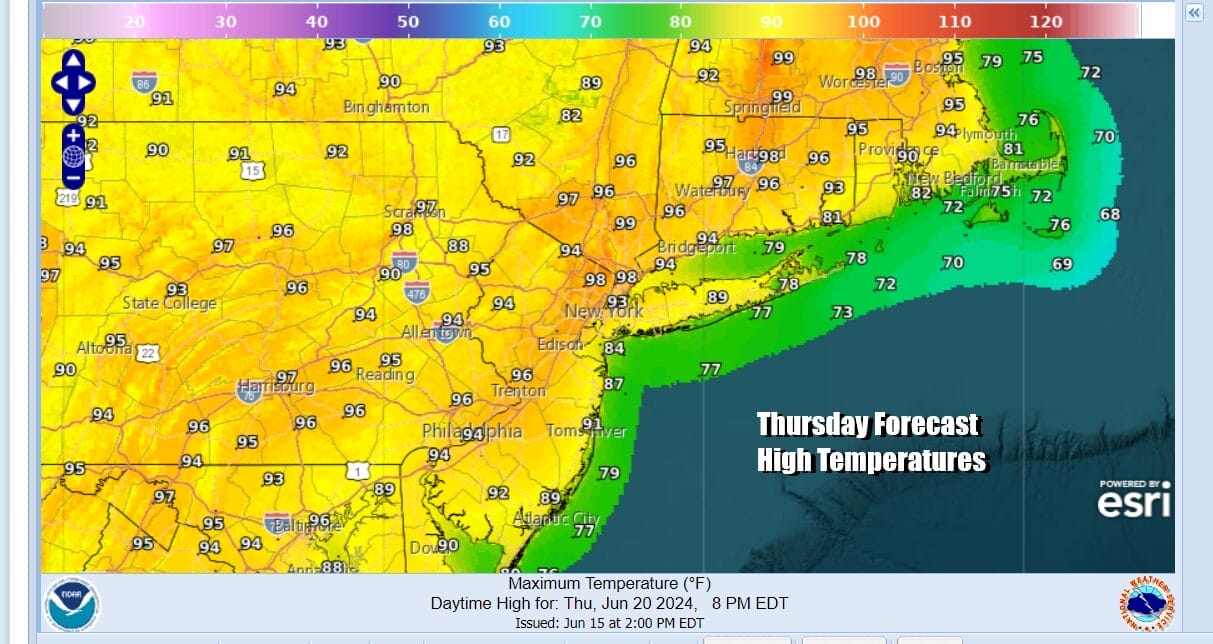
There is an upper trough that will be dropping southeastward into New England. It is weak but it might be enough to set off some scattered thunderstorms inland Thursday night as it goes by but it will do nothing to bring real relief. The upper high is still too strong to allow for a cold front to pass through and break the back of this heatwave. As a result, hot temperatures will likely continue Friday and into next weekend. Highs will continue to reach the mid to upper 90s Friday and in the low and middle 90s Saturday into Sunday. By late Sunday. A cold front of importance likely comes late Sunday and Sunday night with thunderstorms (and perhaps severe weather) and this should bring an end to the heat and humidity next week.
BE SURE TO DOWNLOAD THE FREE METEOROLOGIST JOE CIOFFI WEATHER APP &
ANGRY BEN’S FREE WEATHER APP “THE ANGRY WEATHERMAN!
MANY THANKS TO TROPICAL TIDBITS FOR THE USE OF MAPS
Please note that with regards to any severe weather, tropical storms, or hurricanes, should a storm be threatening, please consult your local National Weather Service office or your local government officials about what action you should be taking to protect life and property.
(Amazon is an affilate of Meteorologist Joe Cioffi & earns commissions on sales.)


