Lake Effect Snow Chilly Weekend
Lake Effect Snow Chilly Weekend
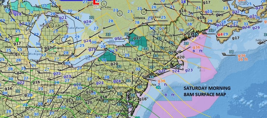
We are seeing a continuation of the same chilly northwest flow from Canada on a gusty northwest wind. Lake effect snow and lake effect snow warnings continue for parts of Southwestern and North Central New York where the snow is being measured in feet. The flow continues to be rather moist at the higher levels of the atmosphere thanks to the fact that the Great Lakes remain unfrozen this year. Notice that even though the flow of air is from Canada the air is not all that cold, at least not yet. The air will gradually turn colder as we move through next week with a couple of colder shots coming down.
We are starting out the day with some sunshine however there are some snow showers occurring over parts of Southeastern Pennsylvania and Southern New Jersey. There probably will be some snow showers running around today as temperatures reach the upper 30s and lower 40s.
SATELLITE LOOP

REGIONAL RADAR

LOCAL RADAR NEW YORK CITY

LOCAL RADAR PHILADELPHIA


The activity on the radar over SE Pennsylvania and Northern Delaware seems to be rather impressive (relatively speaking) on the radar with some of that snow actually reaching the ground! Such is the case this winter as snow lovers grasp for every flake they can.
Look for more of the same on Sunday but with few clouds, more sun and temperatures in the upper 30s and lower 40s. A series of weak clipper systems will be coming through this week and for now they seem unimpressive.
SNOW REMOVAL COMPANIES FOR YOUR WINTER NEEDS
LONG ISLAND ROCKLAND COUNTY Connecticut

![]()

ROCKLAND COUNTY TRI STATE SNOW REMOVAL JOHNSTOWN PA


FiOS1 News Weather Forecast For Long Island
FiOS1 News Weather Forecast For New Jersey
FiOS1 News Weather Forecast For Hudson Valley
NATIONAL WEATHER SERVICE SNOW FORECASTS
LATEST JOESTRADAMUS ON THE LONG RANGE
Weather App

Don’t be without Meteorologist Joe Cioffi’s weather app. It is really a meteorologist app because you get my forecasts and my analysis and not some automated computer generated forecast based on the GFS model. This is why your app forecast changes every 6 hours. It is model driven with no human input at all. It gives you an icon, a temperature and no insight whatsoever.
It is a complete weather app to suit your forecast needs. All the weather information you need is right on your phone. Android or I-phone, use it to keep track of all the latest weather information and forecasts. This weather app is also free of advertising so you don’t have to worry about security issues with your device. An accurate forecast and no worries that your device is being compromised.
Use it in conjunction with my website and my facebook and twitter and you have complete weather coverage of all the latest weather and the long range outlook. The website has been redone and upgraded. Its easy to use and everything is archived so you can see how well Joe does or doesn’t do when it comes to forecasts and outlooks.
Just click on the google play button or the apple store button on the sidebar for my app which is on My Weather Concierge. Download the app for free. Subscribe to my forecasts on an ad free environment for just 99 cents a month.
Get my forecasts in the palm of your hand for less than the cost of a cup of Joe!


