Labor Day Weekend of Sunshine Heat Humidity Begin Monday
No Rain Until At Least Thursday

Labor Day Weekend of Sunshine Heat Humidity Begin Monday
No Rain Until At Least Thursday
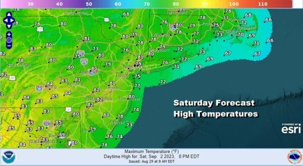
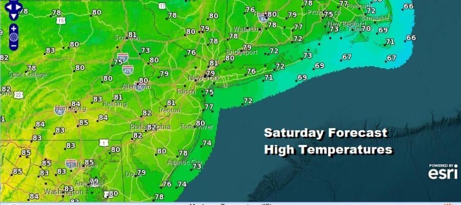
Day one of the Labor Day holiday weekend is undeway and it will be the coolest of the three days. It will also be the day of the lowest relative humidity so enjoy that because starting Sunday, dew points will be rising. Nothing has changed regarding the holiday weekend. There will be no rain right through, and temperatures will on the climb upward. Actually that climb begins today with lots of sunshine and highs reaching the upper 70s and lower 80s. If you are headed for the beaches be advised that there is a moderate risk for rip currents so excercise caution if you are swiming at the ocean beaches.
SATELLITE WITH LIGHTNING STRIKES

WEATHER RADAR

Tonight will be warmer than past nights as the core of the dry air mass moves eastward. Skies will be claear with most lows in the 60s except for 50s in cool spots. Sunday will be a very warm to hot day and it will be more humid though the dew points won’t be too out of hand. Temperatures will be on the rise and sunshine will take highs to the mid 80s to near 90 degrees in some areas. We will plenty of sunshine and once again no rain is forecast.

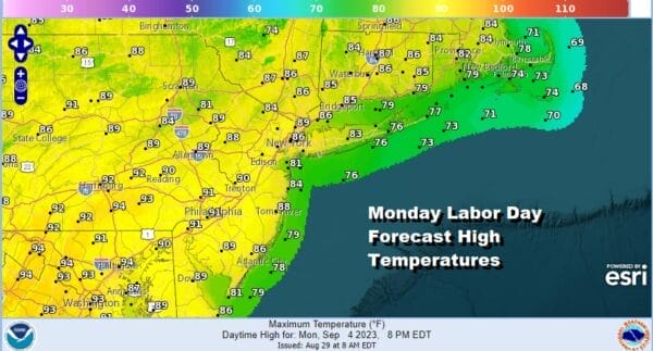
Monday will be hot and it will be humid but again there will be no rain in the forecast thanks to the stable upper air ridge along the east coast. Monday will definitely be a late season pool or beach day with sunshine taking highs to the upper 80s and lower 90s. Dew points will be well into the 60s to near 70 so Monday will be an uncomfortable day for just about everyone.
This summer has not seen three days or more in a row of 90 degree highs for much of the coastal Norhteast at least. We will likely see it now that we are near the end of the summer season with Tuesday and Wednesday being both very hot days with sunshine and highs reaching the low and even some middle 90s. Thursday we will likely see the next cold front approach with the chance for some late showers or a thunderstorm. Thursday highs will be in the upper 80s and lower 90s and that should be the last 90 degree day of this current stretch. There are no tropical storms or hurricanes that pose any threat to the US this weekend so enjoy the holiday.
BE SURE TO DOWNLOAD THE FREE METEOROLOGIST JOE CIOFFI WEATHER APP &
ANGRY BEN’S FREE WEATHER APP “THE ANGRY WEATHERMAN!
MANY THANKS TO TROPICAL TIDBITS FOR THE USE OF MAPS
Please note that with regards to any severe weather, tropical storms, or hurricanes, should a storm be threatening, please consult your local National Weather Service office or your local government officials about what action you should be taking to protect life and property.
(Amazon is an affilate of Meteorologist Joe Cioffi & earns commissions on sales.)


