Jose Looking More Like A Noreaster Than A Hurricane
Jose Looking More Like A Noreaster Than A Hurricane
WATCHES AND WARNINGS
——————–
CHANGES WITH THIS ADVISORY:
The Tropical Storm Watch has been discontinued from Fenwick Island,
Delaware to Fire Island Inlet, New York.
SUMMARY OF WATCHES AND WARNINGS IN EFFECT:
A Tropical Storm Warning is in effect for…
* Watch Hill to Hull
* Block Island
* Martha’s Vineyard
* Nantucket
A Tropical Storm Watch is in effect for…
* The coast of Long Island from Fire Island Inlet to Port Jefferson
* New Haven to Watch Hill
SATELLITE LOOP

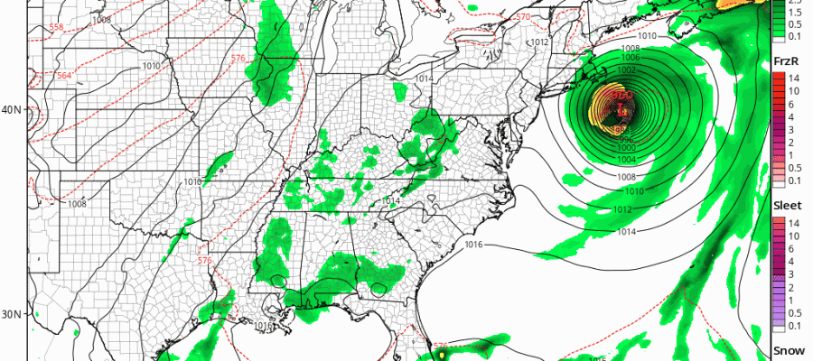
Hurricane Jose is gradually transitioning into a post tropical ocean storm as it continues to move to the north. The position of Jose is far enough east that the National Hurricane Center has taken down the Tropical Storm Watch for all areas except for Suffolk County on Long Island and the Central and Eastern coast of Connecticut. Tropical Storm Warnings are up for areas to the east. As far as this evening and tonight are concerned, clouds will begin to sweep in from off the ocean to the northwest but the western most outer band of rain will not arrive until tomorrow morning. Otherwise it is a warm humid night with temperatures in the 60s to near 70 and a freshening northeast wind.
REGIONAL RADAR

Radars both regionally and locally are still relatively quiet. The offshore position of Jose is so far out right now that we cant even see the westernmost echos on the radar.
LOCAL RADAR NEW YORK CITY

LOCAL RADAR PHILADELPHIA


With regards to Tuesday and Tuesday night inland areas will see minimal impact with perhaps one band of rain coming in during the morning and then weakening. There could be some steady rain over Central & Eastern Long Island and Southeastern Connecticut with fringe gale force winds. Even here conditions will be relatively easy to manage. The only other issue that is still in play is the possibility of coastal flooding and here Western Long Island south shore could see tides 1 to 2 feet above normal into a new moon (Wednesday) and the autumnal equinox (first day of Fall Thursday). This could create moderate coastal flooding and beach erosion at the time of high tide.
Weather conditions should improve from west to east on Wednesday as we wait and see what Jose does regarding any looping action. For now it will just be a return to some sunshine and temperatures in the 80s while clouds may still be an issue along the immediate coast and areas east of NYC.
…JOSE HOLDING STEADY IN STRENGTH…
…DANGEROUS SURF AND RIP CURRENTS EXPECTED TO CONTINUE ALONG THE
EAST COAST OF THE UNITED STATES…
SUMMARY OF 500 PM EDT…2100 UTC…INFORMATION
———————————————-
LOCATION…34.8N 71.1W
ABOUT 250 MI…405 KM E OF CAPE HATTERAS NORTH CAROLINA
ABOUT 445 MI…720 KM S OF NANTUCKET MASSACHUSETTS
MAXIMUM SUSTAINED WINDS…75 MPH…120 KM/H
PRESENT MOVEMENT…N OR 360 DEGREES AT 10 MPH…17 KM/H
MINIMUM CENTRAL PRESSURE…977 MB…28.85 INCHES
DISCUSSION AND 48-HOUR OUTLOOK
——————————
At 500 PM EDT (2100 UTC), the center of Hurricane Jose was located
near latitude 34.8 North, longitude 71.1 West. Jose is moving toward
the north near 10 mph (17 km/h), and this motion is expected during
the next day or so. A turn to the northeast is expected to occur on
Tuesday night. On the forecast track, the center of Jose is
forecast to pass well offshore of the Delmarva peninsula tonight and
Tuesday, and pass well to the east of the New Jersey coast on
Wednesday.
Maximum sustained winds remain near 75 mph (120 km/h) with higher
gusts. Little change in strength is forecast during the next 48
hours.
Hurricane-force winds extend outward up to 60 miles (95 km) from the
center and tropical-storm-force winds extend outward up to 230 miles
(370 km).
The estimated minimum central pressure is 977 mb (28.85 inches).
GET JOE A CIGAR IF YOU LIKE
FiOS1 News Weather Forecast For Long Island
FiOS1 News Weather Forecast For New Jersey
FiOS1 News Weather Forecast For Hudson Valley


