Hurricane Jose Noreaster Conditions Confined to Coastal Areas Only
Hurricane Jose
Noreaster Conditions Confined to Coastal Areas Only
Hurricane Jose continues to move northward and is looking more and more like a post tropical cyclone rather than a purely tropical one. We have been emphasizing that except for the immediate coast which will deal with some wind and some rain, most of the area will not have any serious issues. The primary issue for the coast will be coastal flooding at high tides for the next several days. Winds will be gusty along the New Jersey Coast & over Long Island and will be at gale force for a time. Again this should be manageble as long as the track of Jose remains offshore.
SATELLITE LOOP

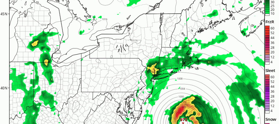
Weather models are having a tough time handling how the bands of rain hold together as they rotate westward. It looks as if there will be one band of rain that will move in from off the ocean before day break on Tuesday and move inland. That band weakens as it moves northward so the further north and west you are from the coast the less you will get. Even what you do get will be manageable.
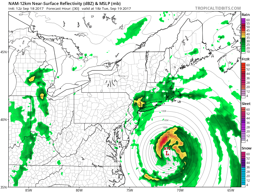
NAM MODEL FOR TUESDAY AFTERNOON
With the track of Jose shifting slightly to the east this lessens the wind impact. There will be no wind impact of consequence inland other than it might get a little breezy. Along the immediate coast for both New Jersey and for Long Island especially the east end it should be windy with the strongest gusts of over 40 mph over the East End of Long Island. The biggest issue will be coastal flooding at high tide. Northerly winds gradually take over in New Jersey so this lessens the coastal flooding impact. The greatest risk for Coastal Flooding for New Jersey is Tuesday night into Wednesday. Moderate coastal flooding is possible with tides 2 to 3 feet above normal
For Long Island it is a bit different with the wind from the east and then shifting to the northeast and north Tuesday night. Coastal Flood Watch is in effect for Long Island as well as New York Harbor and the surrounding counties in New Jersey. Moderate coastal flooding is expected with tide running 2 to as much as 3 feet above normal with moderate coastal flooding expected.

As far as rainfall is concerned you can see how sharp the cutoff is with the rain to the west. Long Island and Southeastern Connecticut will see more with the range from 1/2 inch in western areas and 2 inches or more east. For New Jersey and the Hudson Valley the rain along the coast could reach 1/2 inch but the further north and west you go, the less you will see. All in all this is not going to be a big problem. The coast will have more to deal with but unless we see some sort of last minute leftward shift, it should be manageable.
LATEST ADVISORY FROM THE NATIONAL HURRICANE CENTER
COAST OF THE UNITED STATES…
SUMMARY OF 200 PM EDT…1800 UTC…INFORMATION
———————————————-
LOCATION…34.2N 71.0W
ABOUT 265 MI…425 KM ESE OF CAPE HATTERAS NORTH CAROLINA
ABOUT 490 MI…790 KM S OF NANTUCKET MASSACHUSETTS
MAXIMUM SUSTAINED WINDS…75 MPH…120 KM/H
PRESENT MOVEMENT…N OR 10 DEGREES AT 9 MPH…15 KM/H
MINIMUM CENTRAL PRESSURE…977 MB…28.85 INCHES
WATCHES AND WARNINGS
——————–
CHANGES WITH THIS ADVISORY:
None.
SUMMARY OF WATCHES AND WARNINGS IN EFFECT:
A Tropical Storm Warning is in effect for…
* Watch Hill to Hull
* Block Island
* Martha’s Vineyard
* Nantucket
A Tropical Storm Watch is in effect for…
* Fenwick Island to Sandy Hook
* Delaware Bay South
* East Rockaway Inlet to Watch Hill
DISCUSSION AND 48-HOUR OUTLOOK
——————————
At 200 PM EDT (1800 UTC), the center of Hurricane Jose was located
near latitude 34.2 North, longitude 71.0 West. Jose is moving
toward the north near 9 mph (15 km/h) and this general motion is
expected to continue during the next day or so. A turn to the
northeast is expected to occur on Tuesday night. On the forecast
track, the center of Jose is forecast to pass well offshore of the
Outer Banks of North Carolina this evening, pass well east of the
Delmarva peninsula tonight and Tuesday, and pass well to the east of
the New Jersey coast on Wednesday.
Maximum sustained winds remain near 75 mph (120 km/h) with higher
gusts. Little change in strength is forecast during the next 48
hours.
Hurricane-force winds extend outward up to 60 miles (95 km) from
the center and tropical-storm-force winds extend outward up to 230
miles (370 km).
FiOS1 News Weather Forecast For Long Island
FiOS1 News Weather Forecast For New Jersey
FiOS1 News Weather Forecast For Hudson Valley