It’s Not Drought Breaking But Its a Start Rain Wednesday Night into Thursday Snow Elevated Interior Northeast

It’s Not Drought Breaking But Its a Start Rain Wednesday Night into Thursday Snow Elevated Interior Northeast
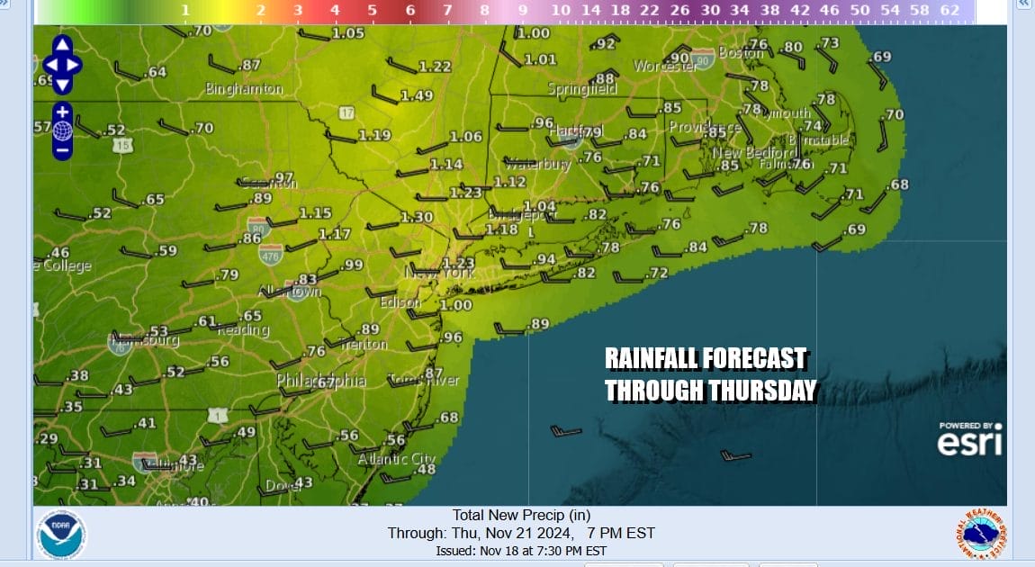
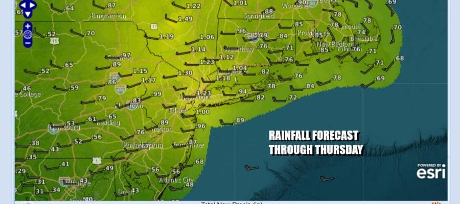
The rainfall deficit right now is about 8 to 10 inches and we certainly are not going to wipe that away with this storm system and cold front but 3/4 to an inch or so is a good start and it would be the most rain we have seen since the middle of June and only the 3rd or 4th time it has rained in the last 3 months! This forecast is through Thursday night and there may be additional showery rains Friday. In the meantime today is another sunny day with wildfire risk.
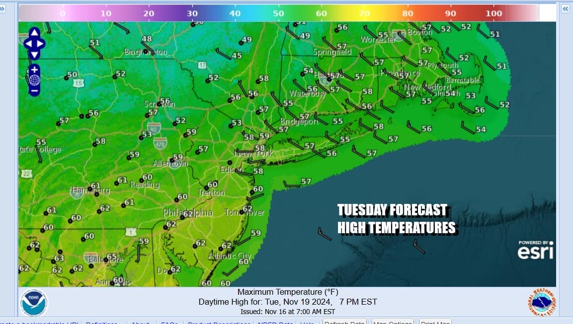
Most temperatures Tuesday will be in the mid to upper 50s except for lower 60s in Southern New Jersey. We have no issues Tuesday night as skies should be clear with most lows in the 40s except for 30s in colder spots. Radars are nice and quiet today and satellite loops show just a few patchy clouds from place.
SATELLITE WITH LIGHTNING STRIKES

WEATHER RADAR

Wednesday sees the beginning of moisture coming in from off the ocean on an east wind. To the west low pressure will be developing over the Great Lakes with a weather front extending southward through the Appalachians. Look for any sunshine to give way to increasing clouds Wednesday with most highs in the 50s.

Wednesday night into Thursday morning we will see low pressure in Michigan redevelop right overhead. The associated front will swing northeast from the southwest and that will bring a 6 hour or so period of rain. If the triple point of the three fronts moves overhead we should see a solid burst of rain as the low goes by and perhaps even a rumble or two of thunder and a brief burst of heavy rain.

Once that area plays through the next issue will be the upper air storm system and associated short waves that will be rotating around it. That will be sitting across the Northeast and Mid Atlantic probably into Saturday. This will generate showery rains Thursday night and especially on Friday along with blustery cold conditions. Rainfall amounts into Friday morning should be on the order of 3/4 to 1.25 inches from north to south.
Very cold air aloft that will mix down to the surface will also mean that interior elevated areas to the north, west and southwest could see a change to wet snow. Situations like this are very difficult to forecast and at least through Thursday night the main area of snow will likely be in the Central Appalachians as well as parts of Eastern Ohio and Western Pennsylvania.

You can certainly expect changes in this snow outlook for inland areas as we will see cold showery rains near the coast Friday (not continuous) and the irisk for rain and/or snow inland with higher elevations having a higher chance for plowable snow. At least the additional precipitation in whatever form will be a good thing. Expect some surprises to occur including maybe some wet snow or graupel getting into the mix closer to the coast Friday. Temperatures Thursday will be in the upper 40s to lower 50s for highs. Friday temps will be in the cold low 40s and even upper 30s in areas just inland. Lingering clouds and precipitation could last into early Saturday before weather conditions genuinely improve.
BE SURE TO DOWNLOAD THE FREE METEOROLOGIST JOE CIOFFI WEATHER APP &
ANGRY BEN’S FREE WEATHER APP “THE ANGRY WEATHERMAN!
MANY THANKS TO TROPICAL TIDBITS FOR THE USE OF MAPS
Please note that with regards to any severe weather, tropical storms, or hurricanes, should a storm be threatening, please consult your local National Weather Service office or your local government officials about what action you should be taking to protect life and property.


