Independence Day Mostly Dry Warm

Independence Day Mostly Dry Warm
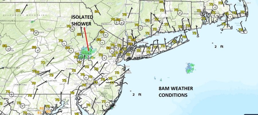
We are here at the 4th of July Independence Day and there is a bit of a small issue this morning. Dry air is pushing southward on north winds while several very small upper air disturbances are moving across Pennsylvania. There are one or two isolated downpours on the radar this morning but that really is all there is. Once they play through in the next couple of hours skies should become partly to mostly sunny. Temperatures will reach into the 80s but along the shore with a northeast wind developing it will probably stay in the 70s. There should be no issues tonight with no worse than partially clear skies for any fireworks shows.
SATELLITE LOOP

REGIONAL RADAR

You can see the isolated nature of the downpour that is morning out of Eastern Pennsylvania and will move across New Jersey and it looks like it will straddle its way between route 80 & route 78.
LOCAL RADAR NEW YORK CITY

LOCAL RADAR PHILADELPHIA


Wednesday looks like a partly sunny day with highs in the upper 70s to lower 80s. Then a series of waves heads our way to our south for Thursday & Friday bringing clouds and the chance for downpours and a few thunderstorms to finish off the week. Highs both Thursday & Friday will be in the 70s to some lower 80s thanks to clouds holding temperatures down. Looking ahead to this coming weekend, weather conditions are likely to improve with some sunshine both Saturday & Sunday with highs back into the 80s. There is no sign of any prolonged period of heat & humidity coming anytime soon other than the odd day here and there over the next 7 to 10 days.
 GET JOE A CIGAR IF YOU LIKE

LANDSCAPE COMPANIES FOR YOUR NEEDS
LONG ISLAND ROCKLAND COUNTY Connecticut

![]()

ROCKLAND COUNTY TRI STATE SNOW REMOVAL JOHNSTOWN PA


FiOS1 News Weather Forecast For Long Island
FiOS1 News Weather Forecast For New Jersey
FiOS1 News Weather Forecast For Hudson Valley
NATIONAL WEATHER SERVICE SNOW FORECASTS
LATEST JOESTRADAMUS ON THE LONG RANGE
Weather App

Don’t be without Meteorologist Joe Cioffi’s weather app. It is really a meteorologist app because you get my forecasts and my analysis and not some automated computer generated forecast based on the GFS model. This is why your app forecast changes every 6 hours. It is model driven with no human input at all. It gives you an icon, a temperature and no insight whatsoever.
It is a complete weather app to suit your forecast needs. All the weather information you need is right on your phone. Android or I-phone, use it to keep track of all the latest weather information and forecasts. This weather app is also free of advertising so you don’t have to worry about security issues with your device. An accurate forecast and no worries that your device is being compromised.
Use it in conjunction with my website and my facebook and twitter and you have complete weather coverage of all the latest weather and the long range outlook. The website has been redone and upgraded. Its easy to use and everything is archived so you can see how well Joe does or doesn’t do when it comes to forecasts and outlooks.
Just click on the google play button or the apple store button on the sidebar for my app which is on My Weather Concierge. Download the app for free. Subscribe to my forecasts on an ad free environment for just 99 cents a month.
Get my forecasts in the palm of your hand for less than the cost of a cup of Joe!


