Improving Weather Over the Weekend
Major Storm Looms Late Next Week Ahead of Christmas

The storm of the last couple of days has now moved into the Gulf of Maine where it plans to sit there all weekend and snow continues in Northern New England. We here in Eastern Pennsylvania to Southern New England will see genuine improvement in weather conditions with decreasing clouds and increasing amounts of sunshine. High temperatures this afternooon will be in the upper 30s and lower 40s. Radars remain loaded to the northeast where this multi-day storm continues but there shouldn’t be any issues today locally other than a stray rain or snow shower inland.
SATELLITE

WEATHER RADAR

We will move along this weekend with no issues as skies will be clear tonight and lows will be in the 20s except near 30 warmer urban areas. Sunday will be a nice day of sunshine with most highs in the 30s to around 40 degrees followe by another night of 20s to near 30 under mainly clear skies going into Monday morning.
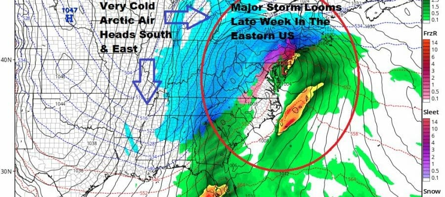
The week ahead will start quietly with no issues through at least Wednesday. Monday Tuesday and Wednesday should be three days of no worse than partly sunny skies. Temperatures will be close to average with highs in the upper 30s to around or just over 40 each day and nights in the 20s. The table is being set for a major storm in the Eastern US late week and that will be followed by a blast of very cold arctic air in time for Christmas Even into Christmas Day. This we know. What we don’t know yet is how we get there with this developing storm and whether we will see snow sleet rain or all of the above along with wind issues. Track remains highly uncertain as models continue to have a difficult time handling this very strong system diving into the Plains later this week as well as the strong blocking pattern that continues in the North Atlantic. Models will likely continue to dance around for the rest of the weekend so we probably will have to wait until Monday to map out a plan for where this all goes.
BE SURE TO DOWNLOAD THE FREE METEOROLOGIST JOE CIOFFI WEATHER APP &
ANGRY BEN’S FREE WEATHER APP “THE ANGRY WEATHERMAN!
MANY THANKS TO TROPICAL TIDBITS & F5 WEATHER FOR THE USE OF MAPS
Please note that with regards to any severe weather, tropical storms, or hurricanes, should a storm be threatening, please consult your local National Weather Service office or your local government officials about what action you should be taking to protect life and property.


