Dry Weather into Mid Week Before Major Storm Develops
Bringing Wind Rain Very Cold Air Late Week

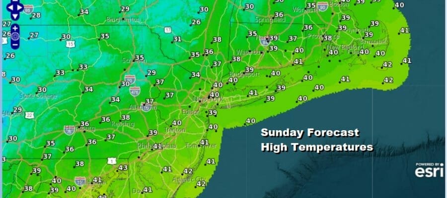
Our relatively quiet weekend of weather continues now that we sit between a storm well to the northeast and a storm system that isn’t even on the map yet. Today will be a typical mid December day with clouds and some sunshine along with a breeze and temperatures that will be topping out in the 30s to around 40 degrees. That is actually a little bit below average but not by much. Tonight we have no issues either with mainly clear skies and most lows in the 20s to near 30 except for a few upper teens in the coldest inland spots. Radars are quiet along the coast though there some snow showers going on in parts of Upstate NY and in Pennsylvania.
SATELLITE

WEATHER RADAR

It is a quiet start to the week ahead and that means we will be dry and calm through Wednesday. A weak cold front will be passing through late Wednesday but you will hardly notice it. It does start the set up for the late week storm which we will get to in a moment but we have Monday Tuesday and Wednesday which will feature three days of some sunshine and afternoon highs mostly in the 30s to around 40 degrees. This is the easy part of the forecast.
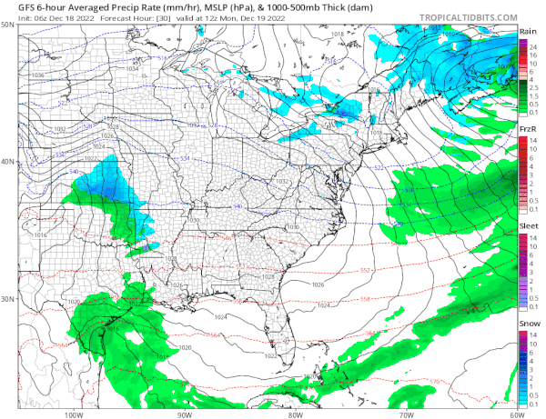
Two systems are in play for late in the week. First we have a weak low that forms along the Southeast coast and this bring a surge of moisture Thursday. If it comes in fast enough there could be a quick burst of snow and sleet before it goes to rain. This develops from south to north Thursday morning to midday and then ends from south to north in the late evening to the early morning hours Friday. While that is going on we see a low developing out of the Plains that heads east into the Ohio Valley and strengthens. This storm will be become a major storm as it heads from there into Upstate NY Friday. Another round of rain is likely Friday as the cold front from this storm passes through. What develops ahead of it will be strong south winds and what follows will be howling west to northwest winds as cold air rushes in behind it.
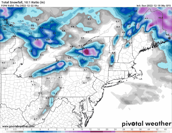
As far as snow is concerned this storm will be a big snow producers for places like Indianapolis, Saint Louis, Chicago, Detroit with lower but still substantial amounts for Western NY and Central Pennsylvania and parts of Ohio. Also we could see a solid burst of snow for areas well north in NY and Northern New England. The bigger issue likely will be the wind late Friday and Friday night behind the storm where we could see widespread wind gusts of 50 mph or more. We will get more specific on how this all transpires in the coming days. Once this storm is done it turns very cold into Christmas weekend which likely will be dry.
BE SURE TO DOWNLOAD THE FREE METEOROLOGIST JOE CIOFFI WEATHER APP &
ANGRY BEN’S FREE WEATHER APP “THE ANGRY WEATHERMAN!
MANY THANKS TO TROPICAL TIDBITS & F5 WEATHER FOR THE USE OF MAPS
Please note that with regards to any severe weather, tropical storms, or hurricanes, should a storm be threatening, please consult your local National Weather Service office or your local government officials about what action you should be taking to protect life and property.


