Ida Hits Hard Tonight With Heavy Rain Severe Weather
Beautiful Weather Follows Into the Weekend

Weather in 5/Joe & Joe Weather Show Latest Podcast
Ida Hits Hard Tonight With Heavy Rain Severe Weather
Beautiful Weather Follows Into the Weekend
So far everything has played out according to plan. Showery rains along the coast have been more of an inconvenience than anything else. Inland from Western New Jersey west and north it has been a continuous rain with numerous flash flood warnings. Now as we head into this evening everything pivots east and we get a 6 to 8 hour shot of heavy rains, thunderstorms and severe weather.
SATELLITE

Radars continue to show the coast from Long Island and NYC southward not doing much but the local and regional radars, especially the Fort Dix radar from Mount Holly NWS is loading up with severe weather with thunderstorms. We have see numerous severe thunderstorm warnings in Maryland and Flash Flood Warnings in Pennsylvania.
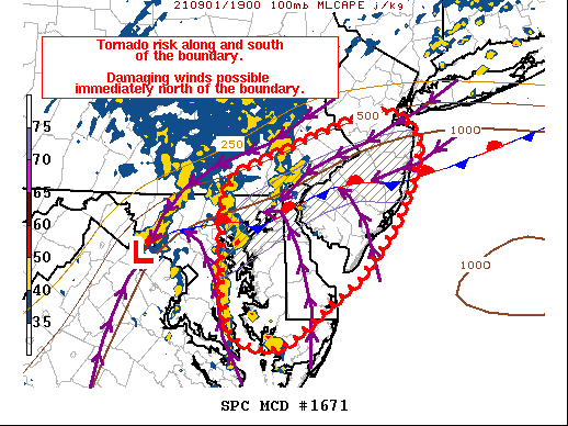
This all will pivot northeastward as the rain shield also pivots to the east. We have also seen a number of tornado warnings in Maryland and SPC is indicating a serious tornado risk for Central and South Jersey this evening.
WEATHER RADAR


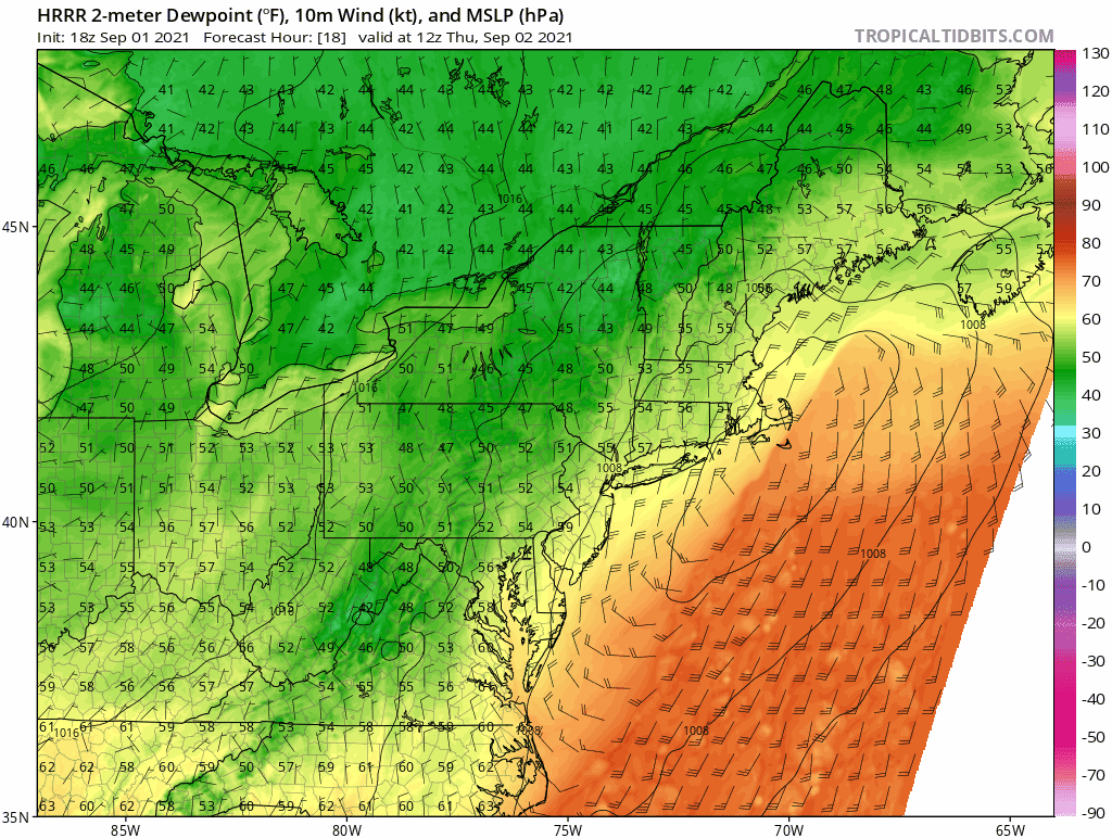
We will follow the action tonight using the HRRR short range model as it seems to be handling this event well. The first frame of the loop is at 5pm and it ends Thursday morning at 7am. The worst of all this will be from 5pm into the early morning hours of Thursday. This is where areas near the coast will see the worst of it with thunderstorms, some severe, and some tornadoes are possible. While wind as a whole is not an issue from the storm, it is an issue with severe thunderstorms and gusts over 60 mph are likely in some thunderstorms as they go by. All of this gets out of here and will be all gone by sunup. it actually ends after midnight in western areas and last in Eastern Long Island and Eastern Connecticut. The Hudson Valley and Northern New Jersey will bear the brunt of heavy rains this evening and tonight but other areas too will see torrential downpours.
Thursday sees dry air with very low dew points rapidly moving in on the back side. We will see increasing sunshine and low humidity with a gusty north breeze and highs in the low to mid 70s Thursday. Friday looks great with sunshine and highs again will be just in the low to mid 70s. Overall the weekend is looking good. Saturday will likely be the best of the three weekend days with sunshine. Sunday some scattered showers are possible early and again late in the day as a weather front moves through and then Monday looks to be dry.
BE SURE TO DOWNLOAD THE FREE METEOROLOGIST JOE CIOFFI WEATHER APP &
ANGRY BEN’S FREE WEATHER APP “THE ANGRY WEATHERMAN!

MANY THANKS TO TROPICAL TIDBITS & F5 WEATHER FOR THE USE OF MAPS
Please note that with regards to any severe weather, tropical storms, or hurricanes, should a storm be threatening, please consult your local National Weather Service office or your local government officials about what action you should be taking to protect life and property.


