Hurricane Nicole Hurricane Warnings Bermuda
Hurricane Nicole Hurricane Warnings Bermuda

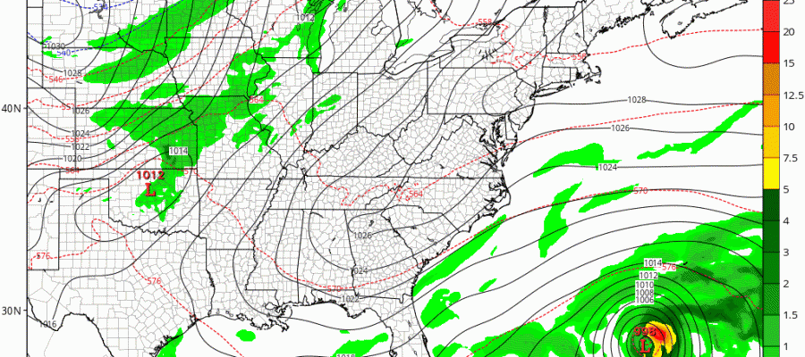
Satellite loops this afternoon show that Nicole has reached hurricane strength again with maximum sustained winds of 75 mph and further strengthening is forecast. Hurricane Warnings are now up for Bermuda as Hurricane Nicole makes its way northward toward the island.

BULLETIN
HURRICANE NICOLE INTERMEDIATE ADVISORY NUMBER  30A
NWS NATIONAL HURRICANE CENTER MIAMI FL       AL152016
200 PM AST TUE OCT 11 2016

...NICOLE BECOMES A HURRICANE AGAIN, HURRICANE WARNING ISSUED FOR
BERMUDA...


SUMMARY OF 200 PM AST...1800 UTC...INFORMATION
----------------------------------------------
LOCATION...27.3N 66.3W
ABOUT 355 MI...575 KM SSW OF BERMUDA
MAXIMUM SUSTAINED WINDS...75 MPH...120 KM/H
PRESENT MOVEMENT...NW OR 325 DEGREES AT 5 MPH...7 KM/H
MINIMUM CENTRAL PRESSURE...982 MB...29.00 INCHES


WATCHES AND WARNINGS
--------------------
CHANGES WITH THIS ADVISORY:

The Bermuda Weather Service has issued a Hurricane Warning for
Bermuda.

SUMMARY OF WATCHES AND WARNINGS IN EFFECT:

A Hurricane Warning is in effect for...
* Bermuda

A Hurricane Warning means that hurricane conditions are expected
somewhere within the warning area.  A warning is typically issued
36 hours before the anticipated first occurrence of
tropical-storm-force winds, conditions that make outside
preparations difficult or dangerous.  Preparations to protect life
and property should be rushed to completion.

For storm information specific to your area, please monitor
products issued by your national meteorological service.


DISCUSSION AND 48-HOUR OUTLOOK
------------------------------
At 200 PM AST (1800 UTC), the center of Tropical Storm Nicole was
located near latitude 27.3 North, longitude 66.3 West. Nicole is
moving toward the northwest near 5 mph (7 km/h). A northwest to
north-northwest motion is expected today. A turn toward the north
and an increase in forward speed is expected tonight, followed by a
northeast turn on Wednesday.  On the forecast track, the center of
Nicole is expected to approach Bermuda Wednesday night and pass near
Bermuda Thursday morning.

Maximum sustained winds have increased to near 75 mph (120 km/h)
with higher gusts. Additional strengthening is forecast during the
next day or two.

Hurricane-force winds extend outward up to 30 miles (45 km) from the
center.  Tropical-storm-force winds extend outward up to 105 miles
(165 km) from the center.

The minimum central pressure reported by an Air Force Reserve
reconnaissance aircraft is 982 mb (29.00 inches).


HAZARDS AFFECTING LAND
----------------------
STORM SURGE: A dangerous storm surge is expected to produce coastal
flooding in Bermuda.  Near the coast, the surge will be accompanied
by large and destructive waves.

WIND: Hurricane conditions are expected to begin on Bermuda
by Wednesday night, with tropical storm conditions beginning
Wednesday afternoon.

RAINFALL:  Nicole is expected to produce total rain accumulations
of 3 to 5 inches over Bermuda through Thursday.

SURF:  Swells associated with Nicole will affect Bermuda during the
next few days.  These swells will create dangerous surf conditions
and rip currents. Please refer to products being issued by the
Bermuda Weather Service
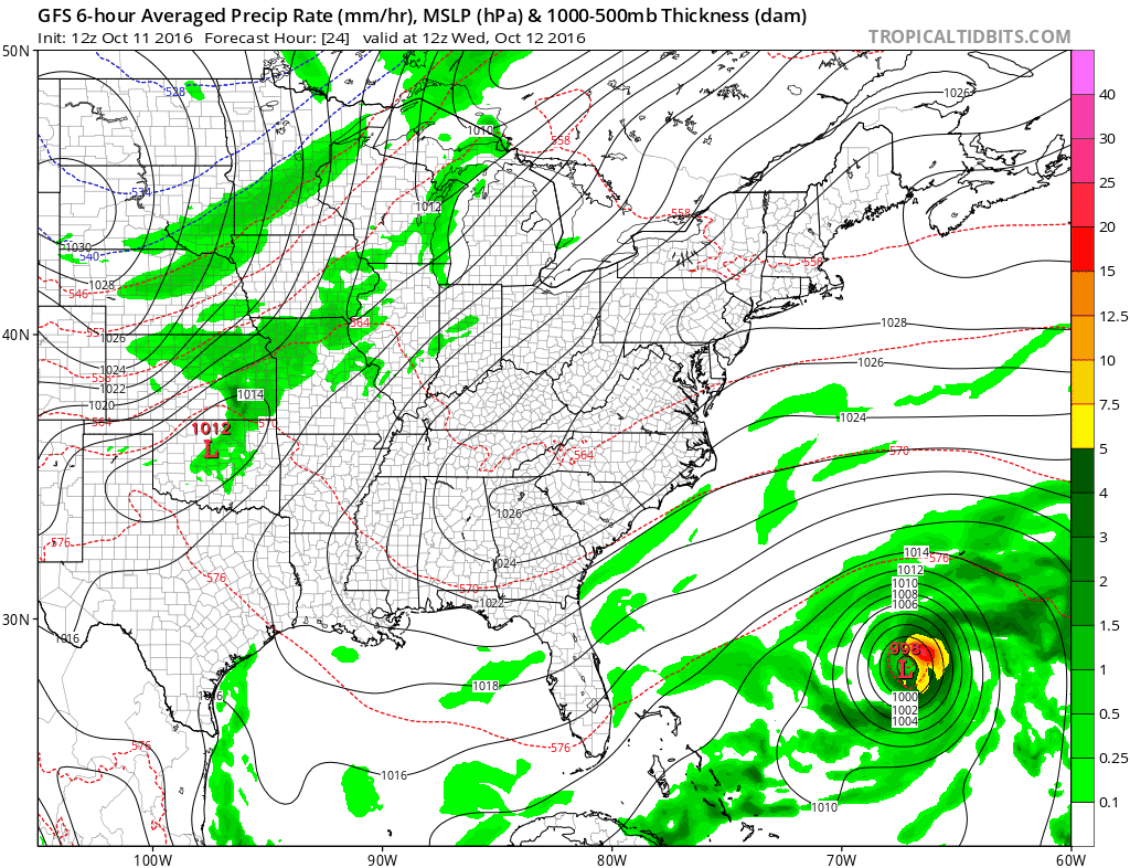
The latest GFS model run takes Nicole very close to Bermuda Wednesday night into Thursday morning. We will have more on Hurricane Nicole this evening.
WINTER 2016-2017 PART 1 OCEAN WATER TEMPERATURES
WINTER 2016-2017 PART 2 ARCTIC SEA ICE AND SIBERIAN SNOW COVER
WINTER 2016-2017 PART 3 NEW JERSEY PREVIEW
WINTER 2016-2017 PART 4 EASTERN PENNSYLVANIA PREVIEW
FiOS1 News Weather Forecast For Long Island
FiOS1 News Weather Forecast For New Jersey
FiOS1 News Weather Forecast For Hudson Valley
NATIONAL WEATHER SERVICE SNOW FORECASTS
LATEST JOESTRADAMUS ON THE LONG RANGE
Weather App

Don’t be without Meteorologist Joe Cioffi’s weather app. It is really a meteorologist app because you get my forecasts and my analysis and not some automated computer generated forecast based on the GFS model. This is why your app forecast changes every 6 hours. It is model driven with no human input at all. It gives you an icon, a temperature and no insight whatsoever.
It is a complete weather app to suit your forecast needs. All the weather information you need is right on your phone. Android or I-phone, use it to keep track of all the latest weather information and forecasts. This weather app is also free of advertising so you don’t have to worry about security issues with your device. An accurate forecast and no worries that your device is being compromised.
Use it in conjunction with my website and my facebook and twitter and you have complete weather coverage of all the latest weather and the long range outlook. The website has been redone and upgraded. Its easy to use and everything is archived so you can see how well Joe does or doesn’t do when it comes to forecasts and outlooks.
Just click on the google play button or the apple store button on the sidebar for my app which is on My Weather Concierge. Download the app for free. Subscribe to my forecasts on an ad free environment for just 99 cents a month.
Get my forecasts in the palm of your hand for less than the cost of a cup of Joe!
![]()
![]()