Hurricane Milton Category 4 Heads For Florida Landfall
While Northeast Mid Atlantic Enjoy Sunny Autumn Weather

Hurricane Milton Category 4 Heads For Florida Landfall
While Northeast Mid Atlantic Enjoy Sunny Autumn Weather
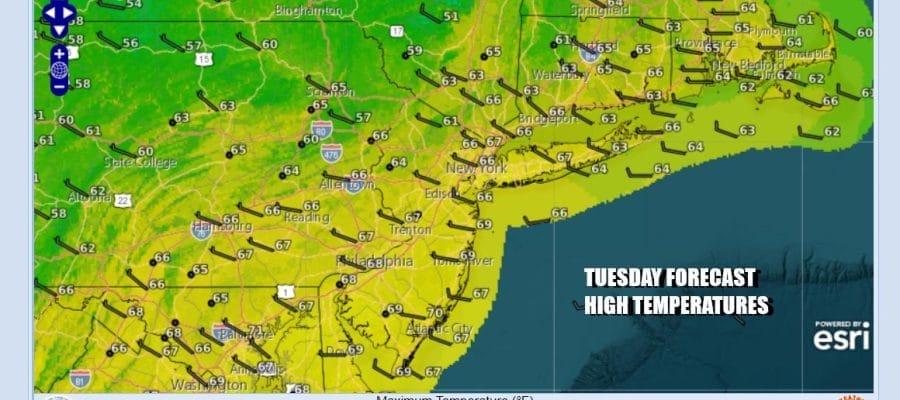
An Autumn air mass in the form of high pressure is spreading across the Great Lakes, Ohio Valley and Northeast for the next several days. The high will keep Hurricane Milton from moving up the US East Coast. Satellite loops show mostly cloud free conditions so expect sunshine with nothing more than a few passing clouds today. Radars are nice and quiet and will be on vacation for the rest of the week. High temperatures this afternoon will be mostly in the 60s. Chilly nights lie ahead with clear skies tonight and Wednesday morning lows will be in the 40s inland, near 50 coast and warmer urban areas, and a few 30s in the coldest spots inland.
SATELLITE WITH LIGHTNING STRIKES

WEATHER RADAR

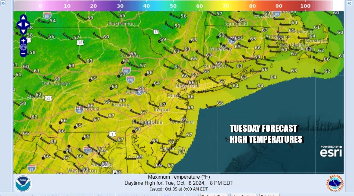
We see no weather issues for Wednesday and for that matter the rest of the week and probably the weekend. The upper flow from Canada is a strong one and we have one cool air mass followed by an even chillier air mass for next week. The cold front with this new colder air mass will approach late Sunday or Sunday night and at worst there might be a passing shower.

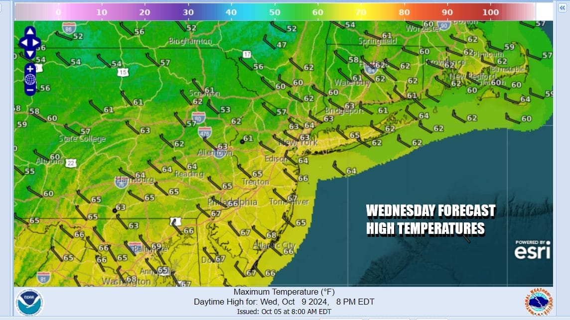
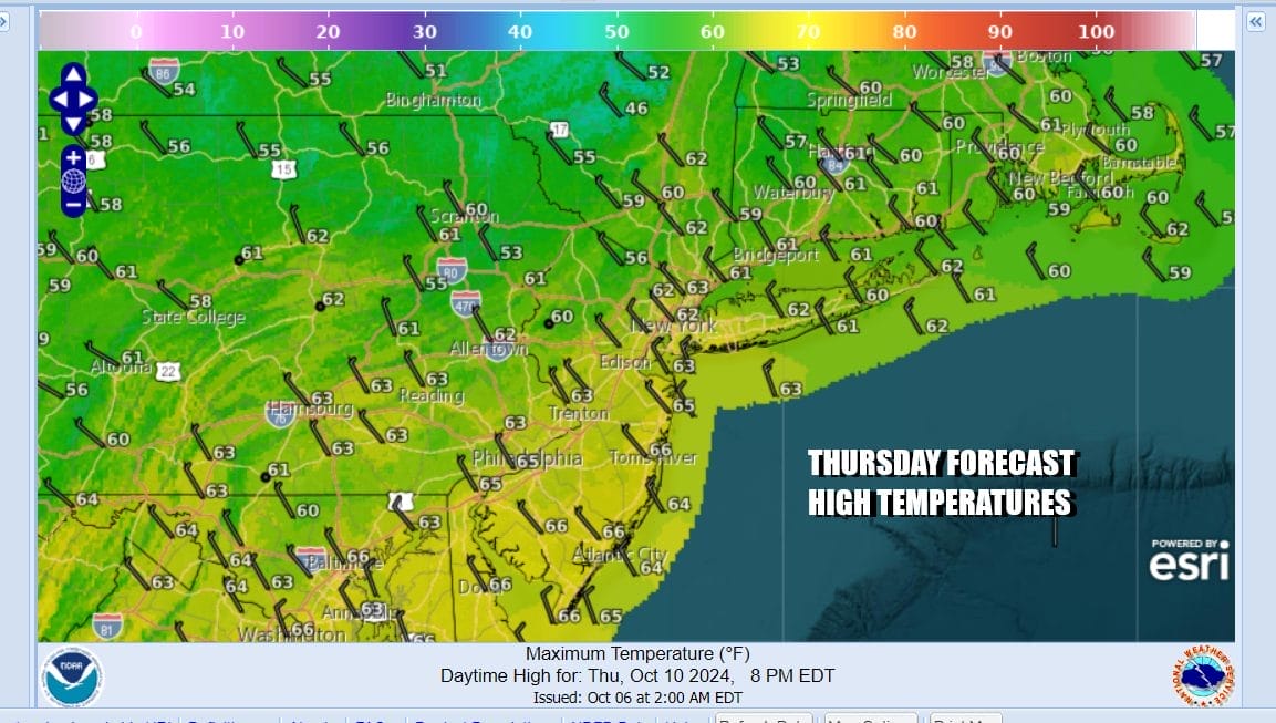
In the meantime we have Wednesday which will be a day of sunshine and some passing clouds. Most highs will be in the low and middle 60s. Wednesday night into Thursday morning will be nice and clear with lows in the 40s just about everywhere with some 30s in the coldest spots well north and northwest of Philadelphia and NYC. Thursday we continue to see lots of sunshine with highs in the low to mid 60s and then another chilly night into Friday morning.
We will finish the work week with a sunny Friday and highs in the mid to upper 60s. The weekend looks to be warm for Saturday with sunshine and highs back in the 70s. Sunday we will see sun and arriving clouds with highs in the upper 60s to mid 70s ahead of that cold front mentioned earlier. Next week we will probably see the coldest air of the season so far and probably the first frosts for inland areas.

Major Hurricane Milton will continue to target a Florida west coast landfall late Wednesday into Wednesday night. It appears that we have seen the peak intensity yesterday but Milton will be a formidable category 3 hurricane (or possibly a low end 4) at landfall. Weather models have been focusing on a track from Tampa Bay and the along the I-4 Corridor to Orlando and Daytona and we don’t see any reason to change on this idea though we could be subject to wobbles in the forecast track in either direction.
BE SURE TO DOWNLOAD THE FREE METEOROLOGIST JOE CIOFFI WEATHER APP &
ANGRY BEN’S FREE WEATHER APP “THE ANGRY WEATHERMAN!
MANY THANKS TO TROPICAL TIDBITS FOR THE USE OF MAPS
Please note that with regards to any severe weather, tropical storms, or hurricanes, should a storm be threatening, please consult your local National Weather Service office or your local government officials about what action you should be taking to protect life and property.
(Amazon is an affilate of Meteorologist Joe Cioffi & earns commissions on sales.)


