Hurricane Matthew Watches For Florida
Hurricane Matthew Watches For Florida Extended Southward
Hurricane Matthew is heading toward Eastern Cuba and will make landfall sometime tonight. Meanwhile to the east northeast is Tropical Storm Nicole which may or may not have a say in where Hurricane Matthew winds up. And we have disorganized disturbed weather approaching the Windward Islands.
I guess the only thing we are sure of this point is where Matthew is right now. Here are the latest advisories for both Matthew & Nicole.
HURRICANE MATTHEW ADVISORY NUMBER  27
NWS NATIONAL HURRICANE CENTER MIAMI FL       AL142016
500 PM EDT TUE OCT 04 2016

...NORTHERN EYEWALL OF EXTREMELY DANGEROUS HURRICANE MATTHEW
ALREADY POUNDING THE EASTERN TIP OF CUBA...


SUMMARY OF 500 PM EDT...2100 UTC...INFORMATION
----------------------------------------------
LOCATION...19.8N 74.3W
ABOUT 65 MI...105 KM ESE OF GUANTANAMO CUBA
ABOUT 30 MI...45 KM SSW OF THE EASTERN TIP OF CUBA
MAXIMUM SUSTAINED WINDS...140 MPH...220 KM/H
PRESENT MOVEMENT...N OR 360 DEGREES AT 9 MPH...15 KM/H
MINIMUM CENTRAL PRESSURE...949 MB...28.03 INCHES


WATCHES AND WARNINGS
--------------------
CHANGES WITH THIS ADVISORY:

The Hurricane Watch has been extended southward to Golden Beach,
Florida.

SUMMARY OF WATCHES AND WARNINGS IN EFFECT:

A Hurricane Warning is in effect for...
* Haiti
* Cuban provinces of Guantanamo, Santiago de Cuba, Holguin, Granma,
and Las Tunas
* Southeastern Bahamas, including the Inaguas, Mayaguana, Acklins,
Crooked Island, Long Cay, and Ragged Island
* Central Bahamas, including Long Island, Exuma, Rum Cay,
San Salvador, and Cat Island
* Northwestern Bahamas, including the Abacos, Andros Island,
Berry Islands, Bimini, Eleuthera, Grand Bahama Island, and
New Providence

A Hurricane Watch is in effect for...
* Cuban province of Camaguey
* Golden Beach to the Volusia/Brevard county line

A Tropical Storm Warning is in effect for...
* Dominican Republic from Barahona westward to the border with Haiti
* Turks and Caicos Islands

A Tropical Storm Watch is in effect for...
* Dominican Republic from Puerto Plata westward to the border with
Haiti
* Seven Mile Bridge to south of Golden Beach
* Lake Okeechobee

Interests elsewhere in the Florida Peninsula and the Florida Keys
should monitor the progress of Matthew.

For storm information specific to your area in the United States,
including possible inland watches and warnings, please monitor
products issued by your local National Weather Service forecast
office. For storm information specific to your area outside the
United States, please monitor products issued by your national
meteorological service.


DISCUSSION AND 48-HOUR OUTLOOK
------------------------------
At 500 PM EDT (2100 UTC), the eye of Hurricane Matthew was located
near latitude 19.8 North, longitude 74.3 West.  Matthew is moving
toward the north near 9 mph (15 km/h). On this track the eye of
Matthew will move over the extreme portion of eastern Cuba in the
next few hours.  A turn toward the north-northwest is expected by
Wednesday, followed by a northwest turn Wednesday night. Matthew is
expected to move near or over portions of the southeastern and
central Bahamas tonight and Wednesday, and approach the northwestern
Bahamas Wednesday night.

Maximum sustained winds are near 140 mph (220 km/h) with higher
gusts.  Matthew is a category 4 hurricane on the Saffir-Simpson
Hurricane Wind Scale.  Some fluctuations in intensity are possible
during the next couple of days, but Matthew is expected to remain a
powerful hurricane through at least Thursday night.

Hurricane-force winds extend outward up to 45 miles (75 km) from the
center and tropical-storm-force winds extend outward up to 175 miles
(280 km).

The estimated minimum central pressure is 949 mb (28.03 inches).
BULLETIN
TROPICAL STORM NICOLE ADVISORY NUMBER   2
NWS NATIONAL HURRICANE CENTER MIAMI FL       AL152016
500 PM AST TUE OCT 04 2016

...NICOLE CONTINUES MOVING NORTHWESTWARD WITH LITTLE CHANGE IN
STRENGTH...


SUMMARY OF 500 PM AST...2100 UTC...INFORMATION
----------------------------------------------
LOCATION...24.1N 61.1W
ABOUT 510 MI...820 KM NE OF SAN JUAN PUERTO RICO
MAXIMUM SUSTAINED WINDS...50 MPH...85 KM/H
PRESENT MOVEMENT...NW OR 305 DEGREES AT 9 MPH...15 KM/H
MINIMUM CENTRAL PRESSURE...1005 MB...29.68 INCHES


WATCHES AND WARNINGS
--------------------
There are no coastal watches or warnings in effect.


DISCUSSION AND 48-HOUR OUTLOOK
------------------------------
At 500 PM AST (2100 UTC), the center of Tropical Storm Nicole was
located near latitude 24.1 North, longitude 61.1 West.  Nicole is
moving toward the northwest near 9 mph (15 km/h), and this general
motion is expected to continue over the next 48 hours.

Maximum sustained winds are near 50 mph (85 km/h) with higher gusts.
Little change in strength is forecast for the next day or so,
followed by gradual weakening.

Tropical-storm-force winds extend outward up to 70 miles (110 km)
from the center.

The estimated minimum central pressure is 1005 mb (29.68 inches).


HAZARDS AFFECTING LAND
----------------------
None.
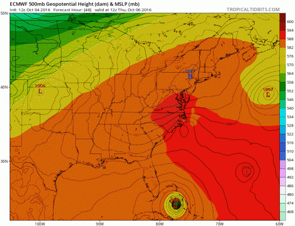
For those of you who like the European Model take a look at today’s model run. It actually takes the storm over Miami twice!
HURRICANE MATTHEW EUROPEAN WEATHER MODEL CLICK TO ANIMATE
This was one of a dozen different solutions offered by this afternoon’s weather model run. The confusion only increases. The trough to the north is so flat that it completely misses Hurricane Matthew and then as a ridge build to northeast of Matthew, the hurricane is forced to loop and then turn south and southwestward back to Florida!
We can only keep deferring to the next model cycle.
WINTER 2016-2017 PART 1 OCEAN WATER TEMPERATURES
WINTER 2016-2017 PART 2 ARCTIC SEA ICE AND SIBERIAN SNOW COVER
WINTER 2016-2017 PART 3 NEW JERSEY PREVIEW
WINTER 2016-2017 PART 4 EASTERN PENNSYLVANIA PREVIEW
FiOS1 News Weather Forecast For Long Island
FiOS1 News Weather Forecast For New Jersey
FiOS1 News Weather Forecast For Hudson Valley
NATIONAL WEATHER SERVICE SNOW FORECASTS
LATEST JOESTRADAMUS ON THE LONG RANGE
Weather App
Don’t be without Meteorologist Joe Cioffi’s weather app. It is really a meteorologist app because you get my forecasts and my analysis and not some automated computer generated forecast based on the GFS model. This is why your app forecast changes every 6 hours. It is model driven with no human input at all. It gives you an icon, a temperature and no insight whatsoever.
It is a complete weather app to suit your forecast needs. All the weather information you need is right on your phone. Android or I-phone, use it to keep track of all the latest weather information and forecasts. This weather app is also free of advertising so you don’t have to worry about security issues with your device. An accurate forecast and no worries that your device is being compromised.
Use it in conjunction with my website and my facebook and twitter and you have complete weather coverage of all the latest weather and the long range outlook. The website has been redone and upgraded. Its easy to use and everything is archived so you can see how well Joe does or doesn’t do when it comes to forecasts and outlooks.
Just click on the google play button or the apple store button on the sidebar for my app which is on My Weather Concierge. Download the app for free. Subscribe to my forecasts on an ad free environment for just 99 cents a month.
Get my forecasts in the palm of your hand for less than the cost of a cup of Joe!


