Hurricane Matthew Strengthens Category 3 Hurricane
Hurricane Matthew Strengthens Category 3 Hurricane
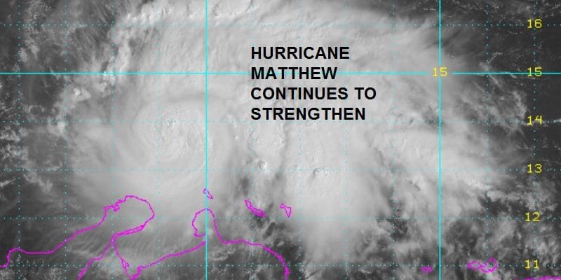
Reports from an Air Force Reconnaissance plane this morning show that Hurricane Matthew continues to strengthen rather rapidly with pressures continuing to drop at about 1 to 2 mb per hour. The plane reported a flight level wind of 103 kts and a pressure of 969 mb. What has been really impressive about this hurricane is that it has been able to strengthen even though there is a bit of wind shear going on. Apparently other factors are more than over compensating for this. Also Hurricane Matthew continues to become more circular and symetrical which is an indicator of a strong hurricane developing.

There was an eye that became visible overnight but it has since disappeared. You can see it appear and quickly disappear. A new eye should be forming soon as the strengthening trend continues.

BULLETIN
HURRICANE MATTHEW ADVISORY NUMBER  10
NWS NATIONAL HURRICANE CENTER MIAMI FL       AL142016
1100 AM EDT FRI SEP 30 2016

...MATTHEW STRENGTHENS TO A MAJOR HURRICANE WHILE MOVING WEST-
SOUTHWESTWARD OVER THE CARIBBEAN SEA...


SUMMARY OF 1100 AM EDT...1500 UTC...INFORMATION
-----------------------------------------------
LOCATION...13.7N 70.8W
ABOUT 105 MI...170 KM NE OF PUNTA GALLINAS COLOMBIA
ABOUT 495 MI...800 KM SE OF KINGSTON JAMAICA
MAXIMUM SUSTAINED WINDS...115 MPH...185 KM/H
PRESENT MOVEMENT...WSW OR 255 DEGREES AT 12 MPH...19 KM/H
MINIMUM CENTRAL PRESSURE...968 MB...28.59 INCHES


WATCHES AND WARNINGS
--------------------
CHANGES WITH THIS ADVISORY:

The government of Colombia has changed the Tropical Storm Watch
that was in effect from the Colombia/Venezuela border to Riohacha
to a Tropical Storm Warning.

The government of Aruba has discontinued the Tropical Storm Watch
for Aruba.

SUMMARY OF WATCHES AND WARNINGS IN EFFECT:

A Tropical Storm Warning is in effect for...
* Colombia/Venezuela border to Riohacha

A Tropical Storm Warning means that tropical storm conditions are
expected somewhere within the warning area, in this case in the
next 12 to 24 hours.

Interests elsewhere along the coasts of Venezuela and Colombia
should monitor the progress of Matthew.  Interests in Jamaica,
Hispaniola, and eastern Cuba should also monitor the progress of
Matthew.  A hurricane watch may be required for Jamaica later today.

For storm information specific to your area, please monitor products
issued by your national meteorological service.


DISCUSSION AND 48-HOUR OUTLOOK
------------------------------
At 1100 AM EDT (1500 UTC), the center of Hurricane Matthew was
located near latitude 13.7 North, longitude 70.8 West.  Matthew is
moving toward the west-southwest near 12 mph (19 km/h).  A westward
motion at a slower forward speed is expected later today and
tonight.  A turn toward the west-northwest is forecast by Saturday
night, followed by a turn toward the northwest by early Sunday.  On
the forecast track, the center of Matthew will pass north of the
Guajira Peninsula later today and tonight and remain over the
central Caribbean Sea through early Sunday.

Data from an Air Force Reserve Hurricane Hunter aircraft indicate
that maximum sustained winds have increased to near 115 mph (185
km/h) with higher gusts.  Matthew is a category 3 hurricane on the
Saffir-Simpson Hurricane Wind Scale.  Little change in strength is
forecast during the next 48 hours.

Hurricane-force winds extend outward up to 35 miles (55 km) from the
center and tropical-storm-force winds extend outward up to 195 miles
(315 km).

The latest minimum central pressure based on data from the aircraft
is 968 mb (28.59 inches).


HAZARDS AFFECTING LAND
----------------------
WIND:  Tropical storm conditions are expected in portions of the
warning area in Colombia later later today and tonight.

RAINFALL:  Rainfall totals of 2 to 4 inches with isolated higher
amounts are expected over Aruba, Bonaire and Curacao through
Saturday.  Rainfall totals of 2 to 4 inches with isolated higher
amounts are expected along the coast of Colombia from the Venezuelan
border to Riohacha.  Rainfall totals of 1 to 2 inches with isolated
higher amounts are expected along the coast of Venezuela from Coro
to the Colombian border.

SURF:  Swells generated by Matthew are expected to affect portions
of the coasts of Puerto Rico, Hispaniola, Aruba, Bonaire, Curacao,
Venezuela, and Colombia during the next few days.  These swells are
likely to cause life-threatening surf and rip current conditions.
Please consult products from your local weather office.
WINTER 2016-2017 PART 1 OCEAN WATER TEMPERATURES
WINTER 2016-2017 PART 2 ARCTIC SEA ICE AND SIBERIAN SNOW COVER
WINTER 2016-2017 PART 3 NEW JERSEY PREVIEW
WINTER 2016-2017 PART 4 EASTERN PENNSYLVANIA PREVIEW
FiOS1 News Weather Forecast For Long Island
FiOS1 News Weather Forecast For New Jersey
FiOS1 News Weather Forecast For Hudson Valley
NATIONAL WEATHER SERVICE SNOW FORECASTS
LATEST JOESTRADAMUS ON THE LONG RANGE
Weather App

Don’t be without Meteorologist Joe Cioffi’s weather app. It is really a meteorologist app because you get my forecasts and my analysis and not some automated computer generated forecast based on the GFS model. This is why your app forecast changes every 6 hours. It is model driven with no human input at all. It gives you an icon, a temperature and no insight whatsoever.
It is a complete weather app to suit your forecast needs. All the weather information you need is right on your phone. Android or I-phone, use it to keep track of all the latest weather information and forecasts. This weather app is also free of advertising so you don’t have to worry about security issues with your device. An accurate forecast and no worries that your device is being compromised.
Use it in conjunction with my website and my facebook and twitter and you have complete weather coverage of all the latest weather and the long range outlook. The website has been redone and upgraded. Its easy to use and everything is archived so you can see how well Joe does or doesn’t do when it comes to forecasts and outlooks.
Just click on the google play button or the apple store button on the sidebar for my app which is on My Weather Concierge. Download the app for free. Subscribe to my forecasts on an ad free environment for just 99 cents a month.
Get my forecasts in the palm of your hand for less than the cost of a cup of Joe!
![]()
![]()