Hurricane Matthew No Worries Through Friday
Hurricane Matthew No Worries Through Friday
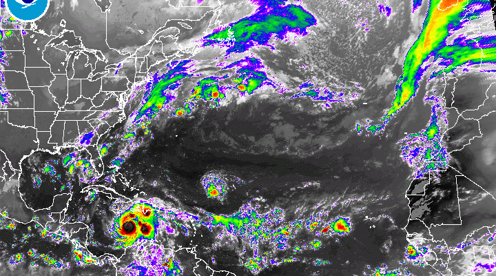
After looking at all the overnight models we can safely say that there are no worries regarding Hurricane Matthew for the rest of the work week. It will not be until later in the day Saturday that weather conditions begin to deteriorate in Southern areas of New Jersey and Southeastern Pennsylvania, and later Saturday night into much of Sunday from Northern New Jersey and New York City. I am also becoming more and more convinced that Hurricane Matthew will be making the transition over to a post tropical cyclone by the time it reaches our latitude which means that it will begin to take on the characteristics of a noreaster and possibly a rather fierce one. We will discuss more about Hurricane Matthew later this morning.

We have some low cloud issues again this morning however there is enough dry air in New England that is buliding southward that we should see partly sunny skies developing later today in some areas. Others may see the low clouds begin a bit stubborn.

Radars this morning are fairly quiet. There were a few isolated sprinkles showing up here and there but that should disappear before mid morning. Temperatures today will be mostly in the 60s.


High pressure builds down from the north for the rest of the week. The cloud line should shift southward for Wednesday into Friday so we should see a fair amount of sunshine. Temperatures will be in the 60s again on Wednesday but should warm into the 70s Thursday and Friday.

Then of course the weekend hinges on Hurricane Matthew and the final track up the east coast. JOESTRADAMUS looked at the weather models last night and has this post on the GFS model and UKMET model
WINTER WEATHER OUTLOOK VIDEOS
In case you missed them I’ve been previewing the upcoming winter in a series of posts and videos. Here are the first 2. More will be coming along. Links to the latest posts are below.
NEW JERSEY
LONG ISLAND AND NEARBY
WINTER 2016-2017 PART 3 NEW JERSEY
WINTER 2016-2017 PART 1 OCEAN WATER TEMPERATURES
WINTER 2016-2017 PART 2 ARCTIC SEA ICE AND SIBERIAN SNOW COVER
FiOS1 News Weather Forecast For Long Island
FiOS1 News Weather Forecast For New Jersey
FiOS1 News Weather Forecast For Hudson Valley
NATIONAL WEATHER SERVICE SNOW FORECASTS
LATEST JOESTRADAMUS ON THE LONG RANGE

Weather App

Don’t be without Meteorologist Joe Cioffi’s weather app. It is really a meteorologist app because you get my forecasts and my analysis and not some automated computer generated forecast based on the GFS model. This is why your app forecast changes every 6 hours. It is model driven with no human input at all. It gives you an icon, a temperature and no insight whatsoever.
It is a complete weather app to suit your forecast needs. All the weather information you need is right on your phone. Android or I-phone, use it to keep track of all the latest weather information and forecasts. This weather app is also free of advertising so you don’t have to worry about security issues with your device. An accurate forecast and no worries that your device is being compromised.
Use it in conjunction with my website and my facebook and twitter and you have complete weather coverage of all the latest weather and the long range outlook. The website has been redone and upgraded. Its easy to use and everything is archived so you can see how well Joe does or doesn’t do when it comes to forecasts and outlooks.
Just click on the google play button or the apple store button on the sidebar for my app which is on My Weather Concierge. Download the app for free. Subscribe to my forecasts on an ad free environment for just 99 cents a month.
Get my forecasts in the palm of your hand for less than the cost of a cup of Joe!

MENTION JOE CIOFFI AND GET A 5% DISCOUNT


