Hurricane Matthew Florida Bound
Hurricane Matthew Florida Bound
Hurricane Warnings Extended Northward
Hurricane Watch Georgia & South Carolina Coast

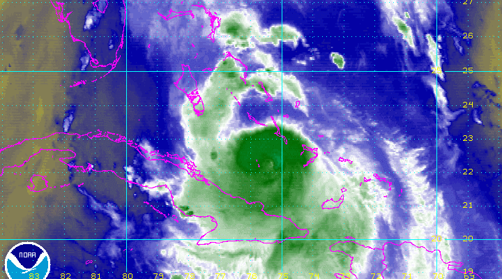
The latest water vapor loop is showing a distinct eye developing again. The circulation of Hurricane Matthew continues to pull away from Cuba and Haiti. It is now over 86 degree plus water and a low wind shear environment. Strengthening is possible from now until it reaches Florida.

HURRICANE MATTHEW FLORIDA BOUND 11PM ADVISORY
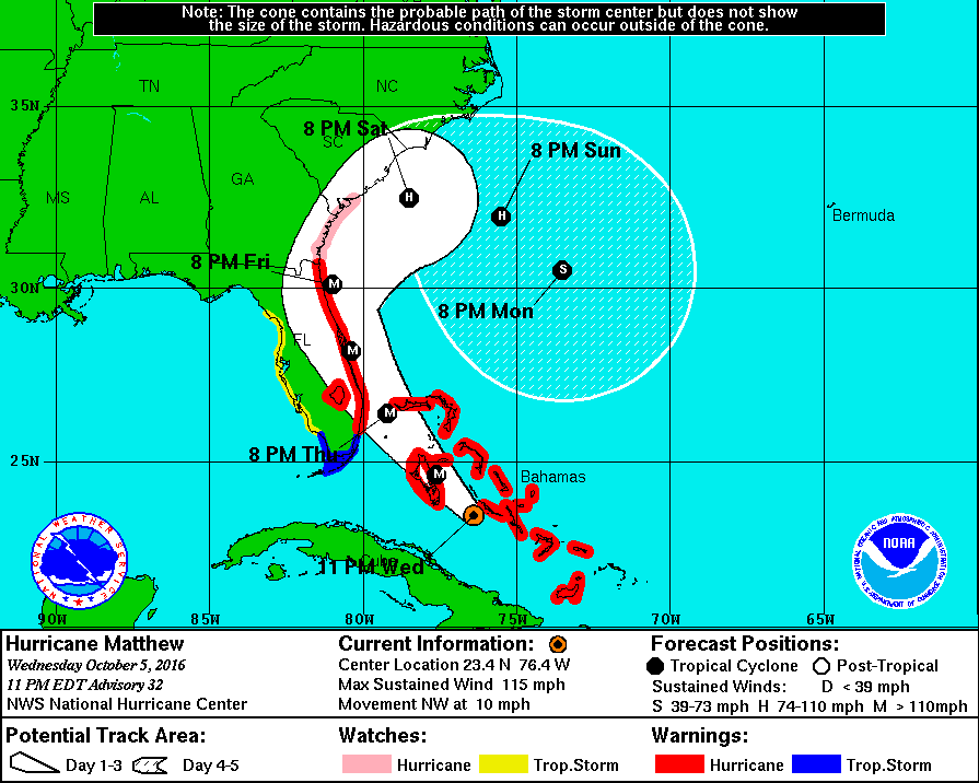
BULLETIN
HURRICANE MATTHEW ADVISORY NUMBER  32
NWS NATIONAL HURRICANE CENTER MIAMI FL       AL142016
1100 PM EDT WED OCT 05 2016

...EYE OF MATTHEW MOVING NEAR THE CENTRAL BAHAMAS...
...EXPECTED TO INTENSIFY AS IT APPROACHES FLORIDA...


SUMMARY OF 1100 PM EDT...0300 UTC...INFORMATION
-----------------------------------------------
LOCATION...23.4N 76.4W
ABOUT 125 MI...205 KM SSE OF NASSAU
ABOUT 325 MI...525 KM SE OF WEST PALM BEACH FLORIDA
MAXIMUM SUSTAINED WINDS...115 MPH...185 KM/H
PRESENT MOVEMENT...NW OR 320 DEGREES AT 10 MPH...17 KM/H
MINIMUM CENTRAL PRESSURE...961 MB...28.38 INCHES


WATCHES AND WARNINGS
--------------------
CHANGES WITH THIS ADVISORY:

A Hurricane Warning has been issued north of the Flagler/Volusia
county line to Fernandina Beach, Florida.

A Hurricane Watch has been issued north of Savannah River to Edisto
Beach, South Carolina.

SUMMARY OF WATCHES AND WARNINGS IN EFFECT:

A Hurricane Warning is in effect for...
* Southeastern Bahamas, including the Inaguas, Mayaguana, Acklins,
Crooked Island, Long Cay, and Ragged Island
* Central Bahamas, including Long Island, Exuma, Rum Cay,
San Salvador, and Cat Island
* Northwestern Bahamas, including the Abacos, Andros Island,
Berry Islands, Bimini, Eleuthera, Grand Bahama Island, and
New Providence
* North of Golden Beach to Fernandina Beach
* Lake Okeechobee

A Hurricane Watch is in effect for...
* North of Fernandina Beach to Edisto Beach

A Tropical Storm Warning is in effect for...
* Chokoloskee to Golden Beach
* Florida Keys from Seven Mile Bridge eastward
* Florida Bay

A Tropical Storm Watch is in effect for...
* North of Chokoloskee to Suwannee River

A Hurricane Warning means that hurricane conditions are expected
somewhere within the warning area.  A warning is typically issued
36 hours before the anticipated first occurrence of
tropical-storm-force winds, conditions that make outside
preparations difficult or dangerous.  Preparations to protect life
and property should be rushed to completion.

A Hurricane Watch means that hurricane conditions are possible
within the watch area.  A watch is typically issued 48 hours
before the anticipated first occurrence of tropical-storm-force
winds, conditions that make outside preparations difficult or
dangerous.

A Tropical Storm Watch means that tropical storm conditions are
possible within the watch area, generally within 48 hours.

Interests elsewhere in the Florida Peninsula, the Florida Keys, and
in the Carolinas should monitor the progress of Matthew.

For storm information specific to your area in the United
States, including possible inland watches and warnings, please
monitor products issued by your local National Weather Service
forecast office. For storm information specific to your area outside
the United States, please monitor products issued by your national
meteorological service.


DISCUSSION AND 48-HOUR OUTLOOK
------------------------------
At 1100 PM EDT (0300 UTC), the center of Hurricane Matthew was
located near latitude 23.4 North, longitude 76.4 West. Matthew is
moving toward the northwest near 10 mph (17 km/h) and this general
motion is expected to continue tonight and Thursday.  A turn toward
the north-northwest is expected Thursday night.  On the forecast
track, the center of Matthew should pass near Andros Island and
Nassau overnight, then very near the east coast of the Florida
peninsula Thursday night through Friday night.

Maximum sustained winds are near 115 mph (185 km/h) with higher
gusts.  Matthew is a category 3 hurricane on the Saffir-Simpson
Hurricane Wind Scale.  Strengthening is expected during the next
24-36 hours, and Matthew is forecast to be a category 4 hurricane
as it approaches Florida.

Hurricane-force winds extend outward up to 45 miles (75 km) from the
center and tropical-storm-force winds extend outward up to 175 miles
(280 km).

The estimated minimum central pressure is 961 mb (28.38 inches).


HAZARDS AFFECTING LAND
----------------------
WIND:  Hurricane conditions will continue over the central Bahamas
and spread into the northwestern Bahamas tonight and Thursday.
Winds will gradually diminish over the southeastern Bahamas tonight.

Hurricane conditions are expected to first reach the hurricane
warning area in Florida by late Thursday and will spread northward
Thursday night and Friday.  Tropical storm conditions are first
expected in Florida by early Thursday.

Hurricane conditions are possible in the hurricane watch area in
Georgia and South Carolina by late Friday, with tropical storm
conditions possible on Friday.

Tropical storm conditions are possible in the tropical storm watch
area on the Florida Gulf Coast on Thursday.

STORM SURGE:  The combination of a dangerous storm surge and large
and destructive waves could raise water levels by as much as the
following amounts above normal tide levels...

Northern Coast of Cuba east of Camaguey...1 to 3 feet
The Bahamas...10 to 15 feet

The water could reach the following heights above ground if the peak
surge occurs at the time of high tide...

Sebastian Inlet to Savannah River...5 to 8 ft
Deerfield Beach to Sebastian Inlet...3 to 5 ft
Virginia Key to Deerfield Beach...1 to 2 ft

Surge-related flooding depends on the relative timing of the surge
and the tidal cycle, and can vary greatly over short distances.
Large waves generated by Matthew will cause water rises to occur
well in advance of and well away from the track of the center.

The combination of a dangerous storm surge and the tide will cause
normally dry areas near the coast to be flooded by rising waters
moving inland from the shoreline.  There is a danger of life-
threatening inundation during the next 36 hours along the Florida
east coast from Deerfield Beach to Fernandina Beach.

There is the possibility of life-threatening inundation during the
next 48 hours from north of Fernandina Beach to Edisto Beach.
For a depiction of areas at risk, please see the Prototype National
Weather Service Storm Surge Watch/Warning Graphic. For information
specific to your area, please see products issued by your local
National Weather Service forecast office.

The Prototype Storm Surge Watch/Warning Graphic is a depiction of
areas that would qualify for inclusion under a storm surge watch or
warning currently under development by the National Weather Service
and planned for operational use in 2017.  The Prototype Graphic is
available at hurricanes.gov.

RAINFALL:  Matthew is expected to produce total rainfall amounts in
the following areas:

Eastern Cuba...8 to 12 inches, isolated 20 inches
Central Cuba...3 to 5 inches, isolated 8 inches
The Bahamas...8 to 12 inches, isolated 15 inches
Turks and Caicos Islands...2 to 5 inches, isolated 8 inches
Coastal eastern Florida....4 to 7 inches, isolated 10 inches
Florida Keys....1 to 3 inches, isolated 5 inches

Life-threatening flash floods and mudslides are likely in central
and eastern Cuba.

SURF:  Swells generated by Matthew will continue to affect portions
of the north coast of Cuba and the Bahamas during the next few days,
and will spread northward along the east coast of Florida and the
southeast U.S. coast tonight and Thursday and continue into the
weekend.  These swells are likely to cause life-threatening surf and
rip current conditions.  Please consult products from your local
weather office.
HURRICANE MATTHEW FLORIDA BOUND
LATEST NATIONAL HURRICANE CENTER FORECAST
There has been no major change in the forecast from the National Hurricane Center. New models are beginning their cycle run now.
WINTER 2016-2017 PART 1 OCEAN WATER TEMPERATURES
WINTER 2016-2017 PART 2 ARCTIC SEA ICE AND SIBERIAN SNOW COVER
WINTER 2016-2017 PART 3 NEW JERSEY PREVIEW
WINTER 2016-2017 PART 4 EASTERN PENNSYLVANIA PREVIEW
FiOS1 News Weather Forecast For Long Island
FiOS1 News Weather Forecast For New Jersey
FiOS1 News Weather Forecast For Hudson Valley
NATIONAL WEATHER SERVICE SNOW FORECASTS
LATEST JOESTRADAMUS ON THE LONG RANGE
Weather App

Don’t be without Meteorologist Joe Cioffi’s weather app. It is really a meteorologist app because you get my forecasts and my analysis and not some automated computer generated forecast based on the GFS model. This is why your app forecast changes every 6 hours. It is model driven with no human input at all. It gives you an icon, a temperature and no insight whatsoever.
It is a complete weather app to suit your forecast needs. All the weather information you need is right on your phone. Android or I-phone, use it to keep track of all the latest weather information and forecasts. This weather app is also free of advertising so you don’t have to worry about security issues with your device. An accurate forecast and no worries that your device is being compromised.
Use it in conjunction with my website and my facebook and twitter and you have complete weather coverage of all the latest weather and the long range outlook. The website has been redone and upgraded. Its easy to use and everything is archived so you can see how well Joe does or doesn’t do when it comes to forecasts and outlooks.
Just click on the google play button or the apple store button on the sidebar for my app which is on My Weather Concierge. Download the app for free. Subscribe to my forecasts on an ad free environment for just 99 cents a month.
Get my forecasts in the palm of your hand for less than the cost of a cup of Joe!
![]()
![]()