HURRICANE MATTHEW ABOUT TO MAKE LANDFALL
Hurricane Matthew Eye Nearing Coast Coming Onshore
Landfall Near Daytona Beach Likely
Winds 130 MPH

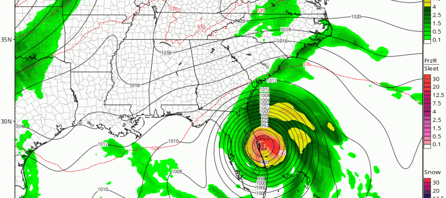
Hurricane Matthew Florida Landfall Tonight Latest Radars
HURRICANE MATTHEW ABOUT TO MAKE LANDFALL


Hurricane Matthew continues to move northwestward. The eye is clearly visible on the Melbourne Radar and the western edge of the eyewall is now about to touch the coast. Landfall should occur during the early morning hours however Hurricane Matthew will take a path along or just inland of the coast. The eye or at least part of the eye of the hurricane will remain partially over water for much of the trip up the coast toward Jacksonville. If it does this then any weakening will be be very slow to occur. Hurricane force winds will occur throughout the track up the Florida East Coast.
BULLETIN
HURRICANE MATTHEW ADVISORY NUMBER  36
NWS NATIONAL HURRICANE CENTER MIAMI FL       AL142016
1100 PM EDT THU OCT 06 2016

...EYE OF EXTREMELY DANGEROUS HURRICANE MATTHEW MOVING AWAY FROM
THE BAHAMAS AND TOWARD THE EAST COAST OF FLORIDA...


SUMMARY OF 1100 PM EDT...0300 UTC...INFORMATION
-----------------------------------------------
LOCATION...27.1N 79.2W
ABOUT 50 MI...80 KM NNW OF FREEPORT GRAND BAHAMA ISLAND
ABOUT 125 MI...200 KM SE OF CAPE CANAVERAL FLORIDA
MAXIMUM SUSTAINED WINDS...130 MPH...215 KM/H
PRESENT MOVEMENT...NW OR 325 DEGREES AT 13 MPH...20 KM/H
MINIMUM CENTRAL PRESSURE...939 MB...27.73 INCHES


WATCHES AND WARNINGS
--------------------
CHANGES WITH THIS ADVISORY:

The Tropical Storm Warning has been discontinued for Florida Bay
and the Florida Keys.

SUMMARY OF WATCHES AND WARNINGS IN EFFECT:

A Hurricane Warning is in effect for...
* Northwestern Bahamas, including the Abacos, Andros Island, Berry
Islands, Bimini, Eleuthera, Grand Bahama Island, and New Providence
* Boca Raton to South Santee River
* Lake Okeechobee

A Tropical Storm Warning is in effect for...
* Ocean Reef to south of Boca Raton
* Anclote River to Suwannee River
* North of South Santee River to Surf City

A Tropical Storm Watch is in effect for...
* Englewood to Anclote River

Interests elsewhere in the Florida Peninsula and in the Carolinas
should monitor the progress of Matthew.

A Hurricane Warning means that hurricane conditions are expected
somewhere within the warning area.  A warning is typically issued
36 hours before the anticipated first occurrence of tropical-storm-
force winds, conditions that make outside preparations difficult or
dangerous.  Preparations to protect life and property should be
rushed to completion.

A Tropical Storm Warning means that tropical storm conditions are
expected somewhere within the warning area within 36 hours.

For storm information specific to your area in the United
States, including possible inland watches and warnings, please
monitor products issued by your local National Weather Service
forecast office. For storm information specific to your area outside
the United States, please monitor products issued by your national
meteorological service.


DISCUSSION AND 48-HOUR OUTLOOK
------------------------------
At 1100 PM EDT (0300 UTC), the eye of Hurricane Matthew was
located by NOAA Doppler weather radars and an Air Force Reserve
reconnaissance aircraft near latitude 27.1 North, longitude 79.2
West. Matthew is moving toward the northwest near 13 mph (20 km/h).
A turn toward the north-northwest is expected on Friday, and a turn
toward the north expected Friday night or Saturday.  On the forecast
track, the center of Matthew will be moving near or over the east
coast of the Florida peninsula through Friday night, and near or
over the coasts of Georgia and South Carolina on Saturday.

Maximum sustained winds are near 130 mph (215 km/h) with higher
gusts.  Matthew is a category 4 hurricane on the Saffir-Simpson
Hurricane Wind Scale.  A gradual weakening is forecast during the
next 48 hours.  However, Matthew is expected to be a category 3 or
stronger hurricane as it moves near the coast of Florida.

Hurricane-force winds extend outward up to 60 miles (95 km) from the
center and tropical-storm-force winds extend outward up to 185 miles
(295 km).

The latest minimum central pressure reported by the reconnaissance
aircraft was 939 mb (27.73 inches). An automated station on the west
end of Grand Bahama Island recently reported a pressure of 943.1 mb
(27.85 inches).


HAZARDS AFFECTING LAND
----------------------
WIND:  Hurricane conditions should diminish over portions of the
northwestern Bahamas tonight.

Hurricane conditions are expected to first reach the hurricane
warning area in Florida during the next several hours and will
spread northward within the warning area through Friday.  Tropical
storm conditions will continue to spread northward in the warning
area along the Florida east coast tonight and Friday.

Hurricane conditions are expected to spread northward in the warning
area in Georgia and South Carolina Friday night and Saturday with
tropical storm conditions expected on Friday.

Winds increase rapidly in elevation in a tropical cyclone.
Residents in high-rise buildings should be aware that the winds at
the top of a 30-story building will be, on average, about one
Saffir-Simpson category higher than the winds near the surface.

Tropical storm conditions are expected in the tropical storm warning
area in the Carolinas on Friday night and Saturday.

STORM SURGE:  The combination of a dangerous storm surge and large
and destructive waves could raise water levels by as much as the
following amounts above normal tide levels...

Northwestern Bahamas...10 to 15 feet

The water could reach the following heights above ground if the peak
surge occurs at the time of high tide...

Sebastian Inlet, Florida, to Edisto Beach, South Carolina, including
portions of the St. Johns River...7 to 11 ft
Edisto Beach to South Santee River, South Carolina...4 to 6 ft
Boca Raton to Sebastian Inlet, Florida...4 to 6 ft
South Santee River, South Carolina, to Cape Fear, North Carolina...2
to 4 ft
Virginia Key to Boca Raton, Florida...1 to 3 ft

Surge-related flooding depends on the relative timing of the surge
and the tidal cycle, and can vary greatly over short distances.
Large waves generated by Matthew will cause water rises to occur
well in advance of and well away from the track of the center.

The combination of a dangerous storm surge and the tide will cause
normally dry areas near the coast to be flooded by rising waters
moving inland from the shoreline.  There is a danger of life-
threatening inundation during the next 36 hours along the Florida
east coast, the Georgia coast, and the South Carolina coast from
Boca Raton, Florida, to South Santee River, South Carolina.
There is the possibility of life-threatening inundation during the
next 48 hours from north of South Santee River, South Carolina, to
Cape Fear, North Carolina. For a depiction of areas at risk, please
see the Prototype National Weather Service Storm Surge Watch/Warning
Graphic. For information specific to your area, please see products
issued by your local National Weather Service forecast office.

The Prototype Storm Surge Watch/Warning Graphic is a depiction of
areas that would qualify for inclusion under a storm surge watch or
warning currently under development by the National Weather Service
and planned for operational use in 2017.  The Prototype Graphic is
available at hurricanes.gov.

RAINFALL:  Matthew is expected to produce total rainfall amounts in
the following areas:

The northern Bahamas...8 to 12 inches, isolated 15 inches
The Atlantic coast of the United States from Central Florida to
eastern North Carolina...6 to 12 inches with isolated totals near
15 inches along the coasts

TORNADOES:  An isolated tornado or two is possible along the
east-central Florida coast tonight.

SURF:  Swells generated by Matthew will continue to affect portions
of the north coast of Cuba and the Bahamas during the next few days,
and will spread northward along the east coast of Florida and the
southeast U.S. coast through the weekend.  These swells will likely
cause life-threatening surf and rip current conditions.  Please
consult products from your local weather office.


NEXT ADVISORY
-------------
Next intermediate advisory at 200 AM EDT.
Next complete advisory at 500 AM EDT.
Tropical cyclone updates at 1200 AM, 100 AM, 300 AM, and 400 AM EDT.

$$
Forecaster Beven
 Hurricane Matthew GFS Model

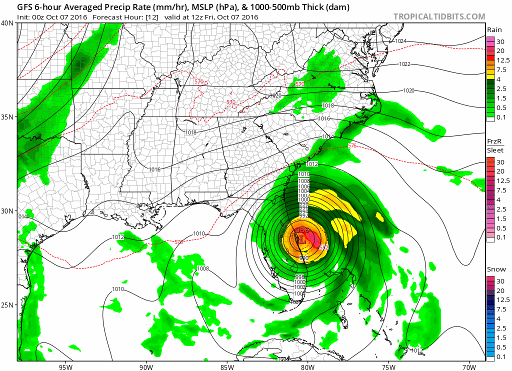
The GFS model run keeps the hurricane track just offshore bouncing off the coast. It also trended further north which increases the risk to coastal South Carolina as well as the south coast of North Carolina. Apparently the trough coming through the northeast is forecast to be a shade stronger. If this trend continues Hurricane Watches and Warnings will likely be extended northward.
WINTER 2016-2017 PART 3 NEW JERSEY
WINTER 2016-2017 PART 1 OCEAN WATER TEMPERATURES
WINTER 2016-2017 PART 2 ARCTIC SEA ICE AND SIBERIAN SNOW COVER
FiOS1 News Weather Forecast For Long Island
FiOS1 News Weather Forecast For New Jersey
FiOS1 News Weather Forecast For Hudson Valley
NATIONAL WEATHER SERVICE SNOW FORECASTS
LATEST JOESTRADAMUS ON THE LONG RANGE

Weather App

Don’t be without Meteorologist Joe Cioffi’s weather app. It is really a meteorologist app because you get my forecasts and my analysis and not some automated computer generated forecast based on the GFS model. This is why your app forecast changes every 6 hours. It is model driven with no human input at all. It gives you an icon, a temperature and no insight whatsoever.
It is a complete weather app to suit your forecast needs. All the weather information you need is right on your phone. Android or I-phone, use it to keep track of all the latest weather information and forecasts. This weather app is also free of advertising so you don’t have to worry about security issues with your device. An accurate forecast and no worries that your device is being compromised.
Use it in conjunction with my website and my facebook and twitter and you have complete weather coverage of all the latest weather and the long range outlook. The website has been redone and upgraded. Its easy to use and everything is archived so you can see how well Joe does or doesn’t do when it comes to forecasts and outlooks.
Just click on the google play button or the apple store button on the sidebar for my app which is on My Weather Concierge. Download the app for free. Subscribe to my forecasts on an ad free environment for just 99 cents a month.
Get my forecasts in the palm of your hand for less than the cost of a cup of Joe!
