HURRICANE JOSE NEARS TUESDAY SUMMERS LAST WEEKEND
HURRICANE JOSE NEARS TUESDAY SUMMERS LAST WEEKEND
The summer is down to its final weekend and we are going to see warm and somewhat humid conditions for both days and the odd chance for a downpour. Other than that this should be rainfree with a fair amount of sunshine once any morning low clouds burn off. We are at the point where daylight and darkness meet so the long nights this time of year tend to produce morning low clouds and even some patchy fog. Temperatures will be in the upper 70s to lower 80s for highs and nights will continue to bottom in the 60s. Satellite loop this morning shows Hurricane Jose sitting southeast of the North Carolina coast and moving northwestward at 9 mph with 80 mph winds. Jose is no threat to our area through Monday.
SATELLITE LOOP

REGIONAL RADAR

Radars are starting the day quiet. Later today a few pop up showers should appear but they should be widely scattered in nature and the vast majority of you won’t see any.
HURRICANE JOSE AND ITS IMPACT ON TUESDAY
NEW JERSEY
Weather models all seem to agree that there will be no direct hit from Hurricane Jose however there will be some impacts for the immediate coast. The back edge of the rain will make it close to the New Jersey coast . The area of gales will touch the Jersey shore however if you are west of the Garden State Parkway from Monmouth County southward you won’t even know its there. With winds going north and northwest there should not be a major coastal flooding event.
EASTERN PENNSYLVANIA, HUDSON VALLEY AND CONNECTICUT NORTH OF I-95
Hurricane Jose will pass well south and east of you and there will be no meaningful impacts.
COASTAL CONNECTICUT SOUTH OF RT 95 & LONG ISLAND NORTH SHORE
Jose will come close enought to put this area into fringe gales and there will be some impacts of coastal flooding at high tides. Some rain will graze the area as well but there should not be anything that creates major issues. Coastal flooding is a concern for the high tides Monday night into Tuesday with the wind initially from the east and northeast and then going north and northwest Tuesday night.
LONG ISLAND SOUTH SHORE
Gales will make it into the coastal areas on Tuesday and winds will increase and last longer as you go eastward. There will be some rain Tuesday into Tuesday night. Winds could gust into the 40 mph+ rainge for a brief time. However if Jose turns to the northeast as forecast, this will be manageable. Coastal flooding is a concern for the high tides Monday night and especially during the day Tuesday.
LONG ISLAND RIVERHEAD TO THE EAST END, SOUTHEASTERN CONNECTICUT
This area will see greater impacts with gale force winds especially right along the coast and out toward Greenport & Montauk. Winds will probably gust into the 40-50 mph range at times Tuesday into Tuesday night. The center of Jose however will pass far enough south for this area to stay out of the core of the circulation. Rough ocean seas will be building into Tuesday night as Jose makes its closest pass. Rain will move in Tuesday and last into Tuesday night before ending before daybreak Wednesday.
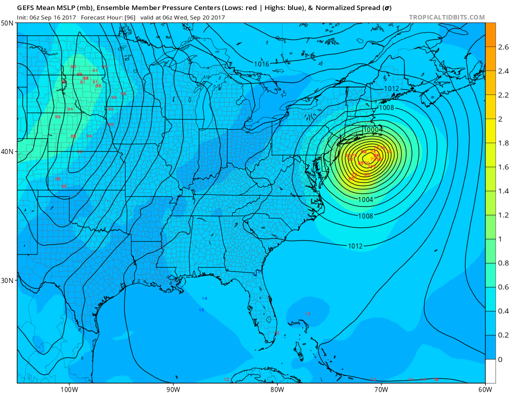
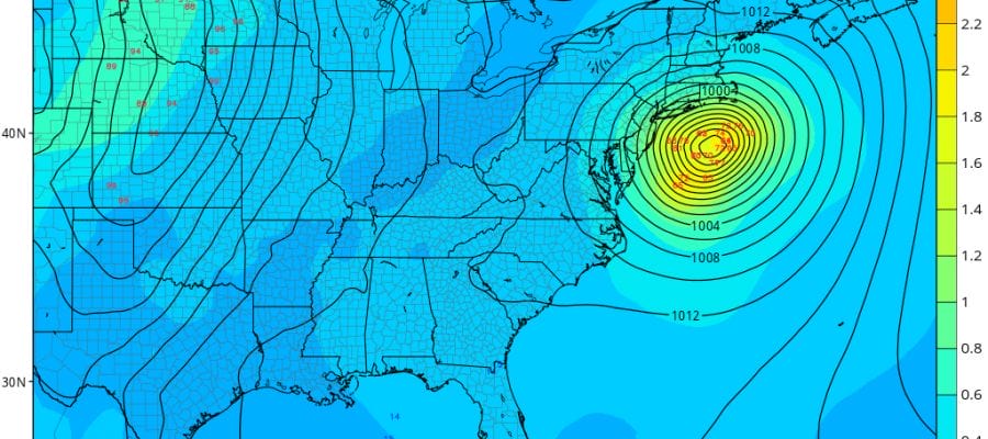
The map above shows the GFS models and various other GFS member models and virtually all of them have an offshore position. This shows us Hurricane Jose at its closest position to Long Island at 1am Wednesday. As long as the track remains offshore, the impacts will confined mostly to coastal areas as described earlier. Rainfall here should not be a problem except in areas to the east like Eastern Long Island and Southeastern Connecticut where you will be closer to the track and an inch or 2 of rain is possible. Areas to the west will see nothing that really matters.
 GET JOE A CIGAR IF YOU LIKE

FiOS1 News Weather Forecast For Long Island
FiOS1 News Weather Forecast For New Jersey
FiOS1 News Weather Forecast For Hudson Valley


