
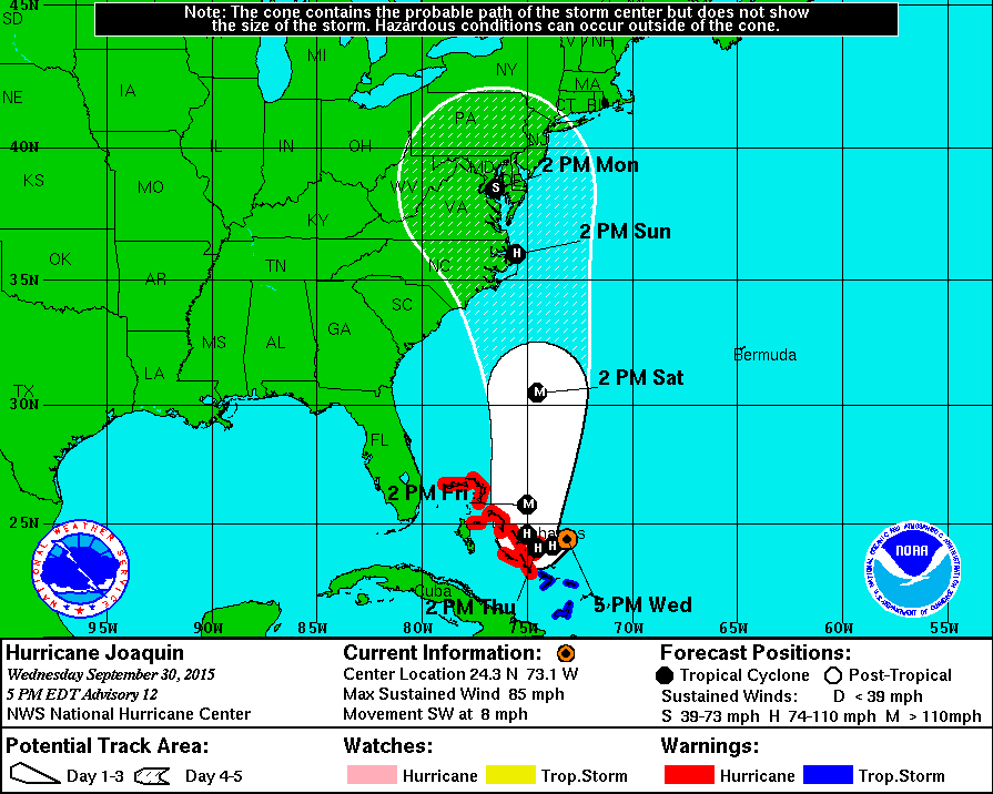
Satellite loops show Hurricane Joaquin is a very well defined and well formed hurricane and everything points to continued strengthening. It has been on a steady southwest course at about 8 mph and top wnids are at 85 mph this evening. This hurricane has a shot to become a category 3 hurricane before it makes landfall. Where it makes landfall we still aren’t sure.

..JOAQUIN MOVING SOUTHWESTWARD TOWARD THE CENTRAL BAHAMAS...


SUMMARY OF 500 PM EDT...2100 UTC...INFORMATION
----------------------------------------------
LOCATION...24.3N 73.1W
ABOUT 175 MI...285 KM ENE OF THE CENTRAL BAHAMAS
MAXIMUM SUSTAINED WINDS...85 MPH...140 KM/H
PRESENT MOVEMENT...SW OR 225 DEGREES AT 8 MPH...13 KM/H
MINIMUM CENTRAL PRESSURE...967 MB...28.56 INCHES


WATCHES AND WARNINGS
--------------------
CHANGES WITH THIS ADVISORY:

The Government of the Bahamas has issued a Hurricane Warning for
the Northwestern Bahamas including the Abacos, Berry Islands,
Eleuthera, Grand Bahama Island, and New Providence, but excluding
Andros Island and Bimini.

The Government of the Bahamas has issued a Tropical Storm Warning
for the Southeastern Bahamas, including the Acklins, Crooked Island,
Long Cay, the Inaguas, Mayaguana, and the Ragged Islands, but
excluding the Turks and Caicos Islands.

SUMMARY OF WATCHES AND WARNINGS IN EFFECT:

A Hurricane Warning is in effect for...
* Central Bahamas including Cat Island, the Exumas, Long Island,
Rum Cay, and San Salvador
* Northwestern Bahamas including the Abacos, Berry Islands,
Eleuthera, Grand Bahama Island, and New Providence, but excluding
Andros Island and Bimini

A Hurricane Watch is in effect for...
* Bimini

A Tropical Storm Warning is in effect for...
* Southeastern Bahamas including the Acklins, Crooked Island,
Long Cay, the Inaguas, Mayaguana, and the Ragged Islands, but
excluding the Turks and Caicos Islands.


KEY MESSAGES FROM THE NATIONAL HURRICANE CENTER FORECAST DISCUSSION
areas in the Bahamas should be rushed to completion.
2. A significant adjustment to the forecast has been made this
afternoon, and this shows an increased threat to the mid-Atlantic
states and the Carolinas. However, confidence in the details of the
forecast after 72 hours remains low, since we have one normally
excellent model that keeps Joaquin far away from the United States
east coast. The range of possible outcomes is still large, and
includes the possibility of a major hurricane landfall in the
Carolinas.
3. Every effort is being made to provide the forecast models with
as much data as possible. The NOAA G-IV jet has begun a series of
missions in the storm environment, and the National Weather Service
is launching extra balloon soundings.
4. Because landfall, if it occurs, is still more than three days
away, it is too early to talk about specific wind, rain, or surge
impacts from Joaquin in the United States. Even if Joaquin stays
well out to sea, strong onshore winds will create minor to moderate
coastal flooding along the coasts of the mid-Atlantic and
northeastern states through the weekend.
5. A hurricane watch for a portion of the U.S. coast could be
required as early as Thursday evening.
6. Many areas of the eastern U.S. are currently experiencing heavy
rains and gusty winds associated with a frontal system. This
inclement weather is expected to continue over the next few days,
which could complicate preparations for Joaquin should it head
toward the coast, and greatly exacerbate the impacts from the
hurricane. Heavy rains are likely to continue over these areas
even if the center of Joaquin stays out to sea.
toward the coast.
We will have more on this as the day progress and also please read my post regarding the global models and their handling of Joaquin. Also read my post on the afternoon models and the European which diverges from the others.
The Hurricane Center forecast track is to the right of the global GFS and Canadian Models and to the left of the European of last night. Needless to say if this is right and the track is to just east of Delaware Bay this would be a serious hurricane hit. We are still a long way away from the final outcome.
Be sure to download my weather app and subscribe to my forecasts. The app is free and the subscription is just 99 cents a month. The app is free of advertisement and there are no tracking or security issues.