Hurricane Irma 115 MPH Winds Heading West Labor Day Weekend
Hurricane Irma 115 MPH Winds
Heading West Labor Day Weekend No Threat To Land

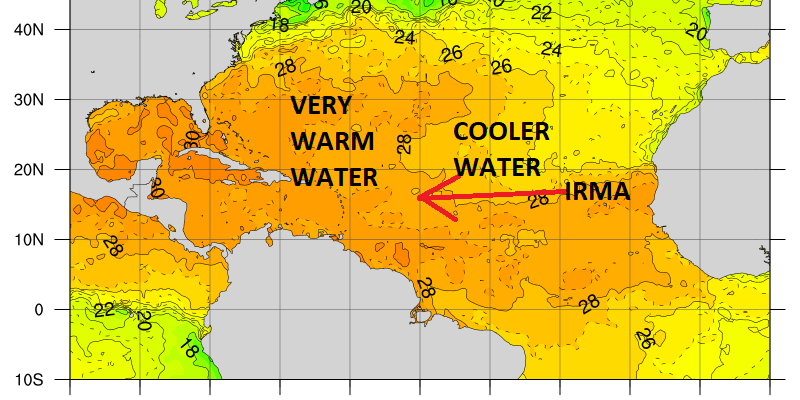
After the rapid strengthening that occurred yesterday it appears that Irma has leveled off for now. The satellite presentation this mornign is a bit on the ragged side but there is still an eye visible and the inner core of the hurricane remains well developed. One of the issues at the moment is that Irma is moving over a patch of relatively cool sea surface temperatures which is going to hold it back for another day or so.
HURRICANE IRMA SEA SURFACE TEMPERATURES

Once Hurricane Irma gets west of 45 degrees west it will begin to move over warmer waters (84 degrees or higher) which should set the stage for another round of rapid strengthening. It is from here that virutally all the global and hurricane intensity models take this to a category 4.

I’m still watching the upper low to the northwest of Hurricane Irma as this could be another factor that will hold back developement if the upper low does not get out of the way. This morning’s loop suggests the upper low is weakening some but it is still there. I don’t believe this should prevent Irma from doing what it is forecast to do which is respond to the building high pressure and turn to the west and then west southwest over the weekend.

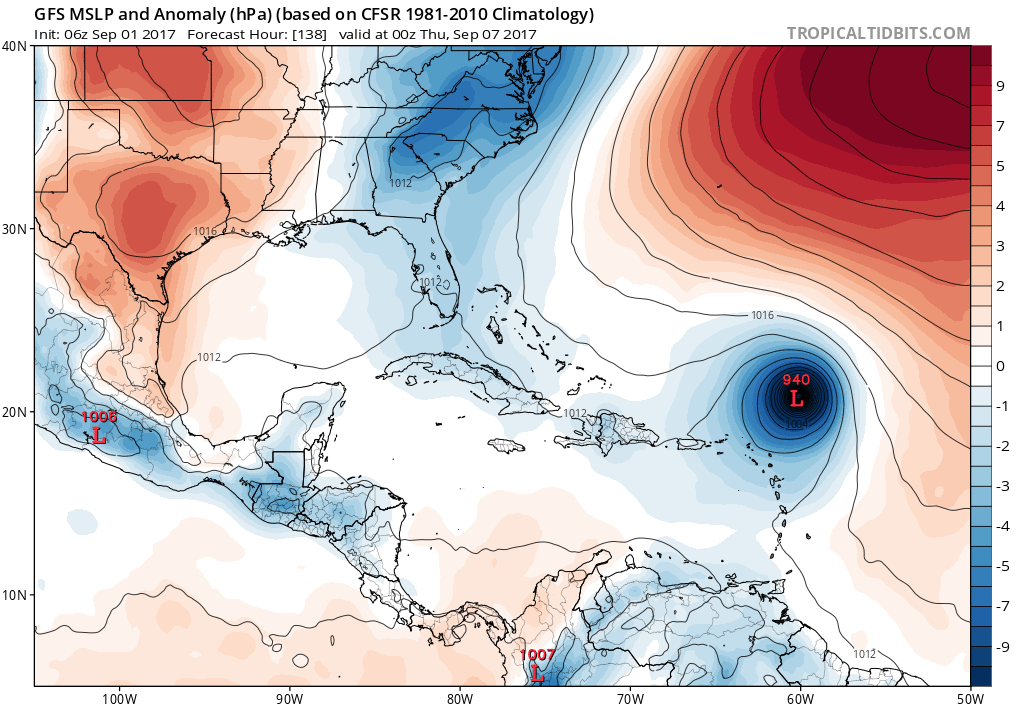
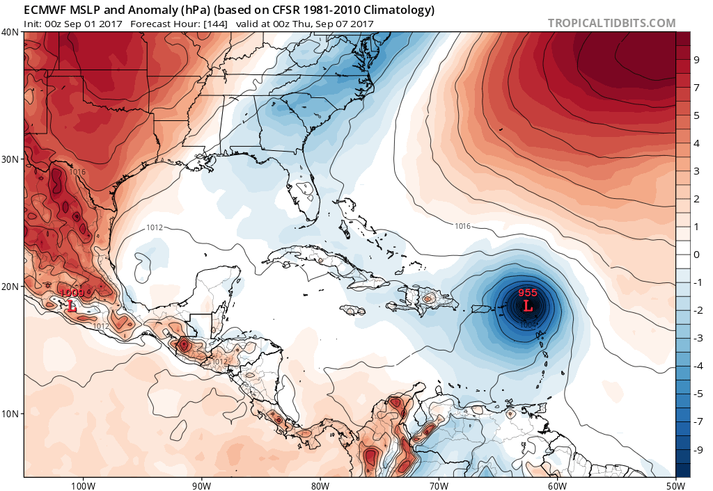
The questions of where Irma goes in the long term remain. The GFS overnight takes it well to the northeast of the Leewards while the European takes it right over the Leeward Islands.
HURRICANE IRMA GFS MODEL
HURRICANE IRMA EUROPEAN MODEL
The strength of the Atlantic ridge holds the key to all this. I think that Irma will wind up somewhere just to the East of the Bajamas later next week and then the question is will there be a mechanism to bring it up the east coast in some fashion. That answer is still many days away.
BULLETIN
Hurricane Irma Advisory Number 8
NWS National Hurricane Center Miami FL AL112017
500 AM AST Fri Sep 01 2017
…IRMA HOLDING STEADY WITH 115-MPH WINDS…
SUMMARY OF 500 AM AST…0900 UTC…INFORMATION
———————————————-
LOCATION…18.2N 36.5W
ABOUT 840 MI…1350 KM WNW OF THE CABO VERDE ISLANDS
ABOUT 1665 MI…2680 KM E OF THE LEEWARD ISLANDS
MAXIMUM SUSTAINED WINDS…115 MPH…185 KM/H
PRESENT MOVEMENT…WNW OR 300 DEGREES AT 12 MPH…19 KM/H
MINIMUM CENTRAL PRESSURE…967 MB…28.56 INCHES
WATCHES AND WARNINGS
——————–
There are no coastal watches or warnings in effect.
DISCUSSION AND 48-HOUR OUTLOOK
——————————
At 500 AM AST (0900 UTC), the center of Hurricane Irma was located
near latitude 18.2 North, longitude 36.5 West. Irma is moving
toward the west-northwest near 12 mph (19 km/h). A turn toward the
west is expected by tonight, followed by a turn toward the
west-southwest on Saturday.
Maximum sustained winds remain near 115 mph (185 km/h) with higher
gusts. Irma is a category 3 hurricane on the Saffir-Simpson
Hurricane Wind Scale. Fluctuations in strength, up or down, are
possible during the next few days, but Irma is expected to
remain a powerful hurricane through the weekend.
Hurricane-force winds extend outward up to 15 miles (30 km) from the
center, and tropical-storm-force winds extend outward up to 90 miles
(150 km).
The estimated minimum central pressure is 967 mb (28.56 inches).
HAZARDS AFFECTING LAND
———————-
None
NEXT ADVISORY
————-
Next complete advisory at 1100 AM AST.
MANY THANKS TO TROPICAL TIDBITS FOR THE WONDERFUL USE OF THE MAPS
 GET JOE A CIGAR IF YOU LIKE

Weather App

Don’t be without Meteorologist Joe Cioffi’s weather app. It is really a meteorologist app because you get my forecasts and my analysis and not some automated computer generated forecast based on the GFS model. This is why your app forecast changes every 6 hours. It is model driven with no human input at all. It gives you an icon, a temperature and no insight whatsoever.
It is a complete weather app to suit your forecast needs. All the weather information you need is right on your phone. Android or I-phone, use it to keep track of all the latest weather information and forecasts. This weather app is also free of advertising so you don’t have to worry about security issues with your device. An accurate forecast and no worries that your device is being compromised.
Use it in conjunction with my website and my facebook and twitter and you have complete weather coverage of all the latest weather and the long range outlook. The website has been redone and upgraded. Its easy to use and everything is archived so you can see how well Joe does or doesn’t do when it comes to forecasts and outlooks.
Just click on the google play button or the apple store button on the sidebar for my app which is on My Weather Concierge. Download the app for free. Subscribe to my forecasts on an ad free environment for just 99 cents a month.
Get my forecasts in the palm of your hand for less than the cost of a cup of Joe!