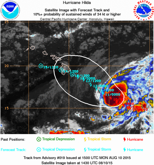
LOCATION...16.2N 149.8W
ABOUT 425 MI...680 KM SE OF HILO HAWAII
ABOUT 635 MI...1025 KM ESE OF HONOLULU HAWAII
MAXIMUM SUSTAINED WINDS...90 MPH...150 KM/H
PRESENT MOVEMENT...NW OR 305 DEGREES AT 9 MPH...15 KM/H
MINIMUM CENTRAL PRESSURE...979 MB...28.91 INCHES

NO TROPICAL STORM WATCHES ARE UP FOR HAWAII AT THIS TIME.

In the world of weather if you change one thing you change another. A weaker Hilda is responding more to the deep low level easterly flow while the high level westerlies are beginning to take their toll on the hurricane by shearing the tops off the thunderstorms creating hostile conditions for maintaining strength. The second development has been an overnight shift southward in the forecast track. If the weakening trend continues and the track is more westerly, then what is left of Hilda could very well track south of Hawaii as the latest forecast shows.

 The hurricane is small in size and looks less organized on the satellite picture above. The track drawn on the satellite pic is the old forecast which took the center over the big island of Hawaii probably as a depression or a weak tropical storm. The new track on the National Hurricane Center forecast takes it south of the big island.

Beyond 40 miles offshore hurricane warnings are posted but again no watches or warnings are up for the Hawaiian islands at this point. My guess is a watch of some kind could go up later today.

Meanwhile in the Atlantic Basin it remains dead quiet for the time being.