Hurricane Fiona Barrels Toward Nova Scotia
New Tropical Storm Forming Caribbean Autumn Has Arrived
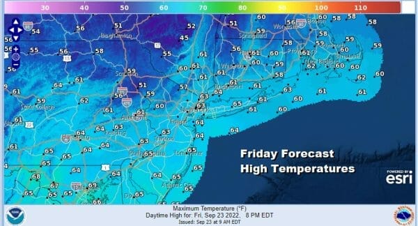
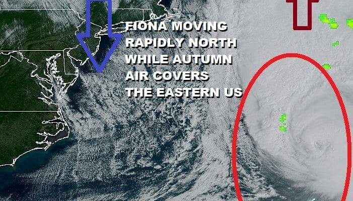
The first day of Autumn has arrived with real Autumn weather. We have seen the last many years where summer has basically extended itself into October but not this year. We have a day with lots of sunshine but a large high over the Great Lakes and Hurricane Fiona to the east are combining to make for a rather windy day. Temperatures this afternoon will top out in the very cool upper 50s and lower 60s.

Tonight will be a very cool night indeed with clear skies. It will still be rather breezy so overnight temperatures will be relatively uniform. Lows by Saturday morning will be in the 40s just about everywhere and some of the coolest spots will see lows down in the lower 40s.
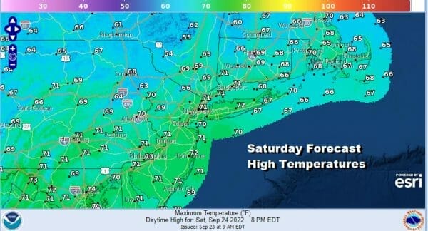
The cool high will move eastward and Hurricane Fiona will be heading toward Labrador so the pressure gradient will relax. Saturday will be the better of the two weekend days with lots of sunshine and less wind especially in the afternoon. Highs will reach the upper 60s and lower 70s.

Sunday sees the arrival of the next cold front so we will warm up ahead of it. Sunday morning should be dry but we will see an increasing chance for showers and thunderstorms Sunday afternoon into Sunday night. Highs Sunday will reach the mid to upper 70s in most places. The front marks the leading edge of another shot of very cool air that will build into the Eastern US for next week.
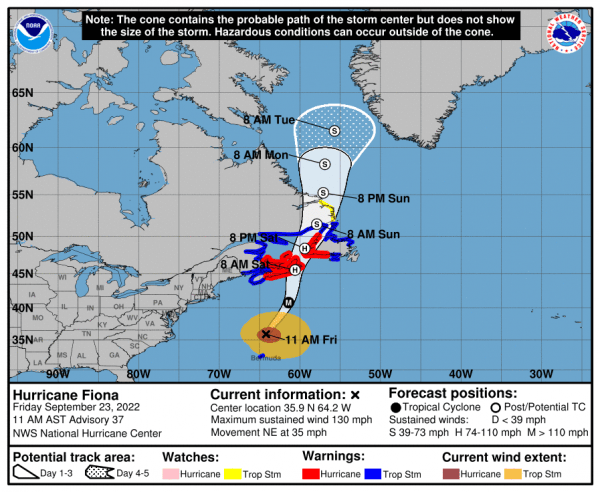
HURRICANE FIONA BARRELS TOWARD NOVA SCOTIA LANDFALL EARLY SATURDAY MORNING
Hurricane Warnings are up for the eastern half of Nova Scotia as well as western and southern Newfoundland. Tropical Storm Warnings up for the remainder of Nova Scotia and Newfoundland as well as New Brunswick back to the Maine coast. Hurricane Fiona is accelerating northward for a landfall early Saturday morning in Eastern Nova Scotia and then continuing northward passing west of Newfoundland into Labrador.
SUMMARY OF 1100 AM AST…1500 UTC…INFORMATION
LOCATION…35.9N 64.2W ABOUT 250 MI…405 KM N OF BERMUDA
ABOUT 600 MI S OF HALIFAX NOVA SCOTIA MAXIMUM SUSTAINED WINDS 130 MPH
PRESENT MOVEMENT…NE OR 45 DEGREES AT 35 MPH
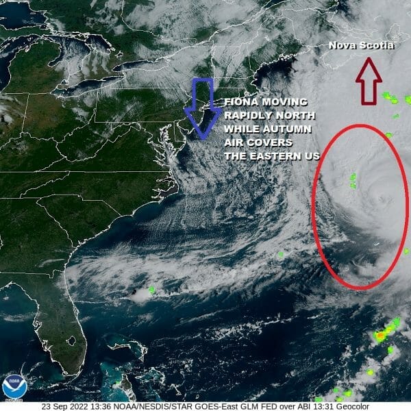
Fional is a category 4 hurricane with winds back to 130 mph. The fast forward motion at 35 mph is adding momentum to the wind on the east side of the center. Landfall in Eastern Nova Scotia will be early Saturday morning. The fast forward motion will slow the weakening process and Fiona will impact Atlantic Canada as a very powerful storm indeed. Gradually the storm will make the transformation into a cold core non tropical system which means the area of gale force winds (35 knots+) and storm force winds (50 knots +) will spread out and cover a large geographic area.
Tonight on the Joe & Joe Weather Show on youtube we will have complete coverage of Fiona as it heads for landfall in Nova Scotia with current weather conditions there and the outlook for overnight into Saturday for all of Atlantic Canada.
NEW TROPICAL DEPRESSION CENTRAL CARIBBEAN WILL BECOME A TROPICAL STORM
RISKS TO WESTERN FLORIDA ARE RISING FOR NEXT WEEK

Overnight a new tropical depression formed in the East Central Caribbean and it is moving west northwestward. The tropical depression is being sheared by northeast winds in the upper atmospehre. This is due to the outflow from Fiona well to the north. However that shear is forecast to disappear tonight and Satuday and the depression will begin to strengthen. There is a high probablity that this system will become a tropical storm by Saturday and a hurricane as early as later Sunday. The upper air flow over the Eastern US will create a weakness across the Eastern Gulf of Mexico and this system will likely turn more to north as it approaches the Northwest Caribbean. It will likely head into the Eastern Gulf of Mexico early next week and that will put the west coast of Florida at risk. We will also be covering this tonight on the Joe & Joe Weather Show on youtube. For now the depression is over the open waters of the Caribbean The forecast track takes it near Western Jamaica and that could put that island at risk for some very heavy rains Sunday.
BE SURE TO DOWNLOAD THE FREE METEOROLOGIST JOE CIOFFI WEATHER APP &
ANGRY BEN’S FREE WEATHER APP “THE ANGRY WEATHERMAN!
MANY THANKS TO TROPICAL TIDBITS & F5 WEATHER FOR THE USE OF MAPS
Please note that with regards to any severe weather, tropical storms, or hurricanes, should a storm be threatening, please consult your local National Weather Service office or your local government officials about what action you should be taking to protect life and property.


