Humidity Nudges A Little Lower Today Friday Very Warm Humid Weekend
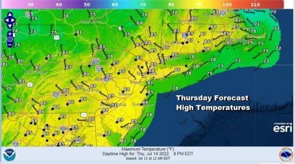
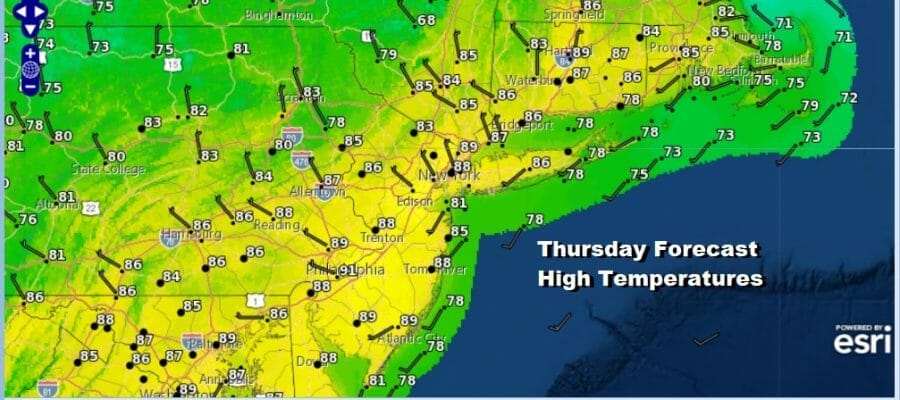
An upper trough will be moving through today. There isn’t much for this upper trough to work on but as it goes by and winds go west and northwest, we are going to see dew points edge lower and that will bring the humidity down somewhat and make things a little more comfortable. We will describe the day as a mix of sun and clouds. Highs will reach the upper 80s to around 90 degrees. I’m going to throw in the low chance for a scattered shower or thunderstorm but even if one develops, they will be few and far between. Other than some patchy clouds on the satellite there are no issues, and radars at least for now are quiet.
SATELLITE

WEATHER RADAR

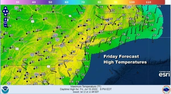
A slightly cooler and slightly drier air mass builds in for tonight and into the weekend. Skies should be clear tonight with lows in the 60s to lower 70s. Friday is the last day of the work week or getaway day and it should be a sunny rather comfortable day with highs in the 80s.
Saturday we will transition over to a very warm and humid air mass with a weak warm front going by. We will see some clouds Saturday morning and there could be a few showers or thunderstorms around midday. Then it turns very warm and humidity will start to rise. some sunshine should develop during the afternoon from west to east. Highs Saturday will be in th 80s.

We will do it again Sunday with sunshine very warm to hot and humid conditions. We will throw in the chance for a scattered shower or thunderstorm with the best chances inland. Highs will be in the mid 80s to near 90 degrees. Temperatures will be a little cooler along the shore.
Next week looks very warm to hot and on the humid side. The dry air masses that have been coming down out of Canada will be far less robust and not make it as far south as they have been. There are two weather fronts next week. The first will approach and move through Monday night so there could be some showers and thunderstorms late in the day Monday. Otherwise it will be very warm an humid with some sunshine. Highs will be in the mid 80s to near 90 degrees. Behind the front it will be just as hot for Tuesday and Wednesday. Highs will reach the upper 80s and lower 90s both days with high dew points. Another front arrives Thrursday with late showers or thundertorms and that might bring more significant relief to the humidity after it passes. As far as rainfall is concerned, there won’t be much to speak of. The lack of a widespread thunderstorm event means that most areas probably will see less than a half inch of rain over the next 7 days.
BE SURE TO DOWNLOAD THE FREE METEOROLOGIST JOE CIOFFI WEATHER APP &
ANGRY BEN’S FREE WEATHER APP “THE ANGRY WEATHERMAN!
MANY THANKS TO TROPICAL TIDBITS & F5 WEATHER FOR THE USE OF MAPS
Please note that with regards to any severe weather, tropical storms, or hurricanes, should a storm be threatening, please consult your local National Weather Service office or your local government officials about what action you should be taking to protect life and property.


