Humidity Holds But Temperatures Rise Today, Hot Monday Ahead of Cold Front

Humidity Holds But Temperatures Rise Today, Hot Monday Ahead of Cold Front

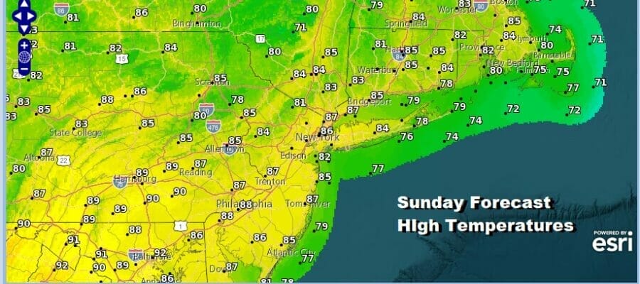
It is a Sunday of sunshine across much of the Northeast and Mid Atlantic states. After a nice cool start we are going to see temperatures warm up today. Highs this afternoon will reach the mid to upper 80s thanks to a west wind. However the humidity levels will remain reasonable today as there is not much in the way of tropical moisture around and the west wind is bringing air which has some increase in moisture but it is rather limited. Radar loops are in silent mode today with the exception of a few areas well north in Upstate NY and Northern New England.
SATELLITE WITH LIGHTNING STRIKES

WEATHER RADAR

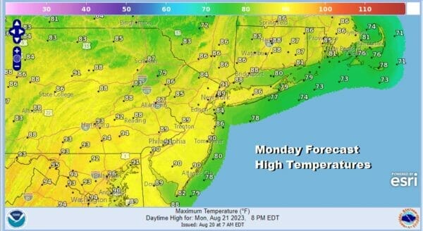
Tonight won’t be as cool with lows in the 60s to lower 70s in most places and that takes us to what will be a hot Monday. We will have sunshine, it will be a bit more humid but I would not call it oppressive. A west wind will take highs into the upper 80s and lower 90s in many locations and there won’t be much of a sea breeze if you are thinking a three day weekend at the shore.
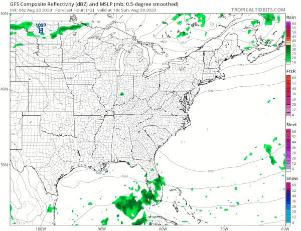
We do have a cold front that will be moving southeast from Eastern Canada and that front will pass through Monday night. The overall lack of mositure and a mostly stable atmosphere suggests that the front might produce a scattered shower or thunderstorm when it passes Monday night but they should be few and far between.
One thing we can say about the week ahead is that if you picked this as a vacation week, you picked well. The next chance of anything important regarding showers and thunderstorms won’t come until the very end of the week. Also after the cold front passes Monday night, high pressure builds into New England and keeps a mostly dry and cool onshore northeast flow across the Northeast into the Northern Mid Atlantic states.
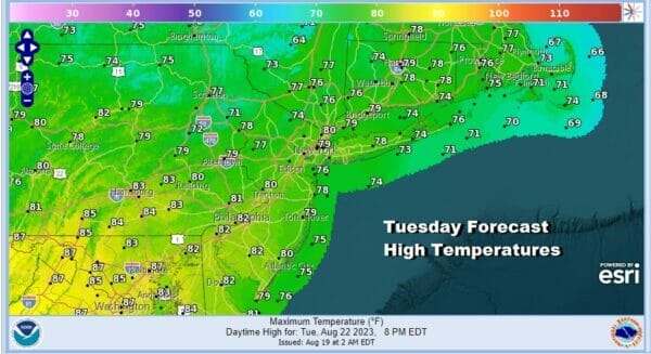
Basically Tuesday through Thursday is a wash rise repeat of sunshine each day and nothing more than perhaps a few passing clouds. Highs by day will be in the upper 70s to some lower 80s. Nights will be clear and cool with most lows in the mid 50s inland to lower 60s coast and warmer urban locations. The next chance for thunderstorms could come late Friday with another cold front.
BE SURE TO DOWNLOAD THE FREE METEOROLOGIST JOE CIOFFI WEATHER APP &
ANGRY BEN’S FREE WEATHER APP “THE ANGRY WEATHERMAN!
MANY THANKS TO TROPICAL TIDBITS FOR THE USE OF MAPS
Please note that with regards to any severe weather, tropical storms, or hurricanes, should a storm be threatening, please consult your local National Weather Service office or your local government officials about what action you should be taking to protect life and property.
(Amazon is an affilate of Meteorologist Joe Cioffi & earns commissions on sales.)


