
HRRR Model Snowfall Hurricane Force Gusts

HURRICANE FORCE GUSTS SUNDAY MORNING
If the HRRR model is to be believed, get ready for some strong winds especially if you are right on the coast. The HRRR model shows gusts to hurricane force tomorrow morning between 5am & 8am along the New Jersey shore near Sandy Hook and over the east end of Long Island near Montauk. This is in response to the developing storm just east of Montauk Sunday morning and an incredibly tight pressure gradient.
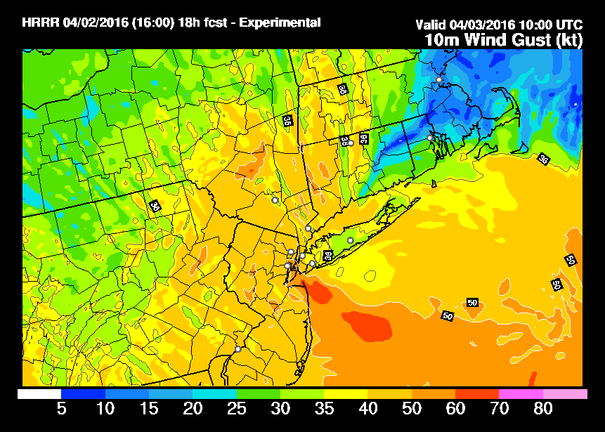
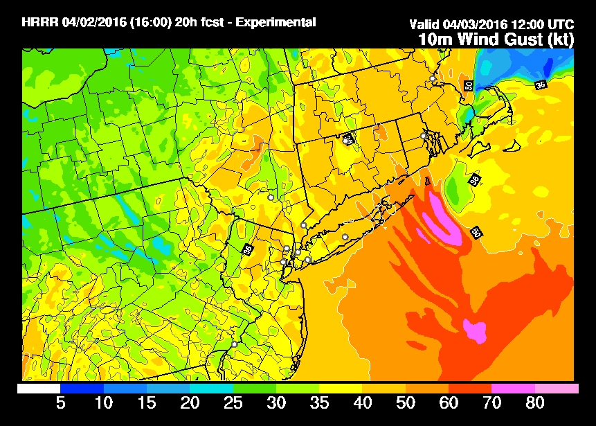
HRRR MODEL WIND FORECASTS 6AM 8AM
 Notice on the HRRR model at 8am gusts of 70 to 80 mph are indicated just offshore! Incredible if that happens as there will be wind gusts past hurricane force. There is a widespread area of 40 to 50 mph wind gusts covering the area tomorrow morning. So hang on for the ride!

Now with respect to snowfall the HRRR model is also showing areas of 1 to 2 inches of snow! Now picture if we get a burst of snow into that wind and you will wind up with blinding visibility for a short time Sunday morning. So if you are traveling during the early morning hours hang on to the steering wheel and travel with care.
The satellite loop shows the intense disturbance that will be responsible for this dropping southeastward from the Great Lakes and heading to the east coast. It is missing all the tropical moisture that moved through today which is good news because that prevents us from having one incredible storm Sunday morning.
SATELLITE LOOP


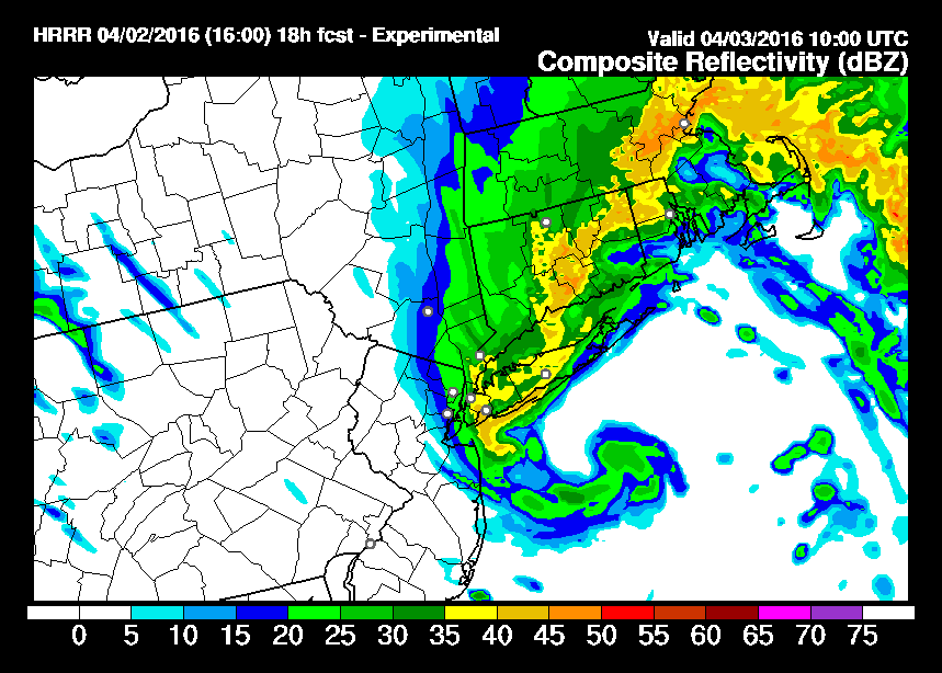
Radar is showing the first area of rain moving out but as the evening progresses keep an eye on the regional and local radars. Take a look at the HRRR model simulated radar at 6am Sunday. It actually puts Long Island, New York City, and parts of Connecticut under the “comma head” of the developing storm center. If this is correct, we could 2 to 3 hours of blinding snow and very strong winds.
HRRR MODEL SIMULATED RADAR
 LOCAL RADAR LOOPS


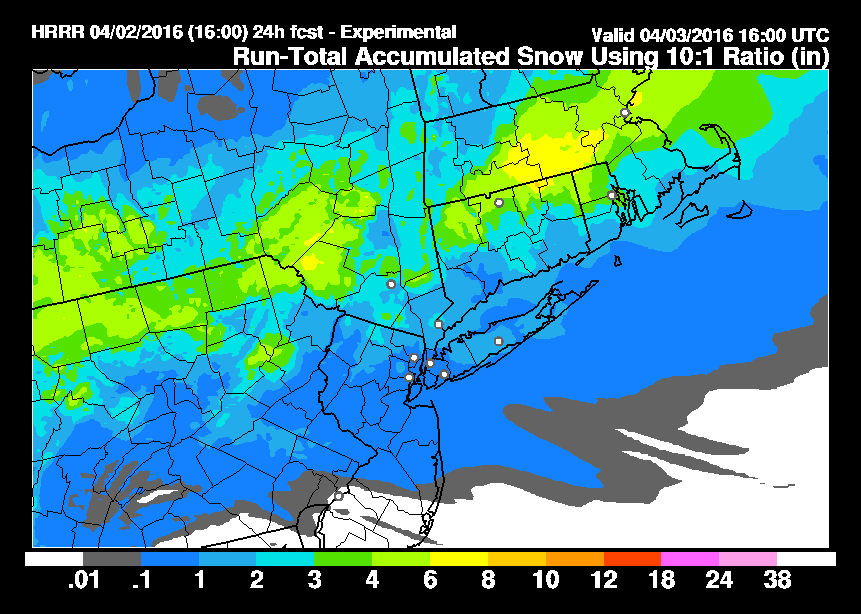
The HRRR model total snowfall map shows areas of 1 to 2 inches of snow for Long Island and parts of Southeastern New York, Northern New Jersey, and Connecticut.
HRRR MODEL TOTAL SNOWFALL FORECAST
 So look for deteriorating weather conditions tonight. Some thunderstorms could occur in all this after midnight as the development occurs and also when the comma head takes shape overnight. This is going to be a wild ride early Sunday morning.
FiOS1 News Weather Forecast For Long Island
FiOS1 News Weather Forecast For New Jersey
FiOS1 News Weather Forecast For Hudson Valley
NATIONAL WEATHER SERVICE SNOW FORECASTS
LATEST JOESTRADAMUS ON THE LONG RANGE
Weather App

Don’t be without Meteorologist Joe Cioffi’s weather app. It is really a meteorologist app because you get my forecasts and my analysis and not some automated computer generated forecast based on the GFS model. This is why your app forecast changes every 6 hours. It is model driven with no human input at all. It gives you an icon, a temperature and no insight whatsoever.
It is a complete weather app to suit your forecast needs. All the weather information you need is right on your phone. Android or I-phone, use it to keep track of all the latest weather information and forecasts. This weather app is also free of advertising so you don’t have to worry about security issues with your device. An accurate forecast and no worries that your device is being compromised.
Use it in conjunction with my website and my facebook and twitter and you have complete weather coverage of all the latest weather and the long range outlook. The website has been redone and upgraded. Its easy to use and everything is archived so you can see how well Joe does or doesn’t do when it comes to forecasts and outlooks.
Just click on the google play button or the apple store button on the sidebar for my app which is on My Weather Concierge. Download the app for free. Subscribe to my forecasts on an ad free environment for just 99 cents a month.
Get my forecasts in the palm of your hand for less than the cost of a cup of Joe!
![]()
![]()

MENTION JOE CIOFFI AND GET A 5% DISCOUNT


