Hot Humid Weather On The Way Severe Weather Risk
Showers Thunderstorms Start July 4th Weekend
Hot Humid Weather On The Way Severe Weather Risk
Showers Thunderstorms Start July 4th Weekend
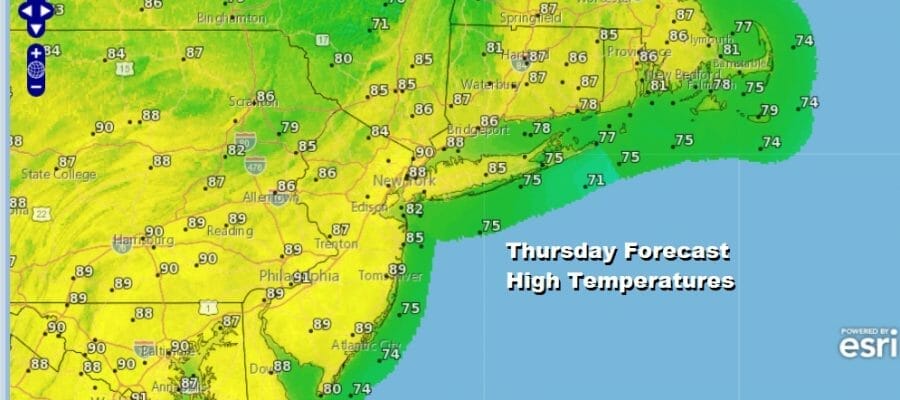
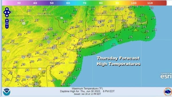
We have another day of sunny sunshine ahead but we will start to see temperatures move up High pressure is settled to our south and we have a mostly west wind today. This is not a wind direction where humidity levels rise quickly and while dew points will come up today to the upper 50s and lower 50s, I don’t think that is uncomfortable. High temperatures will reach the mid 80s to near 90 with cooling sea breezes right along the ocean shores. The atmosphere remains stable so no showers or thunderstorms are forecast today nor are they forecast for tomorrow.
SATELLITE

WEATHER RADAR

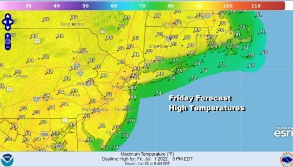
There are no issues tonight with clear skies and lows in the mid 60s to lower 70s. Friday will be the one day this week that I would describe as hot and yes it will definitely be humid and uncomfortable. We will have plenty of sunshine and highs will reach the low and even a few middle 90s with cooling sea breezes again at the beaches
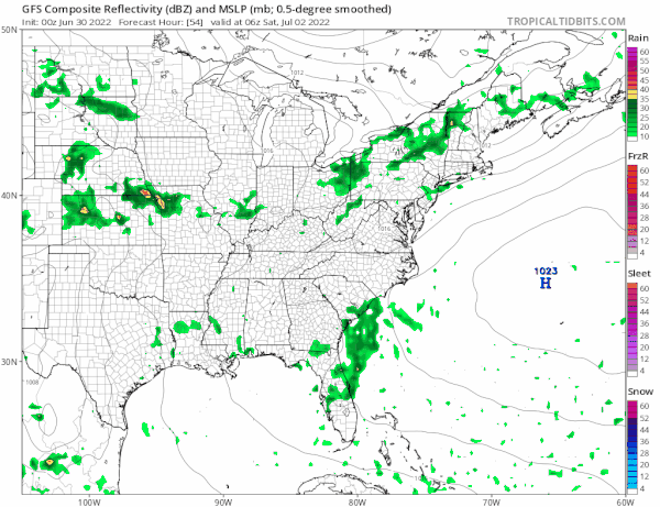
Now we move on to the July 4th weekend. Saturday we have a cold front that will be approaching and attempting to move through. Early Saturday morning a few scattered showers or even a thunderstorm will pass through as a weak trough goes by. This will just make it more humid for Saturday. Then it will be a matter of seeing how much daytime heating we get and what happens when the cold front nears later in the day.

The Storm Prediction Center has much of Eastern Pennsylvania to Southern New England under severe weather risk for Saturday. Sometimes early storms can tend to stabilize the atmosphere somewhat and lessen severe weather risk for later in the day. That may not necessarily be the case this time around if we get enough daytime heating in a steamy atmosphere. Some sun will likely develop and highs will be in the 80s.
The front will temporarily get hung up nearby so there might be some leftover showers early Sunday morning before weather conditions improve. Not all models show rain early Sunday morning and I have been leaning optimistic all week that we will see decreasing clouds and increasing sun for Sunday. Highs Sunday will be in the low to mid 80s. We are going to be optimistic for Monday with some sunshine and clouds. Highs will be in the 80s. Weather models are all over the place for Sunday and Monday as they can’t seem to figure out whether there will be a second cold front coming through Monday or does that wait for later Tuesday. For now we will leave our original ideas on the weekend basically in place.
BE SURE TO DOWNLOAD THE FREE METEOROLOGIST JOE CIOFFI WEATHER APP &
ANGRY BEN’S FREE WEATHER APP “THE ANGRY WEATHERMAN!
MANY THANKS TO TROPICAL TIDBITS FOR THE USE OF MAPS
Please note that with regards to any severe weather, tropical storms, or hurricanes, should a storm be threatening, please consult your local National Weather Service office or your local government officials about what action you should be taking to protect life and property.


