Hot Humid Tuesday Otherwise Warm Week Ahead
Hot Humid Tuesday Otherwise Warm Week Ahead
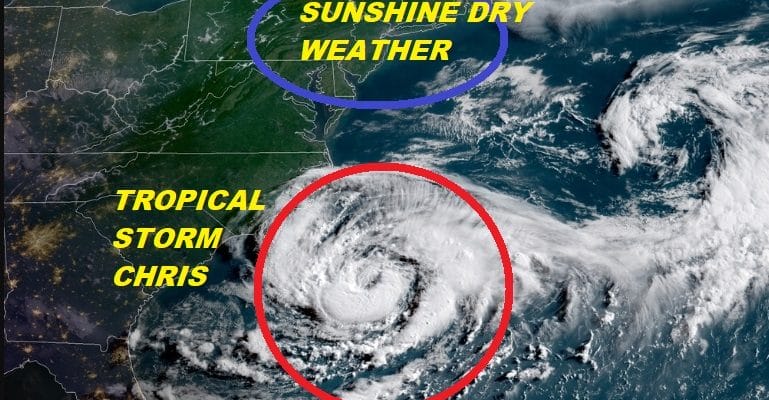
Tropical Storm Chris Remains Offshore Carolinas
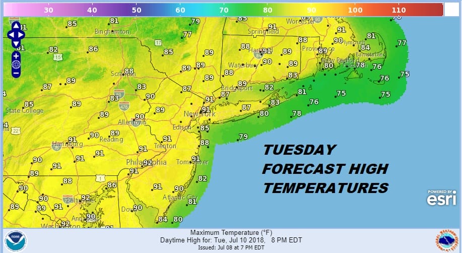
This stretch of great weather continues today as this will be another day of low humidity and sunshine with temperatures in the warm mid to upper 80s but the dew points today remain in the 50s. You can tell by the color of the sky this morning as it still remains that deep blue color that the humidity has not come back yet. This is has been quite a spectacular Canadian air mass that has come down and now we see a change to hot and more humid conditions on Tuesday with high temperatures in the upper 80s to some lower 90s. We are looking at sunshine Tuesday and just the chance for a thunderstorm as another cold front moves through. No widespread activity is forecast.
EASTERN SATELLITE

REGIONAL RADAR

After Tuesday we will see a slightly drier air mass for the rest of the week with very warm temperatures but not unreasonable and humidity levels won’t be too bad either Wednesday through Friday. Highs by day will be mostly in the mid to upper 80s and nights will be in the 60s to some lower 70s. It appears to be avery quiet week
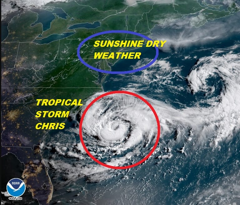
Overnight Tropical Storm Chris has held its own as it continues to sit off the North Carolina coast well offshore and with no impacts to land other than some coastal clouds and rough surf conditions over the Carolina shoreline. Chris is still forecast to become a hurricane sometime today or tonight and it is still forecast to move out to the northeast on Tuesday. Other than marine interests and wave action and rip currents at the beaches later this week there will be no impact. There could be a close call to the Canadian Maritime Provinces like Nova Scotia & New Foundland Thursday.
...CHRIS MEANDERING WELL OFF THE COAST OF THE CAROLINAS...
...EXPECTED TO STRENGTHEN TODAY...


SUMMARY OF 500 AM EDT...0900 UTC...INFORMATION
----------------------------------------------
LOCATION...32.4N 74.6W
ABOUT 200 MI...320 KM SSE OF CAPE HATTERAS NORTH CAROLINA
MAXIMUM SUSTAINED WINDS...60 MPH...95 KM/H
PRESENT MOVEMENT...S OR 180 DEGREES AT 1 MPH...2 KM/H
MINIMUM CENTRAL PRESSURE...999 MB...29.50 INCHES


WATCHES AND WARNINGS
--------------------
There are no coastal watches or warnings in effect.

Interests along the coast of North Carolina should monitor the
progress of this system.


DISCUSSION AND OUTLOOK
----------------------
At 500 AM EDT (0900 UTC), the center of Tropical Storm Chris was
located near latitude 32.4 North, longitude 74.6 West. Chris is
drifting toward the south near 1 mph (2 km/h).  The cyclone is
expected to remain nearly stationary during the next day or so.
A northeastward motion is forecast to begin late Tuesday, and Chris
is forecast to accelerate northeastward on Wednesday and Thursday.

Maximum sustained winds are near 60 mph (95 km/h) with higher gusts.
Strengthening is expected during the next couple of days, and Chris
is forecast to become a hurricane late today or tonight.

Tropical-storm-force winds extend outward up to 70 miles (110 km)
from the center.

The estimated minimum central pressure based on data from an Air
Force reconnaissance aircraft is 999 mb (29.50 inches).


HAZARDS AFFECTING LAND
----------------------
SURF:  Swells generated by Chris are expected to increase and affect
portions of the coasts of North Carolina and the mid-Atlantic states
during the next few days.  These swells could cause life-threatening
surf and rip current conditions.  Please consult products from your
local weather office.
 GET JOE A CIGAR IF YOU LIKE

LATEST JOESTRADAMUS ON THE LONG RANGE


