Hot Humid Today Severe Weather Risk Tuesday
Hot Humid Today Severe Weather Risk Tuesday
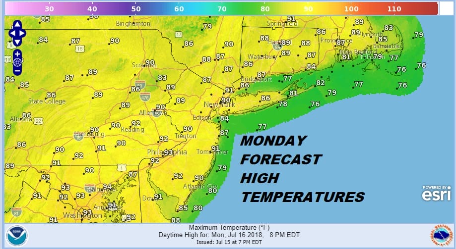
We begin the week with the one hot and humid day. We should have plenty of sunshine today with just some passing clouds. Afternoon highs will reach the lower 90s in most areas except along the coast. This is going to be the one hot and humid day this week as Tuesday we will see a cold front approach. It will be humid on Tuesday and there will be some thunderstorms developing during the afternoon and evening as the front sweeps through from west to east.
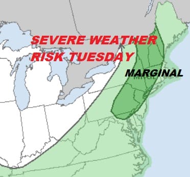
SEVERE WEATHER RISK TUESDAY

The Storm Prediction Center has increased the geographic coverage area of the marginal risk for severe weather. This means there will be some isolated severe thunderstorms possible embedded in a larger area of downpours and thunderstorms that move through. It seems that everyone should see something out of this. Temperatures on Tuesday will be in the 80s.
EASTERN SATELLITE

REGIONAL RADAR

Radars are quiet this morning but we could see some pop up thunderstorms developing late this afternoon and evening but they will be just that and scattered in nature.
Once the front passes Wednesday and Thursday will be warm but dry with low humidity and sunshine. Highs will be in the 80s. As we head into next weekend it appears that the humidity will be coming back but a wetter pattern could develop through next weekend and into next week as a slow moving cold front inches toward the East Coast. We will discuss this further later today in our long range post.
Please note that with regards to any tropical storms or hurricanes, should a storm be threatening, please consult your local National Weather Service office or your local government officials about what action you should be taking to protect life and property.
 GET JOE A CIGAR IF YOU LIKE

LATEST JOESTRADAMUS ON THE LONG RANGE


