
High Wind Warning Long Island Strong Winds Tonight Gusting 50 to 60 Mph
Heavy Downpours Much Colder Friday

High Wind Warning Long Island Strong Winds Tonight Gusting 50 to 0 Mph
Heavy Downpours Much Colder Friday
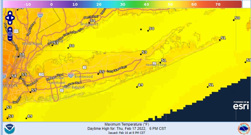
Many yearn for spring but Long Islanders know that spring is not a very nice time of year on Long Island thanks to the cold ocean which lags the spring warm up for the land mass to the west. Today will be one of those days where the south wind off the ocean will keep temperatures lower but the low ahead of the next cold front is so strong that highs will still make it into the low and mid 50s.

We don’t think there will be any rain Thursday other than the odd shower. That will wait until Thursday night. The dayside Thursday should be dry with changeable sky conditions. Clouds will take over completely during the afternoon and then the winds will really start to crank Thursday night. High wind warnings are in effect for Long Island for winds gusting 50 to 60 mph tonight.

Rain will likely arrive after 9pm and then winds will increase rapidly and start gusting to 40 to 50 mph at times especially along shore locations and over the East End. The strongest winds will be from 11pm until about 7am when the front passes. Temperatures will still be in the 50s Friday morning and then drop rapidly to the upper 30s by evening.
 Rain will end around 8am and then look for decreasing clouds as the day wears on with a gusty northwest wind. Skies will clear Friday night with lows in the lower 20s. Saturday will be a cold day with some early sun but look for clouds coming in around midday. A cold front and upper trough could trigger a few scattered snow showers in the afternoon as the next front passes.
Sunday will be a nice day of sunshine to finish off the weekend. Highs will be in the upper 30s and lower 40s. Monday will be dry before the next storm system heads our way with some rain arriving during Tuesday and lasting into Wednesday morning.
SATELLITE

WEATHER RADAR

BE SURE TO DOWNLOAD THE FREE METEOROLOGIST JOE CIOFFI WEATHER APP &
ANGRY BEN’S FREE WEATHER APP “THE ANGRY WEATHERMAN!
MANY THANKS TO TROPICAL TIDBITS & F5 WEATHER FOR THE USE OF MAPS
Please note that with regards to any severe weather, tropical storms, or hurricanes, should a storm be threatening, please consult your local National Weather Service office or your local government officials about what action you should be taking to protect life and property.