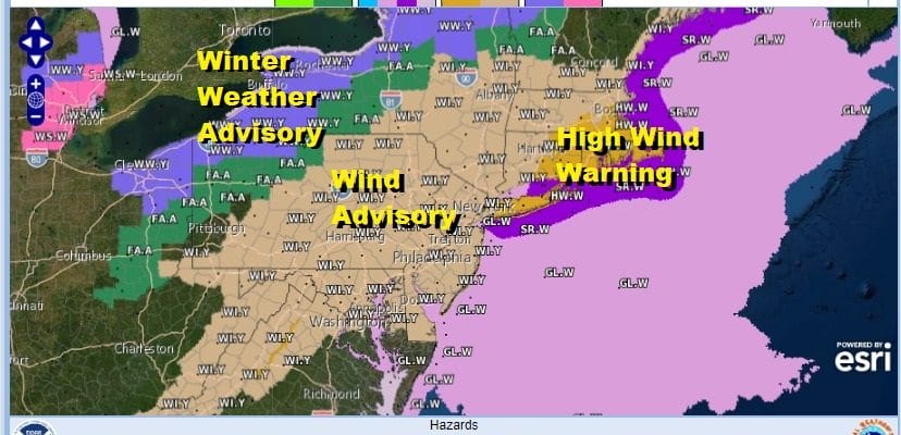
High Wind Warning & Wind Advisories
Strong Gusty Winds Tonight Some Heavy Downpours Colder Dry Weekend

Strong Gusty Winds Tonight Some Heavy Downpours Colder Dry Weekend
HIGH WIND WARNINGS & WIND ADVISORIES ARE POSTED
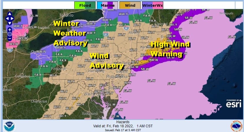
High Wind Warnings are posted for coastal areas from Long Island, Southeast Connecticut eastward to Southeastern New England including Rhode Island and Cape Cod. Winds in the warning area will gust 50 to 60 mph at times overnight. Wind Advisories are posted for inland areas extending north into Central New England and south into Northwestern Virginia. Inland gusts late today and tonight will exceed 40 mph at times.
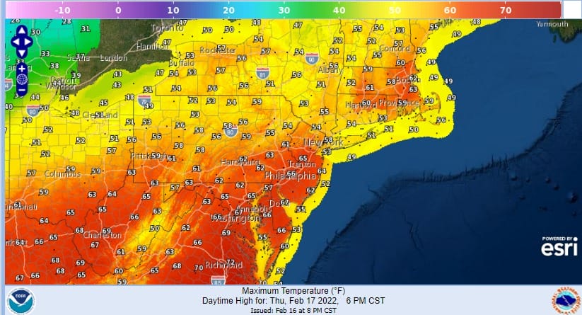
The highlight for today will be temperatures that will reach up into the 60s in many locations thanks to a strong cold front that is moving east. The highlight for tonight however will be the strong gusty winds and some heady downpours as the cold front arrives and passes offshore Friday morning. However we don’t expect any rain today other than maybe the odd shower that could pop up in the south southwest flow.
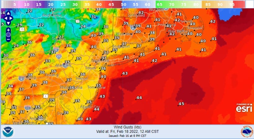
While it will be breezy during Thursday the winds will be picking up considerably Thursday night. Winds will gust to 30 to 40 mph inland with the strongest winds this afternoon into tonight, and 40 to 50 mph or higher along the coast with the peak winds coming between 10pm and 6am Friday. The strongest wind gusts will be in Southeastern New England where winds will gust to 50 to 60 mph at times during the early morning hours.

While we will see some rain with heavy downpours overnight, rainfall amounts should be generally under 1 inch. While the snowmelt will mean the ground will be saturated before the rain comes, the rainfall amounts will likely be just low enough to prevent flash flooding. Clouds will be increasing as the day wears on and expect the rain to arrive from west to east during the evening hours and then it should be mostly done by daybreak except in Eastern Connecticut and Long Island eastward. Wind gusts on the map above are from midnight and 4am respectively.
SATELLITE

WEATHER RADAR

Once the front passes winds shift to strong northwest and colder air comes back in for Friday. The highs for the day will be at midnight with readings in the upper 50s and lower 60s. Then during the day on Friday temperatures will settle into 40s by midday and into the mid 30s by late afternoon. Look for decreasing clouds as the day wears on. Skies will clear Friday night and Saturday morning lows will be in the upper teens to mid 20s.

The weekend brings dry cold air for Saturday and a secondary cold front will be moving through in conjunction with an upper trough so we will throw in the chance that there could be a snow shower and the outside chance for a heavier snow squall when the front passes. Saturday highs will be in the upper 30s and lower 40s. Dry air follows the front so Sunday looks good with sunshine. Lows Sunday morning will be in the upper teens and lower 20s. Sunday highs will reach the upper 30s and lower 40s. Monday looks dry and seasonal with sunshine. The next in this series of storm systems will be coming out of the southern plains and taking a similar track as Thursday’s system but it will not be as strong. Temperatures will warm up ahead of it so look for some rain arriving on Tuesday and lasting into the early part of Wednesday.
BE SURE TO DOWNLOAD THE FREE METEOROLOGIST JOE CIOFFI WEATHER APP &
ANGRY BEN’S FREE WEATHER APP “THE ANGRY WEATHERMAN!”
MANY THANKS TO TROPICAL TIDBITS FOR THE USE OF MAPS
Please note that with regards to any severe weather, tropical storms, or hurricanes, should a storm be threatening, please consult your local National Weather Service office or your local government officials about what action you should be taking to protect life and property.


