Heavy Rain Possibility For Friday
HEAVY THUNDERSTORMS LATE FRIDAY
MARGINAL RISK FOR SEVERE
HEAVY RAIN POSSIBILITY
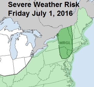
We earlier posted about the marginal risk for severe weather late Friday and Friday night as a cold front will be moving through. What I think makes this frontal approach a little different than the others is that there is going to be an injection of tropical moisture into the mix. That I think leads to the possibility that some of these thunderstorms could produce some locally heavy rains. So I’m taking a shot in my forecast and emphasizing that there could be some substantial rain in some places (1-2 inches) in some of these thunderstorms. Not everyone will participate but a larger area than average should see some of this.
Heavy Rain Possibility For Friday
Satellite Loop

Looking at the satellite loop across the Carolinas and Virginia southward there is a build up of tropical marine air in this area that will be lifted northward tonight and Friday. You will notice that humidity levels on Friday will be higher than we have seen in a while. This should juice up the atmosphere somewhat. We are also getting to the time of year where the marine influence begins to lessen somewhat in terms of being a thunderstorm killer. This could be a help to Long Island which is a thunderstorm graveyard through the spring. A sampling of water temperatures around the area show they have warmed to 70 or better at buoys just offshore.
STATION/POSITION TIME  SKY/WX   TEMP    WIND        PRES    VSBY  WAVE
                                AIR SEA DIR/SP/G                  HT/PER
                 (UTC)          (F)     (DEG/KT/KT) (MB)    (MI)  (FT/S)
NY HARB ENTRANCE 1650            72 72  210/  6/  8 1016.7          2/ 8
20S FIRE ISLAND  1650            71 71  270/  6/  6 1016.6          3/ 8
GREAT SOUTH BAY  1715            74 78  230/ 12/ 14   N/A
23 SSW MONTAUK P 1650            71 72  230/  4/  4 1016.7          3/ 8
15 E BARNEGAT LI 1722               74                N/A           3/ 8
HUDSON CANYON    1750            71 71              1016.8          3/ 7
KINGS POINT      1700            77 72              1016.2
EXECUTION ROCKS  NOT AVBL
CENTRAL LI SOUND 1700            72     230/  8/ 10   N/A           1
EASTERN LI SOUND 1700            68 63  240/  8/ 12   N/A
ROBBINS REEF     1700            75     160/ 11/ 12 1015.8
$$

Nothing is showing up on the regional radar at the moment but as we go through the night we should start to see some activity pop up. We will keep a close eye on this.
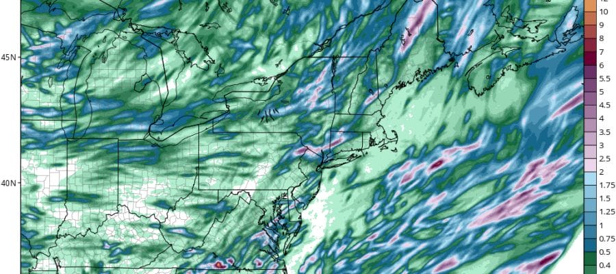
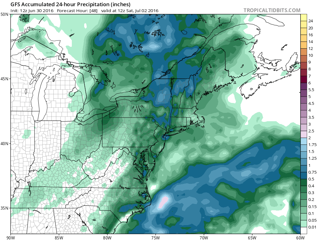
Heavy Rain Possibility For Friday GFS Rainfall Forecast
Heavy Rain Possibility For Friday NAM Rainfall Forecast

Models of course have their own idea. The NAM model did well with the thunderstorms the other day and it stripes a 2 to 3 inch rainfall zone in the Hudson Valley and Northwest Connecticut. The Gfs model has a slightly different picture of all this. Models are going to change and in situations like this the only thing a forecaster can do is point out the possibility and then let the rain fall or the chips fall where they may. Either way the 4th of July holiday weekend continues to look very good with sunshine and low humidity right into Monday.
JOESTRADAMUS HURRICANE SEASON GUEST FORECAST
FiOS1 News Weather Forecast For Long Island
FiOS1 News Weather Forecast For New Jersey
FiOS1 News Weather Forecast For Hudson Valley
NATIONAL WEATHER SERVICE SNOW FORECASTS
LATEST JOESTRADAMUS ON THE LONG RANGE
Weather App

Don’t be without Meteorologist Joe Cioffi’s weather app. It is really a meteorologist app because you get my forecasts and my analysis and not some automated computer generated forecast based on the GFS model. This is why your app forecast changes every 6 hours. It is model driven with no human input at all. It gives you an icon, a temperature and no insight whatsoever.
It is a complete weather app to suit your forecast needs. All the weather information you need is right on your phone. Android or I-phone, use it to keep track of all the latest weather information and forecasts. This weather app is also free of advertising so you don’t have to worry about security issues with your device. An accurate forecast and no worries that your device is being compromised.
Use it in conjunction with my website and my facebook and twitter and you have complete weather coverage of all the latest weather and the long range outlook. The website has been redone and upgraded. Its easy to use and everything is archived so you can see how well Joe does or doesn’t do when it comes to forecasts and outlooks.
Just click on the google play button or the apple store button on the sidebar for my app which is on My Weather Concierge. Download the app for free. Subscribe to my forecasts on an ad free environment for just 99 cents a month.
Get my forecasts in the palm of your hand for less than the cost of a cup of Joe!
![]()

MENTION JOE CIOFFI AND GET A 5% DISCOUNT