Heavy Rain Flash Flooding Strong Winds As Powerful Storm Moves Up East Coast

Heavy Rain Flash Flooding Strong Winds As Powerful Storm Moves Up East Coast
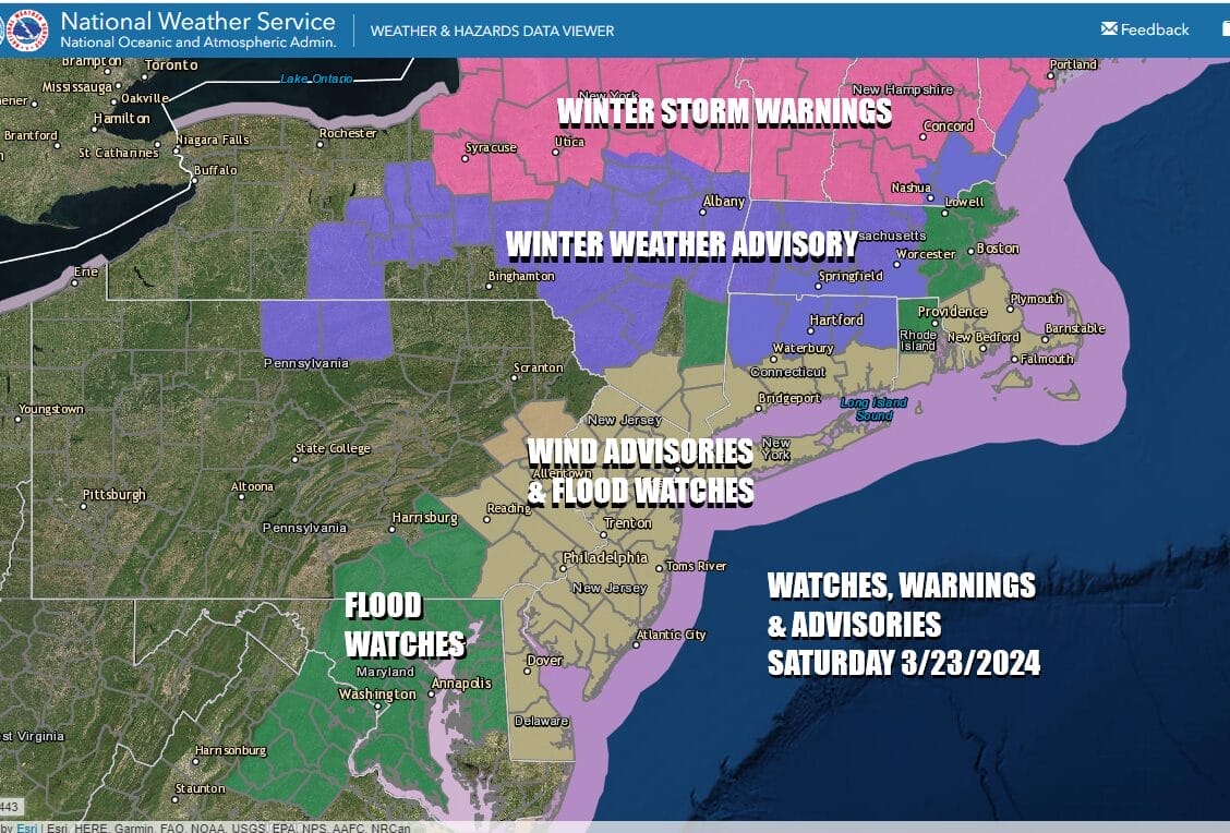
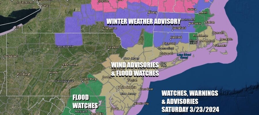
Low pressure is moving up the East Coast this morning and we are seeing heavy rain spreading northeastward from the Mid Atlantic to Southeastern New England. We have Flood Watches up from Northeast Virginia to Southeast New England. Also we have Wind Advisories up from Delaware and Southeastern Pennsylvania northeast to Southeast New England for winds gusting to 45 to 50 mph from the southeast into the this afternoon and then from the northwest this evening into tonight.
SATELLITE WITH LIGHTNING STRIKES

WEATHER RADAR

Low pressure is coming up the coast and expect the heaviest rain to occur from late morning until early evening from south to north. We could also see a few thunderstorms and possibly a squall line develop late this afternoon and evening, moving through NYC, Long Island, and points to the east. North of I-90 we have heavy wet snow and Winter Storm Warnings are up from Northern NY eastward to Maine with a foot plus of snow accumulation likely.

As far as rainfall totals are concerned, 2 to 3 inches are likely over a wide area from Delaware & Maryland to Southeast New England but there will be an area of 3 to possibly 4 inches in a zone just inland of the coast. Flash flood warnings are likely to be issued later today along with flood warnings for rising rivers and streams.

Temperatures today will rise into the 50s. Coastal flooding would normally be an issue in a situation like but thankfully the storm will pass through as we come off high tide and go into low tide later today. When we go back to high tide winds will have already shifted to the north. The risk for coastal flooding is actually higher Sunday and especially Monday thanks to an onshore flow developing, a full moon Sunday night, and peak tides Monday night.

At least the second half of the weekend is better. Skies will clear out overnight and Sunday should be a nice day with sunshine, a gusty north to northeast wind, and highs in the 40s to around 50 degrees. Monday will be dry with sunshine and again a gusty northeast wind and highs in the upper 40s to some lower 50s. A new storm forms between the coast and Bermuda Sunday and Monday but this storm is not going to have any impact other than creating that long fetch of northeasterly winds and the risk for coastal flooding developing at high tides beginning Sunday night and lasting into early Tuesday.
BE SURE TO DOWNLOAD THE FREE METEOROLOGIST JOE CIOFFI WEATHER APP &
ANGRY BEN’S FREE WEATHER APP “THE ANGRY WEATHERMAN!
MANY THANKS TO TROPICAL TIDBITS FOR THE USE OF MAPS
Please note that with regards to any severe weather, tropical storms, or hurricanes, should a storm be threatening, please consult your local National Weather Service office or your local government officials about what action you should be taking to protect life and property.
(Amazon is an affilate of Meteorologist Joe Cioffi & earns commissions on sales.)


