Heavy Rain Central South Jersey Ending
Heavy Rain Central South Jersey Ending
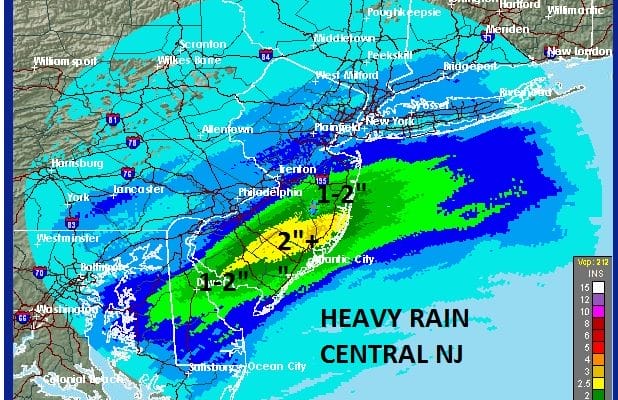
The rain today that moved through today concentrated its energy just to the south and east of the big cities. Heavy rain Central South Jersey reached over 2 inches in some places.
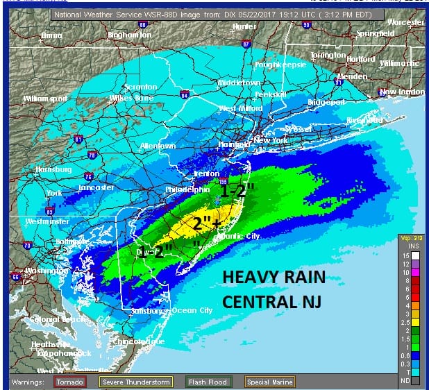
Satellite and radar loops show this first wave of low pressure beginning to slowly pull away to the northeast. Rains will continue for awhile longer before ending over Central and South Jersey. For areas to the northeast into Southern New England and Long Island the rain will last into the evening before pulling away to the northeast.
SATELLITE LOOP

REGIONAL RADAR

LOCAL RADAR NEW YORK CITY

LOCAL RADAR PHILADELPHIA


Once the rain pulls out we will have a leftover shower or two overnight. Temperatures went no where today in the mid 50s to lower 60s and will probably settle in the 50s overnight.
Tuesday the second in a series of wave will move out of the Gulf States and ride up the east coast. Right now it seems the bulk of the rain will pass offshore but it will graze Long Island and Central and South Jersey later Tuesday and Tuesday night. Areas to the north will see little if any rain and in fact some breaks of sun for North Jersey the Hudson Valley and inland Connecticut are not out of the question. If that happens those areas could see temperatures jump into the lower 70s Tuesday while where clouds dominate, temperatures will hold in the 60s.
GFS RAINFALL FORECAST THURSDAY AND THURSDAY NIGHT

Wednesday we may get a break for awhile with clouds and some sun but another low moves out of the Plains and into the Northeast bringing showers and some possible thunderstorms on Thursday. Friday is on course for leftover clouds and some leftover early showers. As to the holiday weekend I think Saturday may wind up being the best of the 3 days with no rain but Sunday and Monday remain uncertain with Monday offering the best chance for rain.
 GET JOE A CIGAR IF YOU LIKE

LANDSCAPE COMPANIES FOR YOUR NEEDS
LONG ISLAND ROCKLAND COUNTY Connecticut

![]()

ROCKLAND COUNTY TRI STATE SNOW REMOVAL JOHNSTOWN PA


FiOS1 News Weather Forecast For Long Island
FiOS1 News Weather Forecast For New Jersey
FiOS1 News Weather Forecast For Hudson Valley
NATIONAL WEATHER SERVICE SNOW FORECASTS
LATEST JOESTRADAMUS ON THE LONG RANGE
Weather App

Don’t be without Meteorologist Joe Cioffi’s weather app. It is really a meteorologist app because you get my forecasts and my analysis and not some automated computer generated forecast based on the GFS model. This is why your app forecast changes every 6 hours. It is model driven with no human input at all. It gives you an icon, a temperature and no insight whatsoever.
It is a complete weather app to suit your forecast needs. All the weather information you need is right on your phone. Android or I-phone, use it to keep track of all the latest weather information and forecasts. This weather app is also free of advertising so you don’t have to worry about security issues with your device. An accurate forecast and no worries that your device is being compromised.
Use it in conjunction with my website and my facebook and twitter and you have complete weather coverage of all the latest weather and the long range outlook. The website has been redone and upgraded. Its easy to use and everything is archived so you can see how well Joe does or doesn’t do when it comes to forecasts and outlooks.
Just click on the google play button or the apple store button on the sidebar for my app which is on My Weather Concierge. Download the app for free. Subscribe to my forecasts on an ad free environment for just 99 cents a month.
Get my forecasts in the palm of your hand for less than the cost of a cup of Joe!