Heavy Rain 1-2 Inches Tuesday, Patchy Rain Into Tonight
Heavy Rain 1-2 Inches Tuesday, Patchy Rain Into Tonight
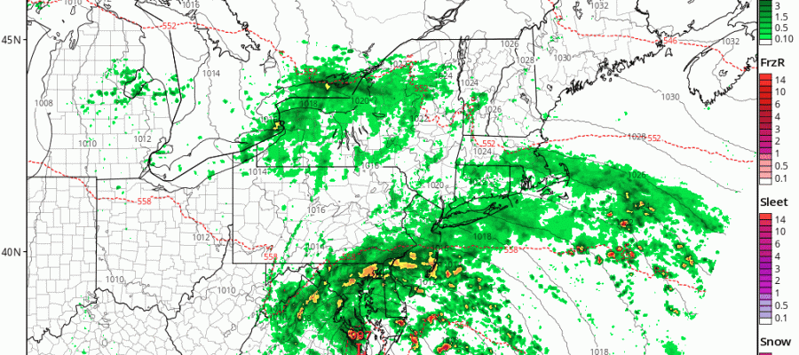
Low pressure both at the surface and aloft is producing heavy rains today across much of the Southeastern US with flooding occuring of parts of Eastern South Carolina. Judging from the satellite loop the upper air system is not making much northward progress. Some of the lead rain from last night has been weakening as it moves northward and the local radars below show some patchy rain approaching NYC Long Island and Northern New Jersey at the moment. We suspect that the rain will be patchy in nature today and for the first part of tonight as the HRRR model indicates.
HRRR MODEL RAINS TONIGHT CLICK TO ANIMATE

During the day Tuesday is when the heaviest rains fall. The rain will be moving into Southern & Central New Jersey and Southeastern Pennsylvania during the morning hours and reach NYC around 10 or 11am and then continue for the afternoon and evening
HEAVY RAIN NAM MODEL 10AM-4PM TUESDAY CLICK TO ANIMATE

If this plays out according to plan 1 to 2 inches of rain will be common place and there could be a few thunderstorms in the mix as well as tropical air surges up the coast. A southeast to east wind will keep temperatures just into the 50s on Tuesday.
SATELLITE LOOP

REGIONAL RADAR

LOCAL RADAR NEW YORK CITY

LOCAL RADAR PHILADELPHIA


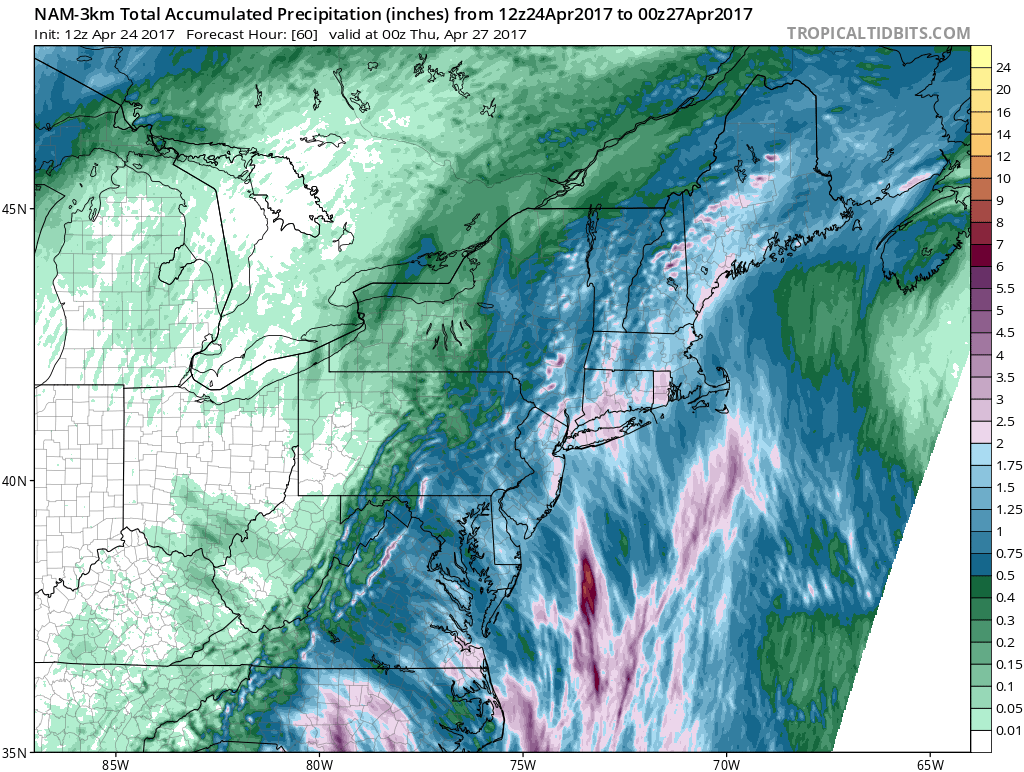
You can see the blotchy rain bands on the local radars this afternoon. The solid rain on the regional radar above remains to the south in Virginia and North Carolina but it is making slow northward progress. As far as rainfall amounts are concerned, the GFS is the most conservative with .50 to 1.25 inches while the Canadian model goes crazy with 2 to 4 inches or more everywhere. The NAM model splits the difference to a large degree.
HEAVY RAIN NAM RAINFALL FORECAST
By Wednesday low pressure will be northeast of us so look for leftover clouds and temperatures in the 60s to near 70. Some breaks of sun are possible and so is a passing leftover shower. Thursday will be warmer with some sunshine and highs will reach the 70s. Friday looks warm too with highs in the 70s to near 80 along with the chance for a late shower or thunderstorm. The weekend is going to hinge on what a cold front does as it gets hung up pretty much right overhead. South of that front it will be in the 80s while north of it in the 60s. More on the longer range later today.
 GET JOE A CIGAR IF YOU LIKE

LANDSCAPE COMPANIES FOR YOUR NEEDS
LONG ISLAND ROCKLAND COUNTY Connecticut

![]()

ROCKLAND COUNTY TRI STATE SNOW REMOVAL JOHNSTOWN PA


FiOS1 News Weather Forecast For Long Island
FiOS1 News Weather Forecast For New Jersey
FiOS1 News Weather Forecast For Hudson Valley
NATIONAL WEATHER SERVICE SNOW FORECASTS
LATEST JOESTRADAMUS ON THE LONG RANGE
Weather App

Don’t be without Meteorologist Joe Cioffi’s weather app. It is really a meteorologist app because you get my forecasts and my analysis and not some automated computer generated forecast based on the GFS model. This is why your app forecast changes every 6 hours. It is model driven with no human input at all. It gives you an icon, a temperature and no insight whatsoever.
It is a complete weather app to suit your forecast needs. All the weather information you need is right on your phone. Android or I-phone, use it to keep track of all the latest weather information and forecasts. This weather app is also free of advertising so you don’t have to worry about security issues with your device. An accurate forecast and no worries that your device is being compromised.
Use it in conjunction with my website and my facebook and twitter and you have complete weather coverage of all the latest weather and the long range outlook. The website has been redone and upgraded. Its easy to use and everything is archived so you can see how well Joe does or doesn’t do when it comes to forecasts and outlooks.
Just click on the google play button or the apple store button on the sidebar for my app which is on My Weather Concierge. Download the app for free. Subscribe to my forecasts on an ad free environment for just 99 cents a month.
Get my forecasts in the palm of your hand for less than the cost of a cup of Joe!


