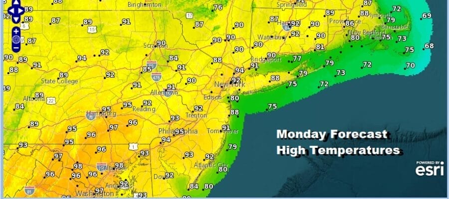
Heatwave in the Northeast Continues All Week,
90 Degree Plus Highs, High Humidity

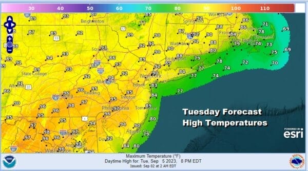
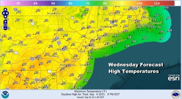
Heatwave in the Northeast Continues All Week,
90 Degree Plus Highs, High Humidity

Well it was a bit of a surprise to see a couple of lines of thunderstorms moving southeastward from Upstate NY this morning. An upper trough is moving through from the northwest and we are completing the transition into a hot humid air mass that will be with us through at least Thursday and possibly beyond that. In the meantime these storms will play through this morning and then it is hot and humid with sunshine taking highs into the 90s with high humidity. There should not be any thunderstorms to speak of late today or into this evening.
SATELLITE WITH LIGHTNING STRIKES

WEATHER RADAR

Not much is moving around in the upper air patterna across the US and Canada at the moment. We have post tropical cyclone Idalia southeast of Nova Scotia moving northwestward and forecast to weaken today and finally disappear over the next 2 days. This is essentially creating a bit of a log jam and holding the upper high in the Eastern US in place. This creates hot and humid weather in the East.

It also means that the next cold front will get even close until late Thursday so the next 3 days, Tuesday Wednesday and Thursday will be hot and humid with sunshine each day and highs reaching the low and middle 90s. We may see some record highs being set especially in areas north and northeast of NYC and in stations with data that only goes back a relatively small number of years. Either way it is a heatwave and 5 or 6 days in a row of 90 degree highs for much of the Northeast and Northern Mid Atlantic states.
Thursday and Friday will also bring an upper trough and cold front close enough to set off some late day thunderstorms each of those days. Highs both Thursday and Friday will be in the 90s. The question becomes whether the front goes offshore and weather conditions improve for the weekend along with a cool down. That may depend on what happens in the tropics.
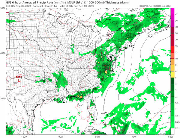
A strong tropical wave moving westward across the Tropical Atlantic is forecast by all the models to develop into a tropical storm and possibly a hurricane down the road. Those models show this system approaching the Bahamas next weekend and early next week as the gfs loop shows above. This may cause the ridge in the Atlantic ocean to be stronger and stall the front along the East Coast all next weekend. However there are also systems upstream in Canada that could overpower this idea and keep both the Atlantic ridge and any tropical system far offshore. There is much to watch here in the coming days regarding this system. In the meantime it is hot and humid all week long.
BE SURE TO DOWNLOAD THE FREE METEOROLOGIST JOE CIOFFI WEATHER APP &
ANGRY BEN’S FREE WEATHER APP “THE ANGRY WEATHERMAN!
MANY THANKS TO TROPICAL TIDBITS FOR THE USE OF MAPS
Please note that with regards to any severe weather, tropical storms, or hurricanes, should a storm be threatening, please consult your local National Weather Service office or your local government officials about what action you should be taking to protect life and property.
(Amazon is an affilate of Meteorologist Joe Cioffi & earns commissions on sales.)


