
Heatwave Day 6 Less Humid
[brid video=”56082″ player=”6390″ title=”video1469496391″]
Now that the humidity has been wrung out of the atmosphere after yesterday’s thunderstorms, we will see another day of hot temperatures with highs today between 90 and 95. This will be the 6th consecutive day of 90 degrees of higher for most (but not all) of the area. Yesterday Newark hit 99 which was a record high while Islip hit 86 which broke the streak of 90 plus days there at 4.
Satellite loop shows the cold front well offshore and the flow of dry air is from the northwest though it is not particularly strong. We expect lots of sunshine today and no thunderstorms are forecast.
Heatwave Day 6 Satellite Loop

Radars are quiet this morning across the northeast. There might be some scattered showers or thunderstorms that develop across the Middle Atlantic States today but nothing widespread is forecast there and none of it is coming here.
Heatwave Day 6 Radar Loop


Wednesday looks like another sunny hot day with moderate humidity. Highs will be in the upper 80s to lower 90s on average. Then on Thursday we will see the next front approach which means hot and humid with thunderstorms possible and highs in the 90s. Now this front is forecast to stall. Models have been showing a wave moving out of the Tennessee Valley and up the east coast Thursday night and Friday with an area of rain. We can only hope this is true because it will mean a good soaking rain for the area in places that need it the most. (Long Island in particular).
Heatwave Day 6 GFS MODEL FRIDAY 2PM
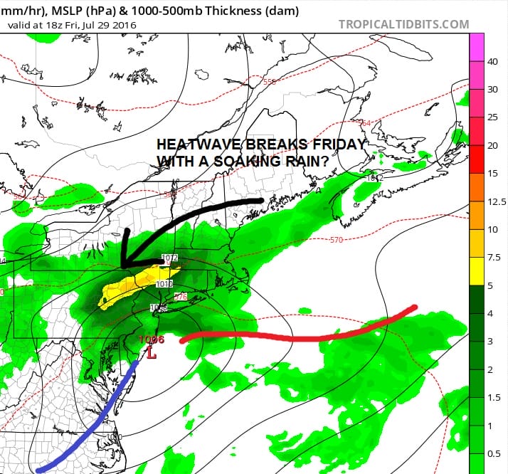
If this plays out, it will mean that Thursday is the last day of 90s and Friday temperatures will probably not get out of the 70s and then followed by a nice dry weekend.
FiOS1 News Weather Forecast For Long Island
FiOS1 News Weather Forecast For New Jersey
FiOS1 News Weather Forecast For Hudson Valley
NATIONAL WEATHER SERVICE SNOW FORECASTS
LATEST JOESTRADAMUS ON THE LONG RANGE
Weather App

Don’t be without Meteorologist Joe Cioffi’s weather app. It is really a meteorologist app because you get my forecasts and my analysis and not some automated computer generated forecast based on the GFS model. This is why your app forecast changes every 6 hours. It is model driven with no human input at all. It gives you an icon, a temperature and no insight whatsoever.
It is a complete weather app to suit your forecast needs. All the weather information you need is right on your phone. Android or I-phone, use it to keep track of all the latest weather information and forecasts. This weather app is also free of advertising so you don’t have to worry about security issues with your device. An accurate forecast and no worries that your device is being compromised.
Use it in conjunction with my website and my facebook and twitter and you have complete weather coverage of all the latest weather and the long range outlook. The website has been redone and upgraded. Its easy to use and everything is archived so you can see how well Joe does or doesn’t do when it comes to forecasts and outlooks.
Just click on the google play button or the apple store button on the sidebar for my app which is on My Weather Concierge. Download the app for free. Subscribe to my forecasts on an ad free environment for just 99 cents a month.
Get my forecasts in the palm of your hand for less than the cost of a cup of Joe!

MENTION JOE CIOFFI AND GET A 5% DISCOUNT


