Heat Humidity Severe Weather Risks Hot Humid Weekend

Today will be day three of what looks to be a 7 day stretch of 90 plus highs. Yesterday was a brutal day with highs that reached mid to upper 90s. Parts of New Jersey like Newark and Sommerville got to 100 degrees. Look for highs today to reach the low to middle 90s at least. What might help to hold temperatures down a degree or two from yesterday is an approaching front and more of a southwest wind verses a west wind.

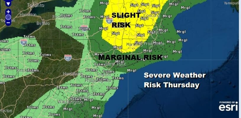
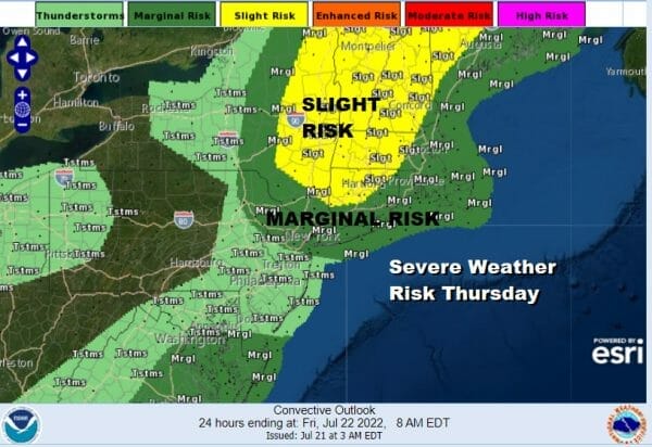
This weather front is not an impressive one nor is the upper trough that is moving through Southeastern Canada. Overnight forecasts from the Storm Prediction Center have most of the area either in a general risk for thunderstorms and a marginal risk for severe. Should the thunderstorms materialize, there is the chance for some isolated severe thunderstorms in the mix.
SATELLITE

WEATHER RADAR

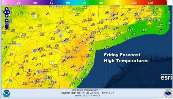
There isn’t much in the way of cooler or drier air behind this weather front so we basically go from hot air mass to hot air mass. Friday will be a day of some sunshine. It will be hot and humid though the dew points might be a shade lower than today. It isn’t enough to make a huge difference. Highs Friday will be in the low to middle 90s.
There is a weak upper trough that will be moving through Friday and that opens the door for some scattered late day thunderstorms and the Storm Prediction Center has a general thunderstorm risk with a marginal risk from Northern New Jersey and the Hudson Valley northwest into Pennsylvania and the Catskills.
The weekend leaves us with more of the same heat and humidity. Saturday will be hot and humid with sunshine. Highs will be in the low to mid 90s. Sunday will be very hot and humid with sunshine taking highs to the mid 90s to near 100 degrees. Another cold front will be arriving later Monday with some showers and thunderstorms but it will be in the 90s ahead of it. Perhaps we can see some temperature and humidity relief after that front moves on through.
BE SURE TO DOWNLOAD THE FREE METEOROLOGIST JOE CIOFFI WEATHER APP &
ANGRY BEN’S FREE WEATHER APP “THE ANGRY WEATHERMAN!
MANY THANKS TO TROPICAL TIDBITS & F5 WEATHER FOR THE USE OF MAPS
Please note that with regards to any severe weather, tropical storms, or hurricanes, should a storm be threatening, please consult your local National Weather Service office or your local government officials about what action you should be taking to protect life and property.


