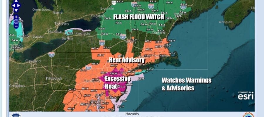
Heat Advisories & Excessive Heat Continues
Severe Weather & Flooding From Beryl Upstate NY New England

Heat Advisories & Excessive Heat Continues
Severe Weather & Flooding From Beryl Upstate NY New England
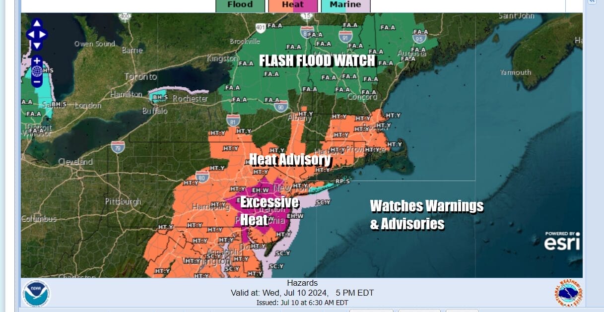
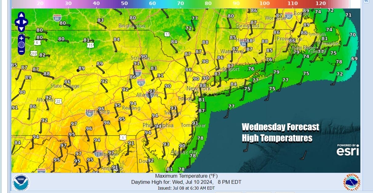
Thanks to the remnant low of Hurricane Beryl, we are going to see all sorts of weather today across the Northeast. Eastern Pennsylvania to Southern New England south to Maryland, Delaware, & Virginia it is all about excessive heat warnings and heat advisories. High temperatures this afternoon once again will reach the low to middle 90s on average with heat indices running between 100 & 105.
Northwest of the coast in Northern Pennsylvania and Southern NY east into Northwestern New England we have the remnant low of Beryl tracking across this region. South of the low track will be an area of severe weather risk and the Storm Prediction Center has indicated an enhanced risk (30%) of severe weather across Southern New York and Northern Pennsylvania.

Elevated risk for severe weather and tornadoes extends into Vermont and New Hampshire with isolated severe thunderstorms possible east into Maine and Eastern Massachusetts, south to Connecticut, Southeastern NY, Northern New Jersey, the rest of Pennsylvania south into Maryland and Virginia. Tornado risk is also elevated with a 10 percent risk being indicated for the enhanced risk zone.
SATELLITE WITH LIGHTNING STRIKES

WEATHER RADAR

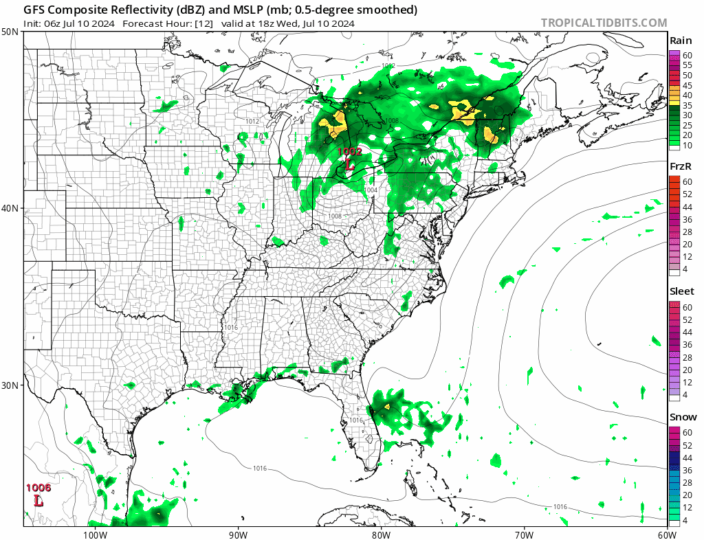
Ahead of all this we will have ample daytime heating and a very unstable atmosphere. Add to this the remnants of Beryl and often times with tropical systems, that atmosphere has a little extra juice to work with. For Eastern Pennsylvania to Southern New England watch for some pop up scattered thunderstorms late today into this evening and that chance for an isolated severe storm or two.

The NAM model shows a rather aggressive line of thunderstorms developing from Central to NY to Central Pennsylvania south into Virgnia late this afternoon and evening and then weakening as it heads to the coast. In Northern NY, Vermont and New Hampshire, 2 to 4 inches of rain is possible north of the low track later today and tonight and flash flood watches are up for that area.
Thursday will be another hot humid day for Eastern Pennsylvania to Southern New England with just the outside chance for a pop up shower or thunderstorms. Winds will be more southerly around the Bermuda high offshore so high temperatures will probably be a little lower but we will still reach upper 80s and lower 90s with high humidity.

There is an upper low in the Southwest Atlantic that will move around the backside of that high and that will likely bring clouds and an increasing chance for rain and thunderstorms later Friday and Friday night. Highs Friday will be in the 80s but it will be very humid. We could see anywhere from 3/4 inch to an inch and a half of rain with some locally higher amounts. Saturday sees sunshine returning along with highs in the upper 80s and lower 90s. Sunday will be hot with some sunshine and the chance for late thunderstorms. Highs will be in the 90s.
BE SURE TO DOWNLOAD THE FREE METEOROLOGIST JOE CIOFFI WEATHER APP &
ANGRY BEN’S FREE WEATHER APP “THE ANGRY WEATHERMAN!
MANY THANKS TO TROPICAL TIDBITS FOR THE USE OF MAPS
Please note that with regards to any severe weather, tropical storms, or hurricanes, should a storm be threatening, please consult your local National Weather Service office or your local government officials about what action you should be taking to protect life and property.
(Amazon is an affilate of Meteorologist Joe Cioffi & earns commissions on sales.)


