
Another Tough Day of Heat & Humidity
Thunderstorm Chances Increase Next Several Days

Another Tough Day of Heat & Humidity
Thunderstorm Chances Increase Next Several Days
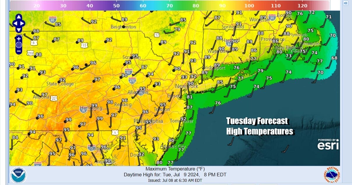
It is another day in the steam bath. Yesterday we saw highs in the low 90s from New York City north and east and highs in the mid to upper 90s from New York City south and west. Today will be a repeat performance with sunshine and high humidity. Thunderstorm activity will be scattered in most places with some downpours possible in coastal communities along a sea breeze front.

However we do have some severe weather risk for parts of Southern and Southeastern New England for isolated severe thunderstorms this afternoon and evening. Once the evening hours are done thunderstorm activity should disappear and we have another every warm and humid night. Most lows will be in the upper 60s to middle 70s.
SATELLITE WITH LIGHTNING STRIKES

WEATHER RADAR

The remnants of Hurricane Beryl have taken the form of a remnant low that is moving through the Middle Mississippi Valley and heading for the lower Great Lakes. From there the low will take a track across Southeastern Canada and Northern New England Wednesday and Thursday. The low tracking to the north brings heavy rains to Upstate NY and New England mainly north of Interstate 90. In this area several inches or more of rain are possible later Wednesday into early Thursday morning.

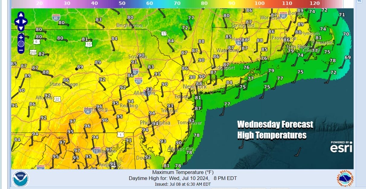
To the south we have a feeder of tropical moisture that sets up along the East Coast and this could bring higher chances for some thunderstorms beginning later Wednesday and also for Thursday and Friday. However it is not anything continuous so when it is not raining the steam bath weather continues. Wednesday’s highs will again reach to the low to middle 90s with high humidity.
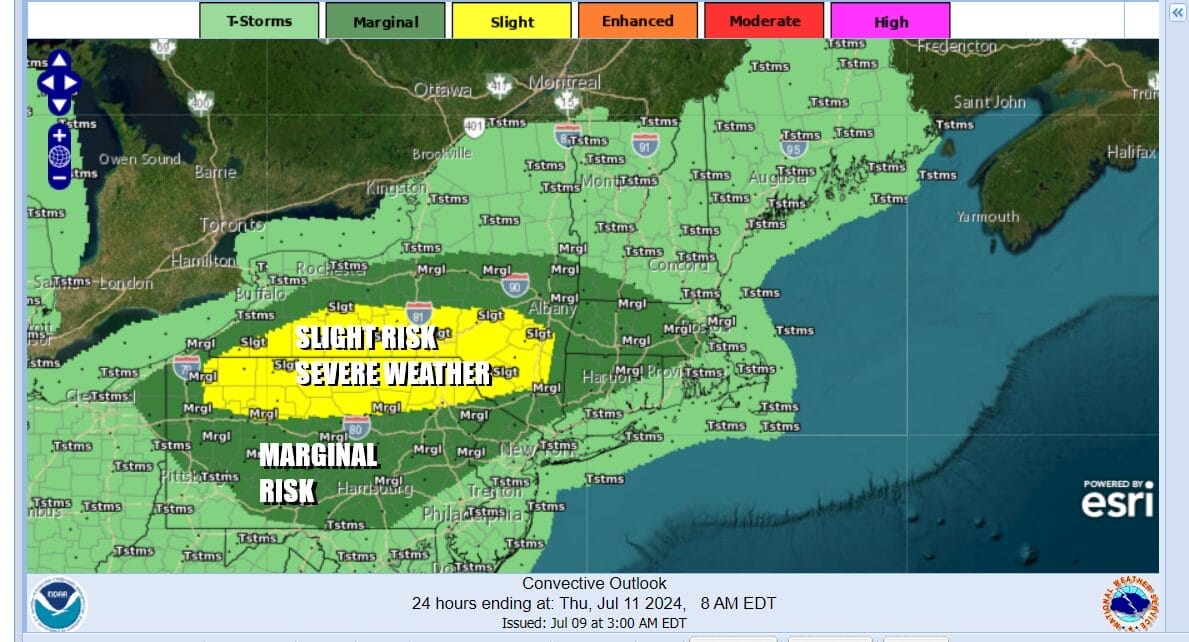
There is severe weather risk for inland areas from Northern New Jersey and the Hudson Valley where there are risk for isolated severe thunderstorms later Wednesday and Wednesday night. The risk areas are higher in Northern Pennsylvania and Southern New York and there is also elevated tornado risk.
The remnant low of Beryl moves away Thursday to the northeast so this leaves us in the same humid air mass. Steam bath conditions continue with some sunshine taking highs into the upper 80s and lower 90s and we will throw in the chance for a scattered thunderstorm or two. The risk for thunderstorms increases Friday especially along the coastal plain and with more clouds highs will be in the mid to upper 80s. Over the weekend it looks to be steamy with high humidity, some sunshine, scattered thunderstorms, and highs in the upper 80s and lower 90s. We do not see a break in the humidity anytime soon. In fact weather models seem to backing away from a cold front arriving Monday with aggressive humidity relief for next week.
BE SURE TO DOWNLOAD THE FREE METEOROLOGIST JOE CIOFFI WEATHER APP &
ANGRY BEN’S FREE WEATHER APP “THE ANGRY WEATHERMAN!
MANY THANKS TO TROPICAL TIDBITS FOR THE USE OF MAPS
Please note that with regards to any severe weather, tropical storms, or hurricanes, should a storm be threatening, please consult your local National Weather Service office or your local government officials about what action you should be taking to protect life and property.
(Amazon is an affilate of Meteorologist Joe Cioffi & earns commissions on sales.)


