Gusty Winds Continue Much of the Week Very Cold As Storm Passes South & East

Gusty Winds Continue Much of the Week Very Cold As Storm Passes South & East
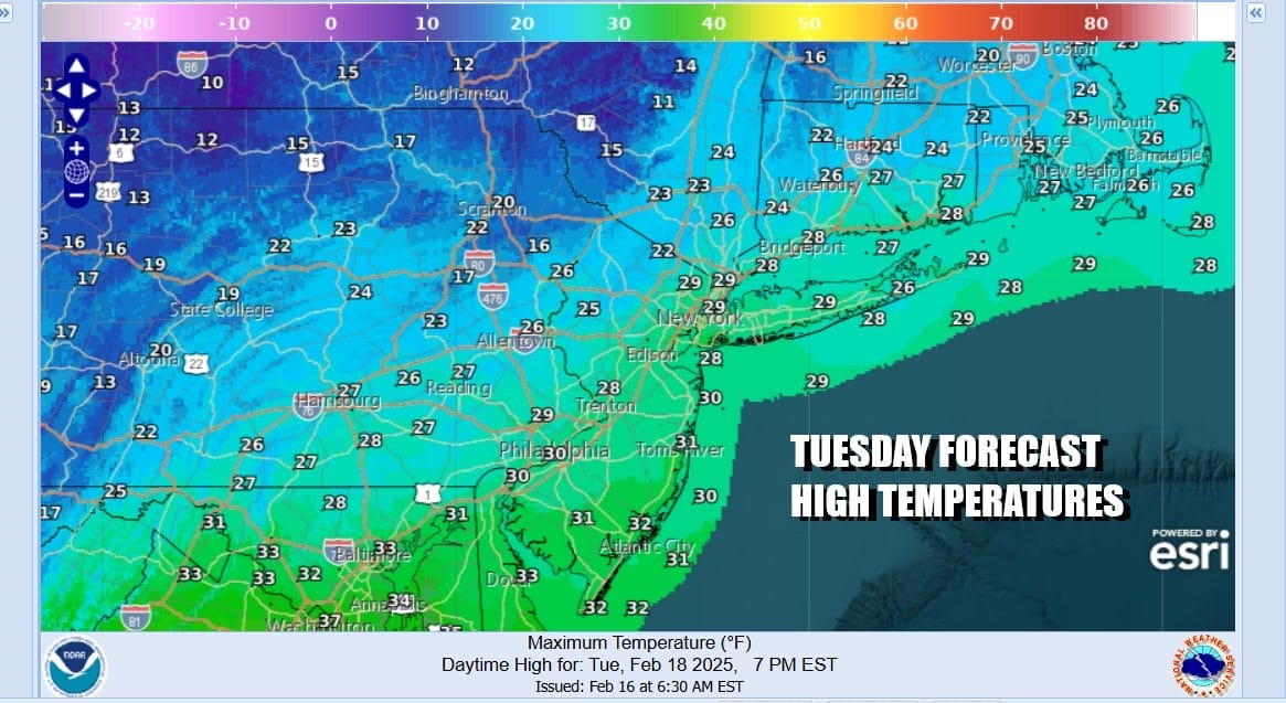
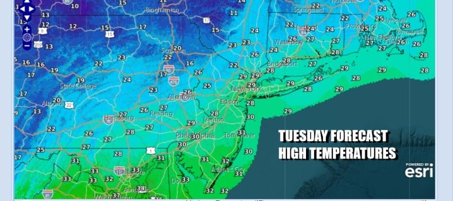
Very cold air covers the entire Eastern US as well as the Midwest, Ohio Valley, the Plains south to Texas and east to North Florida. Cold weather will continue and today will be another day of gusty winds. While the winds are off their peak gusts yesterday of 50 mph or more, we will still see gusts in the 30 to 40 mph range today. Couple that with ineffective sunshine and highs in the upper 20s and lower 30s, and you have all the puzzle pieces put together for a cold winter day indeed.
SATELLITE WITH LIGHTNING STRIKES

WEATHER RADAR

While we sit in cold air all week long, we are also watching a new storm system develop in the Southern Plains. That storm system will move eastward along the Gulf Coast. This is another instance of heavy snow that is forecast to fall from Kansas and Oklahoma eastward to Virginia and North Carolina. This has been the signature of storm tracks all winter long.

It will be no different this time around as this storm will make the turn up to the Southeast US coast, however the upper air flow along the east coast is mostly west southwest and that will carry the low offshore. Snow will probably not make it much further north than the Delmarva Peninsula. The heaviest snow will likely be in Southeast Virginia to Eastern North Carolina.
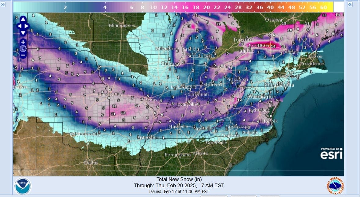
There will be an upper air low that will be moving from west to east across Southern Pennsylvania and Southern New Jersey Thursday. This could set off what I would describe as nuisance snow showers or an area of light snow that perhaps whitens the ground up in spots. Otherwise there is no significant risk for accumulating snows north of the Delmarva Peninsula.
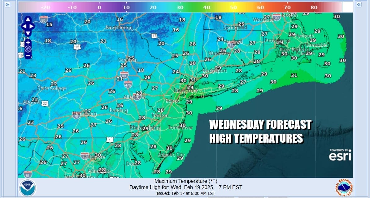
This leaves us with sunshine giving way to some high clouds Wednesday. It will be a very cold day and still on the breezy side with highs probably not out of the 20s. The same holds for Thursday as we will see lots of clouds around. Im going to mention that chance for some passing snow showers that could whiten the ground. High temperatures again will not be out of the 20s. Cold weather lasts into Friday but we should see a dry weather weekend along with moderating temperatures.
BE SURE TO DOWNLOAD THE FREE METEOROLOGIST JOE CIOFFI WEATHER APP &
ANGRY BEN’S FREE WEATHER APP “THE ANGRY WEATHERMAN!
MANY THANKS TO TROPICAL TIDBITS FOR THE USE OF MAPS
Please note that with regards to any severe weather, tropical storms, or hurricanes, should a storm be threatening, please consult your local National Weather Service office or your local government officials about what action you should be taking to protect life and property.


