DOWNLOAD MY NEW FREE JOESTRADAMUS WEATHER APP FOR ALL DEVICES
THE APP IS ABSOLUTELY FREE TO ALL BUT CONSIDERING SUBSCRIBING TO PATREON FOR A WEATHER EXPERIENCE FREE OF ADS, EXCLUSIVE VIDEOS FOR MEMBERS ONLY AND MUCH MORE…STARTS AT $2 A MONTH..MESSAGE ME AT ANY TIME
Gloomy Wednesday More Waves of Low Pressure Ahead
After a brief appearance of some sunshine on Tuesday we are back in the gloom today with and onshore flow, clouds have moved in and this is where we are going to be sitting all day. A warm front is setting up to our south and that front will make its move northward tonight into Thursday morning with a few showers. This is the first of several systems that lie ahead that will keep us in this cloudy gloomy pattern overall through the weekend. However there is some hope for another bit of a break on Thursday.
SATELLITE

REGIONAL RADAR

On the radars this morning we are seeing some showers moving through upstate NY & Central New England. There might be some patchy light rain showers or some drizzle that shows up later today but for the most part we won’t see much rain wise. Temperatures today are going nowhere with highs just into the 50s.
LOCAL RADAR NEW YORK CITY

LOCAL RADAR PHILADELPHIA


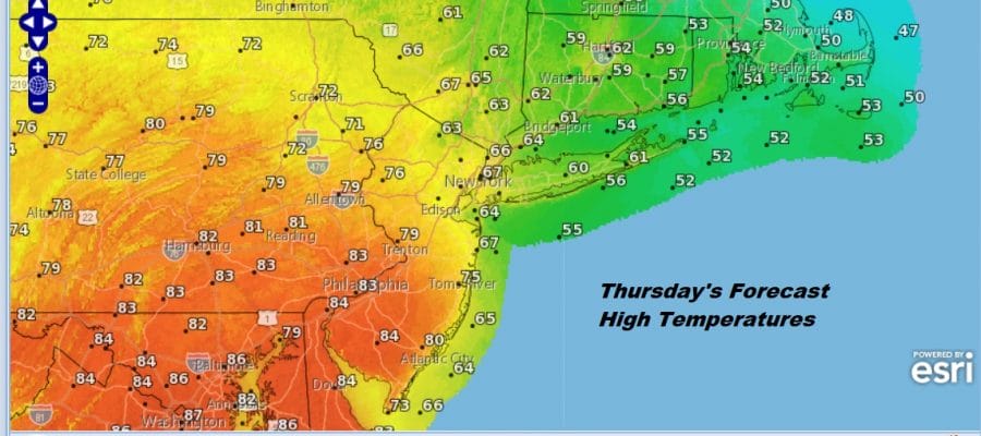
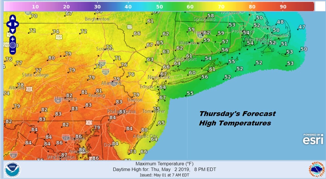
Tonight into Thursday it is about the warm front and how far north does it get. Weather models suggest that the warm front gets pinched off around NYC which means that while we could see 80s reaching up into Central New Jersey with some sunshine, areas from Northern New Jersey NYC north and east won’t see temperatures higher than the 60s with lots of clouds. I’ve thrown in the chance for an isolated shower or thunderstorm in the warmer air late Thursday afternoon and evening as a weak cold front starts to slide through.
Thursday night into Friday it is back to the onshore flow and again it is about the warm front on Friday and how far north it gets. Friday the front may have a tougher time so we would see temperatures in the 70s in Central and South Jersey and 50s to lower 60s east of NYC into Southern New England and Long Island. There is the chance for a few showers or a thunderstorm as a cold front goes by.
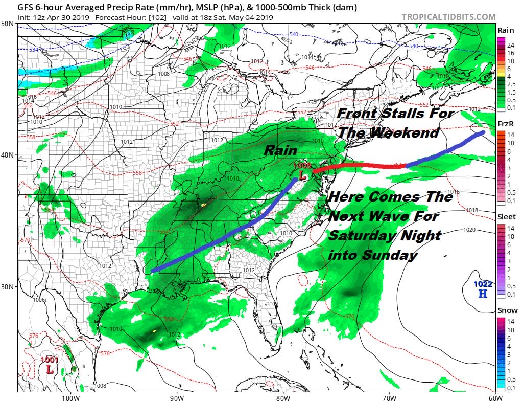
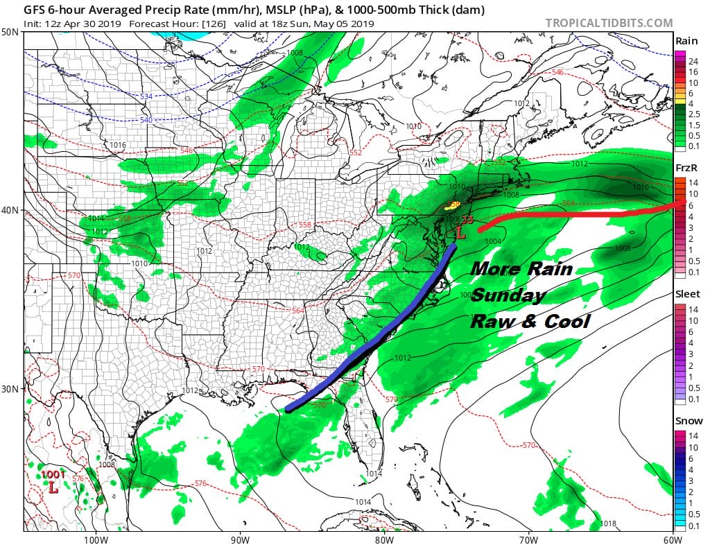
Nothing has changed regarding the weekend. Friday’s cold front stalls and we see waves of low pressure moving along. Saturday will be cloudy with rain developing later in the afternoon and we will see rain continue into at least part of Sunday. Temperatures will eventually be impacted by a northeast flow and we will go from highs in the 60s on Saturday to just into the 50s on Sunday. The weekend looks raw and gloomy for sure.
it looks like we could see some improvement early next week but it is all about the blocking pattern that is set up in the North Atlantic and when does it break down. Right now the block holds into the middle of next week so after a break in the action Monday and Tuesday we could be back to clouds and showers later next week.
MANY THANKS TO TROPICAL TIDBITS FOR THE USE OF MAPS
Please note that with regards to any tropical storms or hurricanes, should a storm be threatening, please consult your local National Weather Service office or your local government officials about what action you should be taking to protect life and property.


