Gloom & Doom Rain Into Friday
Rain or Rain Changing to Snow Later Sunday Into Monday

Gloom & Doom Rain Into Friday
Rain or Rain Changing to Snow Later Sunday Into Monday
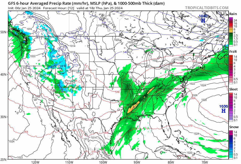
The gloom & doom scenario continues and the satellite loop shows that as one round of clouds moves out, another surge and another wave of moisture heads in. This might allow a brief break in the rain that moved through overnight but look for another round of rain to develop later today and last surge of rain will move through this evening and overnight. In the meantime today temperatures are trying to warm and highs will be mostly in the 50s. Radars will remain on the busy side following the areas of rain along from west to east.
SATELLITE WITH LIGHTNING STRIKES

WEATHER RADAR

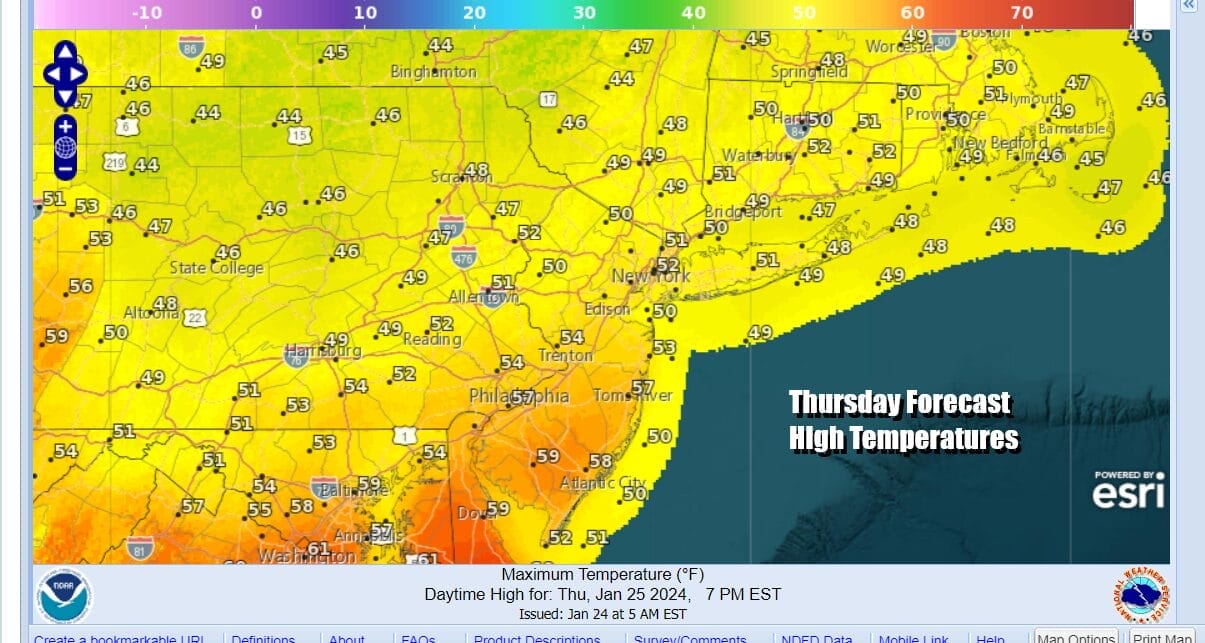
The overnight rain should be gone by daybreak but that leaves us Friday with a backdoor cold front that will be lying across the area from east to west. To north of that frontal boundary temperatures will be in the mid to upper 40s for highs and that looks to be from NYC and Long Island northward while areas from Southern New Jersey and Southern Pennsylvania southward will be in the upper 50s and lower 60s.

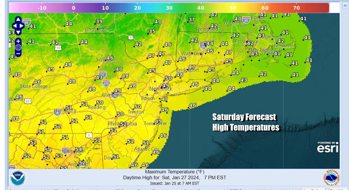
The areas north of the frontal boundary will likely sit in clouds all day long while to the south from Southern Pennsylvania and Southern New Jersey southward, breaks of sunshine will likely develop. Friday night the front will pass through leading to cooler temperatures for Saturday. Saturday will also be the better of the two weekend days with some sunshine. Highs will be in the mid 40s north to some lower 50s south.
While all this is going on we continue to see heavy rains across the Gulf States and into the Southeast US. Rainfall amounts have been excessive in this area averaging 5 to 6 inches or more in places and producing lots of flash flooding. The last low in this series of 4 will be moving across the Gulf States, and then head across the Appalachians and finally emerging off the Virginia coast Sunday night into Monday morning.
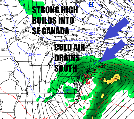
This set up is complicated by cold strong high pressure building into Eastern Canada Sunday and that will allow colder air to drain southward into the Northeast and Northern Mid Atlantic. This seems a set up you see more often in March into early April where elevation becomes a driver for snow accumulation. In this particular case we are talking about borderline conditions developing regarding rain and snow for many areas. We look for rain to develop Sunday and then changing over to snow from north to south Sunday night into Monday morning. Specific accumulation ideas are impossible at the moment since a lot depends on just exactly what we are dealing with here. Intensity will be important as will be temperatures. It is probably safe to say that inland elevated areas stand a chance to see accumulating wet snow. Along the coast and in the big cities from Washington to NYC probably sit along the edge of rain and snow for much of this event. We will likely need another day or even two to figure out how this plays.
BE SURE TO DOWNLOAD THE FREE METEOROLOGIST JOE CIOFFI WEATHER APP &
ANGRY BEN’S FREE WEATHER APP “THE ANGRY WEATHERMAN!
MANY THANKS TO TROPICAL TIDBITS FOR THE USE OF MAPS
Please note that with regards to any severe weather, tropical storms, or hurricanes, should a storm be threatening, please consult your local National Weather Service office or your local government officials about what action you should be taking to protect life and property.
(Amazon is an affilate of Meteorologist Joe Cioffi & earns commissions on sales.)


