
Gloom & Doom On The Way Friday Through Sunday
2 Storm Systems Headed Our Way

Gloom & Doom On The Way Friday Through Sunday
2 Storm Systems Headed Our Way
A weather front will be approaching and moving through today. The front is on the weak side so we will see the chance for a few scattered showers as two bands of rain move through. It won’t amount to much and in between those bands we will see some sunshine in the mix. Temperatures today will be able to warm up back into the lower 60s in most places. Cooler temperatures in the 50s are likely along south and east facing shorelines. Once the front passes we should see skies partially clear tonight with most lows in the 40s except for a few 30s well inland.
SATELLITE

WEATHER RADAR

High pressure will be building into the Northeast Thursday and it should make for a decent day that has some sunshine. However we will start to pay attention to the developing onshore flow that will start to take hold later Thursday and then lock itself in Friday. Temperatures Thursday will be in the low to middle 60s though we will start to see a southeast wind take hold as the day wears on.

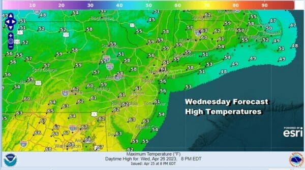
Two storm systems are on the way for Friday and the weekend. The first low takes a track to the west side of the Appalachians and thanks to the blocking pattern, we will see that low eventually reform off the Virginia coast. It is not a particularly strong system but with a high to the north and an east wind, expect gloom and doom to take hold with lots of clouds Friday. Temperatures will mostly be in the upper 50s and lower 60s.
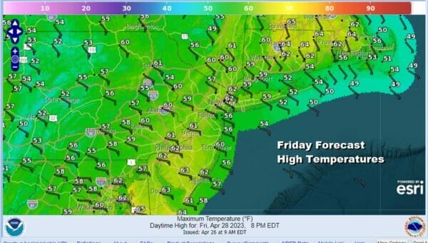
There will be some light rain or drizzle around Friday as the steadier rain initially goes to the west but later Friday night into Saturday afternoon a steadier round of rain will develop and move through. Between the rain and the onshore flow east wind, temperatures will be hard pressed to get out of the 50s Saturday making it a rather miserable day.
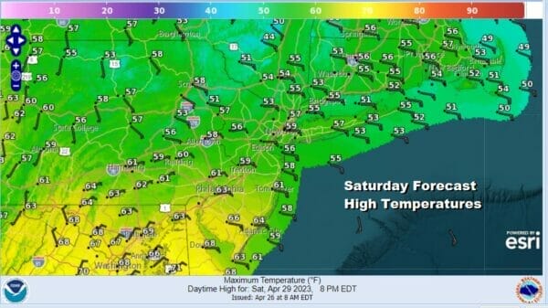
There might be a brief break in the rain Saturday night however a second storm system will be riding up the east side of the Appalachians Sunday and that will bring more rain on the scene. There is some spread in the track of the low as to whether it will run northward inland, along the coast or just offshore. Any of these options will mean more rain for later Sunday into Monday morning however it could impact temperatures to an extent. We will figure that part of the puzzle out later but between the two systems, it is likely that we could see at least an inch or 2 of rain and possibly some locally higher amounts, spread out over the 72 hour time frame. Once the system goes by, it leaves us with a chilly but mostly dry first half of next week.
BE SURE TO DOWNLOAD THE FREE METEOROLOGIST JOE CIOFFI WEATHER APP &
ANGRY BEN’S FREE WEATHER APP “THE ANGRY WEATHERMAN!
MANY THANKS TO TROPICAL TIDBITS & F5 WEATHER FOR THE USE OF MAPS
Please note that with regards to any severe weather, tropical storms, or hurricanes, should a storm be threatening, please consult your local National Weather Service office or your local government officials about what action you should be taking to protect life and property.


