Gloom & Doom Clouds Showers Into Wednesday Cloud Issues Into the Weekend
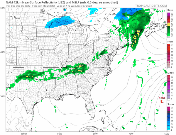
The blocking pattern is taking a solid hold now on weather patterns in the US and we have an approaching cold front. It is a slow moving front with not much punch to it. Moisture from the Gulf States and Southeast US has been making some northward progress and we can see bands of showers on the regional radar heading to the northeast.
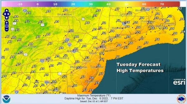
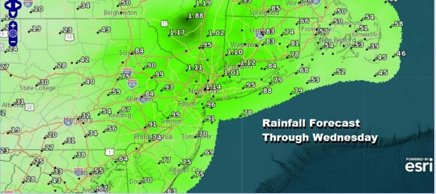
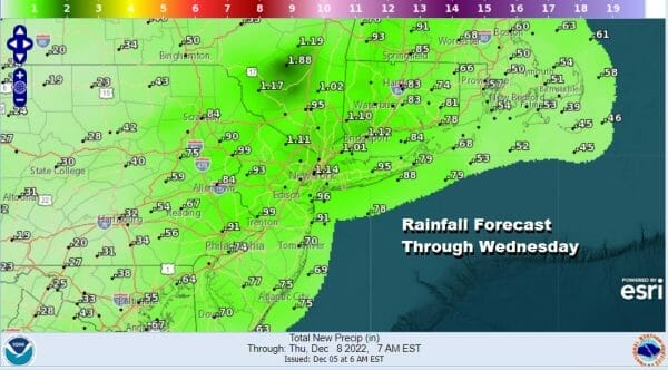
Warmer air is sweeping up the East Coast and we will have warm temperatuers this afternoon as highs reach the mid 50s to lower 60s. Showers will continue tonight into Wednesday though the rains will not be continuous and there will be some dry stretches in between . 1/2 to 3/4 inch rains are expected from this front with a few places getting as much as an inch or so. Temperatures overnight will be in the upper 40s and lower 50s and there might be some patchy fog in the mix as well.
SATELLITE

WEATHER RADAR

We will probably see a break in the showers later Wednesday morning and afternoon but we will likely remain overcast as the front draws colder. Wednesday highs will be again in the mid 50s to around 60 or so. The front passes through late in the day and winds will turn to the north Wednesday night as a cold Canadian high builds east and south and we start to see temperatures trend downward slowly.
The warm air of the next two days will still be leftover on Thursday when we will see clouds around. Perhaps we could see some breaks of sun developing with highs hovering in the low to mid 50s with a north to northeast wind. The next weather system is going to head to the Ohio Valley Friday but the low runs right into the blocking high and weakens. This will force the moisture to the southeast and the system looks rather week. Friday will be colder with clouds and some sun with highs in the 40s. We probably won’t see much if anything from this system as it slides southeast and redevelops offshore well to the south and east.

The GFS continues to overdo the late week system so for now we will lean more optimistic. The chilly onshore flow continues into the weekend and that will keep things cold and somewhat raw. Another weather system approaches Sunday with the same idea and this may be way overdone again so we will lean more optimistic. The block isn’t going anywhere and that leaves next week a bit unsettled.
BE SURE TO DOWNLOAD THE FREE METEOROLOGIST JOE CIOFFI WEATHER APP &
ANGRY BEN’S FREE WEATHER APP “THE ANGRY WEATHERMAN!
MANY THANKS TO TROPICAL TIDBITS & F5 WEATHER FOR THE USE OF MAPS
Please note that with regards to any severe weather, tropical storms, or hurricanes, should a storm be threatening, please consult your local National Weather Service office or your local government officials about what action you should be taking to protect life and property.


