
Gloom & Doom But Some Improvement Tonight & Monday
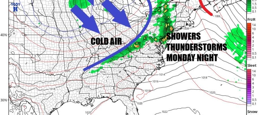
Showers Thunderstorms Monday Night

We are starting off the day with gloom & doom conditions but there is hope for some slow improvement fromt west to east as the day wears on. Low pressure is off the coast of Southern New England and rain is pushing northward into coastal New England and westward into Long Island and Southern New England. The rain is done elsewhere and to the west. As the day wears on the low will move away to the northeast and a general improving trend should settle in during the afternoon. We will describe it as a slow decrease in clouds. Winds from the northwest rather than the northeast will help the cause and highs should get back into the 50s eventually in most places.
SATELLITE WITH LIGHTNING STRIKES

WEATHER RADAR

Northwest winds will dry us out nicely overnight across Eastern Pennsylvania to Southern New England. Skies will clear from west to east and lows will be in the upper 30s to mid 40s. Monday is looking to be a nice warmer day however we do have a cold front that is approaching from low pressure over the Great Lakes.

That front is likely to set off thunderstorms across parts of the Ohio Valley and into the Appalachians and the Storm Prediction Center is indicating the risk for severe weather extends into Western and Central Pennsylvania. The risk for severe weather lessens across Eastern Pennsylvania and points eastward to Southern New England though there will be some thunderstorms developing during the late afternoon and evening hours in Pennsylvania and reaching the coast of New Jersey Connecticut and Long Island around or after sunset.
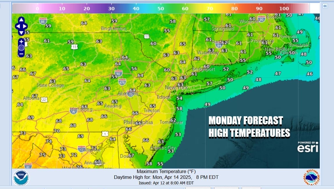
In the meantime ahead of the cold front Monday highs will be in the 60s and some warm spots will possibly reach 70. The warm up is only a one day affair as the once the front passes you can expect strong northwest winds to pick up as the pressure gradient tightens. Also an upper trough will be passing through Tuesday and once this goes by, the coldest air will arrive. Highs Tuesday will likely reach into the 60s before the upper trough passes. We will see clouds mixed with some sunshine. Some inland areas could see a scattered instability shower.

Northwest winds will be gusting 30 to 40 mph at times late Tuesday into early Wednesday. Also we will see colder temperatures arrive and lows will be in the uppe 30s and lower 40s Wednesday morning. The coldest air will be during the day Wednesday with most highs in the upper 40s to lower 50s at best. Gusty winds and sunshine are forecast. Temperatures should start to moderate Thursday and Friday and no rain is forecast until some point over next weekend as another cold front approaches.
BE SURE TO DOWNLOAD THE FREE METEOROLOGIST JOE CIOFFI WEATHER APP &
ANGRY BEN’S FREE WEATHER APP “THE ANGRY WEATHERMAN!
MANY THANKS TO TROPICAL TIDBITS FOR THE USE OF MAPS
Please note that with regards to any severe weather, tropical storms, or hurricanes, should a storm be threatening, please consult your local National Weather Service office or your local government officials about what action you should be taking to protect life and property.


