Gloom & Doom All Week Storm Spreads Rain Severe Weather
Northeast Mid Atlantic

Gloom & Doom All Week Storm Spreads Rain Severe Weather
Northeast Mid Atlantic
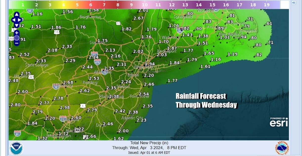
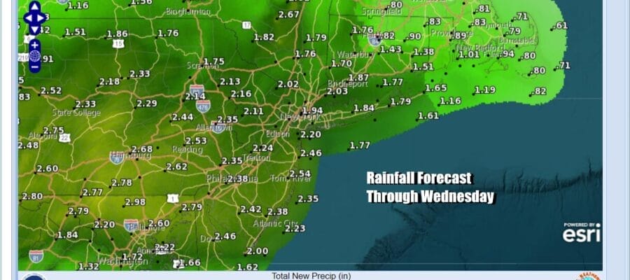
The week ahead is going to be one miserable week of weather. When it is not raining it is going to be cloudy and raw. When it is raining we could see the rain come down heavy at times. Rainfall forecast through Wednesday evening will be on the order of a couple of inches in many areas from Eastern Pennsylvania. Perhaps that the rain is spread out over a couple of days makes flooding less likely but we will need to watch this closely.
SATELLITE WITH LIGHTNING STRIKES

WEATHER RADAR

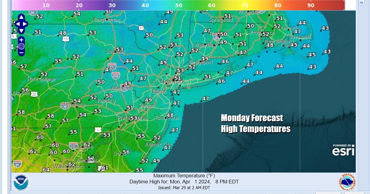
Radars are busy today with areas of heavy rain moving eastward across Pennsylvania so for most it is going to be a rainy day. There are even a few thunderstorms in the mix on the southern end of the precipitation shield. Once this first area of rain moves out later today, we will send the rest of the time under mostly cloudy skies. Highs today will be just into the 50s at best.
Attention turns to low pressure moving east from the Plains, across the Upper Ohio Valley and into Western NY. The low will redevelop near the New Jersey coast and then head into New England. This will take over 2 days to play out so we are looking at raw and rainy conditions to return Tuesday and continue on and off Wednesday into early Thursday.

Temperatures Tuesday, Wednesday and Thursday will be going absolutely no where. Highs at best will be in the low to middle 40s by day and we will eventually get into a raw northeast wind making the miserable conditions feel even more miserable. By Thursday we will see rain become more showery in nature and there will be longer dry stretches. The same holds for Friday as this storm system starts to shift away from the coast of Eastern New England.
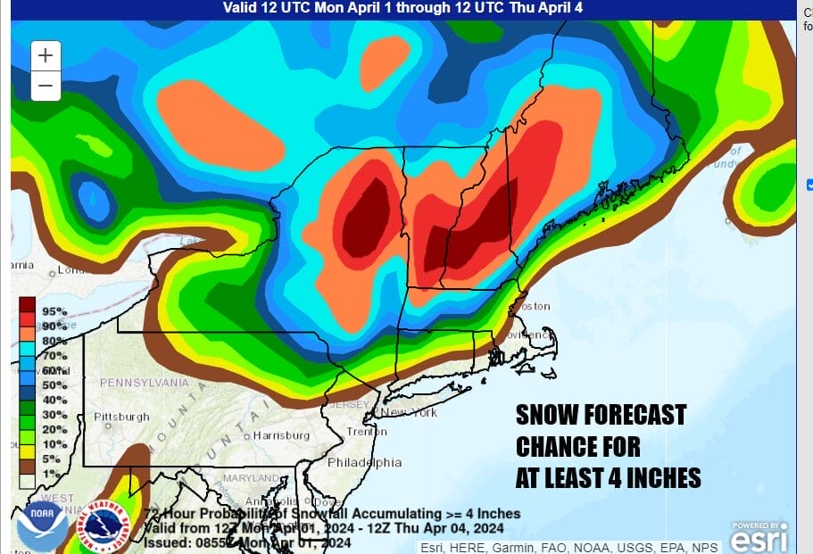
For snow lovers and late season skiers, Upstate NY and Interior New England will see accumulating snows with a high probability of at least 4 inches being indicated by the Weather Prediction Center. The bulk of any snow will fall later Wednesday into early Friday. Weather conditions should improve from west to east across the Northeast later Friday and the weekend is looking dry with returning sunshine and warmer temperatures.
BE SURE TO DOWNLOAD THE FREE METEOROLOGIST JOE CIOFFI WEATHER APP &
ANGRY BEN’S FREE WEATHER APP “THE ANGRY WEATHERMAN!
MANY THANKS TO TROPICAL TIDBITS FOR THE USE OF MAPS
Please note that with regards to any severe weather, tropical storms, or hurricanes, should a storm be threatening, please consult your local National Weather Service office or your local government officials about what action you should be taking to protect life and property.
(Amazon is an affilate of Meteorologist Joe Cioffi & earns commissions on sales.)


